
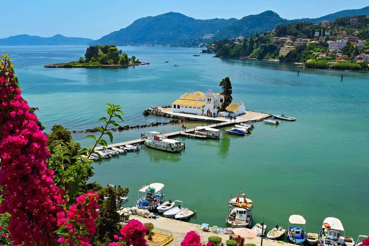
Corfu Greece is an Ionian island off the north-west coast of the mainland, close to Albania, and its Venetian old town carries a UNESCO listing. For days out elsewhere in the country, the tours in Greece on the homepage cover the mainland and the other islands.
This page walks through the land and districts, the history from ancient Corcyra to the union with Greece, the old town and its fortresses, the coasts, Mount Pantokrator, nature and food, how to get there and around, the seasons and the day trips to Paxos and Albania.
What is corfu greece, and where does it sit?
Corfu Greece sits in the Ionian Sea, at the far north-west of Greek territory. Wikipedia counts it as one of the Ionian Islands, a group in western Greece. Its small Diapontia satellites reach the westernmost point of Greece.
Albania is close to the north-east. The coast near Saranda faces the island across a strait. Its width changes along the shore, between 3 km and 23 km. Facing the south-east side is Thesprotia, on the Greek mainland. This position gives corfu greece two near neighbours. People of the island are called Corfiots, or Corfiotes in a second spelling.
The Greek name of the island is Kerkyra, with Korkyra as the older spelling. Latin writers wrote Corcyra. The Venetian and Italian form is the root of the English name of corfu greece. That form comes from a Byzantine word, Koryphai, which means crests or peaks.
Those crests are the twin peaks of Palaio Frourio, the old citadel above the town. A myth explains the older name. In the story, the sea god Poseidon carried a nymph called Korkyra to the island. He gave her name to it. So the story of corfu greece starts with a god and a nymph.
Six kilometres to the north-west lie Othonoi, Ereikoussa and Mathraki, the Diapontia Islands. Italy lies roughly 40 km from these islets. The main island and its satellites mark a sea border set by the International Hydrographic Organization. South of the line is the Ionian Sea, and north of it is the Adriatic.
In the Ionian Islands region, the regional unit of corfu greece stretches south as far as Paxos. The capital of that unit is the town of Corfu, named like the island itself. This page uses both names alike.
Three map facts place the island exactly. Its centre lies at about 39.60 degrees north and 19.87 degrees east. The clocks follow Eastern European Time, which runs two hours ahead of UTC, with one more hour in summer. These simple numbers fix corfu greece on any map or time chart.
How big is corfu greece, and what shapes its land?
Corfu Greece has an area estimated at 592.9 square kilometres. Its length is about 64 km, and its widest part is around 32 km. Two mountain ranges and a long, low south give the island its shape.
The ancient Greeks compared the outline of the island to a sickle, which they called a drepane. On a map, corfu greece still shows that long curve. The wide part lies in the north, and a narrower tail runs south.
The land falls into three districts. Mountains fill the north, rolling hills fill the centre, and low ground fills the south. A drive from one end of corfu greece to the other crosses three very different kinds of land.
The more important range is Pantokrator. Capes Falacro and Psaromita mark the two ends of the range. Its summit of the same name rises 906 metres above the sea and tops the island. The second highest peak is Stravoskiadi, at 849 metres.
The second range ends in the mountain of Santi Jeca, also called Santa Decca. Its name comes from the Greek words for the Ten Saints. The whole island is made of limestone formations, so its surface changes a great deal from place to place. Corfu greece is therefore a land of ridges, valleys and cliffs.
The coastline measures 217 km, counting the capes. Drastis lies to the north, Lefkimmi and Asprokavos to the south-east, and Megachoro to the south. Beaches line the coast at Agios Gordis, Agios Georgios, Marathia and Kassiopi. Sidari, Palaiokastritsa and the Korission Lagoon have beaches too. These places each get their own part of this page.
Two small islands lie midway between Gouvia and Corfu Bay, which spreads across the eastern shore. They are Lazareto and Ptychia, and Ptychia is also called Vido. Lazareto lies 1.1 km from the shore, north-east of the town, and covers 7.1 hectares. These two islets lie off the capital of corfu greece.
Sources give slightly different sizes. The same page also lists 610.9 square kilometres. Wikivoyage names 62 km in length and nearly 30 km at the widest point. Either way, the length is about double the width. The page on Mount Pantokrator gives the same height of 906 metres for the summit.
How is corfu greece divided into districts and towns?
Corfu Greece is one regional unit within the Ionian Islands region, and the town of Corfu is its seat. A recent local government reform gave the unit four municipalities. Beside the main island, the unit holds Paxos, Othonoi, Ereikoussa and Mathraki, plus islets.
The Kallikratis reform formed the regional unit from the earlier prefecture of Corfu. That prefecture dated from the union with Greece and covered the same land. Its two provinces were Corfu, whose capital was Corfu city, and Paxos, whose capital was Gaios. Both provinces still lie inside the regional unit of corfu greece.
Its area, including Paxos and the other islands, is 641.1 square kilometres. At the latest census the page lists, it held 101,600 people. The page on the town gives 99,134 residents for the island alone. So corfu greece is home to about one hundred thousand people.
Corfu town is the municipality’s capital, and the regional unit’s too. The Ionian Islands region also has it as capital. The town itself has 23,541 residents. Its municipal unit has 40,047 inhabitants on 41.905 square kilometres. A large share of the people of corfu greece live in or near this capital area.
The page names the other large towns in the municipal unit. They are Kanali with 4,786 people, Potamos with 3,840, Alepou with 3,149, Kontokali with 1,660 and Gouvia with 838. These towns show how the population gathers around the capital.
Wikivoyage splits the island into three travel regions instead. The mountainous north has villages. The central region has the largest population and holds Corfu Town, the capital. The southern region has resorts and beaches. These three regions give corfu greece a simple map to follow.
The municipality of Central Corfu and Diapontian Islands is split again into municipal units. They include Achilleio, Corfu city, Ereikoussa, Mathraki and Palaiokastritsa. So corfu greece is divided in layers: region, regional unit, municipality, municipal unit and village. This page follows the same layers when it names places.
Who lived on corfu greece in ancient times?
Settlers from Corinth founded the ancient city of Korkyra on corfu greece, probably in 730 BC. Earlier arrivals had come from Eretria, and the Liburnians were said to hold the island until the eighth century BC.
Wikipedia reports that Strabo named the Liburnians as masters of Korkyra for a time. The Corinthians reportedly drove them out. Scholars have also argued that the island was Taphos, home of the Lelegian Taphians. The earliest story of corfu greece is a story of peoples.
The new town sat well for trade. Corcyra stood on the sea road between Greece and Magna Grecia, and the southern lowlands were fertile. The colony stayed independent, and even hostile, towards its mother city. It grew strong on that freedom.
The quarrel with Corinth led to the Battle of Sybota in 433 BC. Corcyra held the third largest navy in Greece and joined Athens. Athens sent ten ships, with orders not to fight unless the Corinthians tried to land.
Corinth sailed with 150 ships against 110 Corcyraean ships. Crews fought by boarding, with hoplites, archers and javelin-throwers on deck. The Corinthians won the first clash. Twenty more Athenian ships then approached, and the Corinthians withdrew. Both sides claimed victory, and the Peloponnesian War followed.
Peace brought great building. Around 580 BC the city raised a temple to Artemis, among the first Doric temples built wholly of stone. It was 49 metres long and faced east, so that sunrise light entered. Soldiers digging trenches in the Napoleonic Wars found it. Corfu greece still holds its ruins.
The temple’s Gorgon pediment, dated 590 to 580 BC, shows Medusa between two panthers. Wikipedia says these figures were meant to ward off evil. The museum in the town also shows the Lion of Menecrates. It dates from the end of the seventh century BC.
A second sanctuary stood on Analipsis Hill. The Temple of Hera lies about 700 metres from the Temple of Artemis. Its high position made it easy to see from passing ships. The museum adds a pediment of Dionysus and four cases of coins from corfu greece.
How did Rome and Byzantium rule corfu greece?
Rome kept a naval station on corfu greece until at least 189 BC. In 31 BC the island served Octavian as a base against Mark Antony. Byzantium then held it as a naval outpost.
In 148 BC the island joined the Roman province of Macedonia. In Late Antiquity it belonged to the province of Epirus Vetus. The Temple of Artemis also holds a Roman link. Remnants of reliefs of Achilles and Memnon were found among its ruins in corfu greece.
Christianity came early. By tradition, Jason of Tarsus and Sosipatrus of Patras, two disciples of Saint Paul, taught the Gospel here. A church was built for their relics around the year 100 AD. That makes corfu greece an early Christian land.
War then changed the map. In 551 the Ostrogoths destroyed the city, then called Chersoupolis. Palaiopolis, the old site, stayed inhabited for centuries. The medieval town grew on the peninsula tip instead. From its twin peaks it took the Greek name Korypho, which led to Corfu.
From the early ninth century the island belonged to the naval theme of Cephallenia. Travellers saw it as a staging post between East and West. The medieval name first appears in an account of an embassy to the Byzantine court in 968. Corfu greece was a busy stop.
In 933 the city, led by Archbishop Arsenios, withstood a Saracen attack. He became its patron saint. In peaceful years a monumental church to Saints Iason and Sosipatrus rose outside the Palaiopolis wall. A later Saracen attack ended that calm for corfu greece.
Then the Normans made the island their first target three times. The first occupation ended when Emperor Alexios I Komnenos won the help of Venice. Anna Komnene called the town very strongly fortified. Angelokastro, a Byzantine castle on the western peak, belongs to this age of corfu greece.
After the Byzantine Empire broke up, Genoese privateers took the island. The despots of Epirus followed, and later the Angevin Kingdom of Sicily. Gardiki in the south dates from the thirteenth century. It is the only medieval fortress left there.
How did Venice shape corfu greece?
Venice held corfu greece from the early thirteenth century. Its nobles ruled the city from the later fourteenth century. They left walls, a moat and tall houses on narrow lanes.
In the early fifteenth century the Venetians began to replace the Byzantine defences on the promontory. They dug the Contrafossa, a sea channel, and turned the old citadel into an artificial island. The moat survives. Venice made corfu greece a fortress.
The citadel kept its two peaks. The western one, closer to town, was Castel a Terra. Castel a Mare, on the eastern peak, served for a time as a powder magazine. Earlier, the Venetians had besieged the island once without success, in the twelfth century.
The engineers Savorgnan and Martinengo designed new bastions in the mid-sixteenth century. Their work counts as masterpieces of military engineering. The New Fortress rose in stages under Ferrante Vitelli. The city faced four notable sieges, and its Venetian walls held each time.
The writer Will Durant claimed that Venice kept the Ottomans from ever conquering Greek Corfu. Not every historian needs to agree. Yet the claim shows how strong the walls looked. The name Corfu itself is the Venetian and Italian form of Koryphó.
The town plan keeps the Venetian mark. Tall houses with four or five storeys line the cobbled lanes called kantounia, and the narrowest lanes block vehicles. The Nobile Teatro di San Giacomo, the first Greek opera house, dates from Venetian times. Corfu greece shows this layer today.
Speech changed too. The island’s Italian settlers were called Corfiot Italians. They spoke Veneto da mar until the later twentieth century. Italian Jews took refuge here and spoke Italkian. Everyday Greek on the island borrowed Italian and Venetian words that still live today.
Even the small islets felt Venice. On Lazaretto, off the coast of the town, a monastery was built in the early sixteenth century. A leprosarium followed later in that century and gave the islet its name. Such details show how deeply Venice marked corfu greece.
How did the Great Siege mark corfu greece?
The Great Siege of corfu greece began on 8 July and ended on 21 August. An Ottoman army attacked the city, which Venice then held. Venice held out, and the outcome kept its rule over the Ionian Islands. Wikipedia calls it a major success for the republic.
The story has an earlier chapter in the sixteenth century. The Ottoman ruler Suleiman led a siege against the Venetian island in August and September. On 26 August his fleet of 320 ships began to bombard corfu greece. Troops of 25,000 men then landed on the island.
A French admiral, Baron de Saint-Blancard, joined the Ottomans in early September with galleys from Marseille. Venice meanwhile asked the Pope and the Knights Hospitaller for help. Its ships waited at Brindisi. They were told not to sail against the great Ottoman fleet.
Bad weather ravaged the Ottoman camp, and a plague worried the troops. Suleiman took his fleet back to Istanbul by 15 September without capturing the island. Two days later the admiral Doria arrived with 100 ships and found the siege lifted. The first attack on corfu greece had failed.
The result pushed Venice towards an alliance with the Pope and Charles V against the Ottomans. The city went on to face four notable sieges in all. Wikipedia adds that the Venetian defences proved strong each time. That is why the story of corfu greece is tied so closely to its walls.
The later siege belonged to a larger war between the Ottomans and Venice, the seventh of that name. It came one year after the Ottomans conquered the Morea. The Venetian Senate chose Andrea Pisani, already on the island, to lead the navy. Early in the year of the siege he had 18 galleys and 26 ships of the line.
In February Count Schulenburg arrived as commander-in-chief. The walls of corfu greece had been neglected for decades, so he added palisades, trenches and field works. The Ottoman fleet reached the island on 5 July and anchored in the Corfu Channel. Another army waited at Butrint, on the shore across the water.
Villagers fled into the fortifications of the city. The defenders were German, Italian and Dalmatian soldiers, Corfiots and Greeks from other regions. Behind those walls the garrison faced the Ottoman fleet and the army on the shore. The defence of corfu greece held until the siege ended on 21 August.
How did France and Russia rule corfu greece?
France took over corfu greece in October. Napoleon Bonaparte had conquered Venice, and the Treaty of Campo Formio placed the islands under French rule. The French organised the islands into three departments, and Corfu became the department of Corcyre. The long Venetian era had ended.
The three departments carried the names Mer-Egee, Ithaque and Corcyre. This was a sharp change for the islanders. Venice had held Corfu for centuries, and now Paris set the rules. The French years were short, but they left marks on corfu greece that a traveller can still trace.
One mark is the Ionian Academy. The French founded it while they ran the island as the department of Corcyre. Wikipedia calls it the first Greek academic institution of modern times. The idea of a school of higher study in corfu greece therefore began in these French years.
Admiral Ushakov then led a joint fleet of Russian and Ottoman ships that drove the French out. In the French years, the Russo-Turkish fleet ran the small islet of Lazaretto, off the town, as a military hospital. Two former rivals now stood on the same side at corfu greece.
The victors set up the Septinsular Republic under joint Russian and Ottoman protection. It was the first time Greeks had held even limited self-government since the fall of Constantinople. Its flag is still used as an unofficial flag of the region today. The republic gave corfu greece a place in a new political story.
The name Septinsular comes from the old name of the group. The Ionian Islands are traditionally called the Heptanese, which means the Seven Islands. Corfu was the northernmost of them. In that sense, corfu greece shared a common story with its island neighbours.
The peace did not last. The Treaty of Tilsit between France and Russia handed the islands to the French once more. Corfu stayed in French hands the longest of all the islands. Ioannis Kapodistrias, born in Corfu, later became the first governor of independent Greece.
How did Britain rule corfu greece before the union with Greece?
Britain ruled corfu greece as a protector. On 5 November the Treaty of Paris put the Ionian Islands under British protection. They became a new Ionian state. A Lord High Commissioner governed that state until the islands passed to Greece.
The British Royal Navy took the other islands first. It defeated the French fleet at Zakynthos and captured Kefalonia, Kythira and Zakynthos, then took Lefkada. The French held out in Corfu the longest. Once the Treaty of Paris was signed, corfu greece joined the new state under British protection.
The British granted the islands a new constitution. The islanders elected an Assembly of 40 members. This gave the Ionian state its own parliament, even though Britain kept the final word. For a traveller, the idea helps explain why corfu greece feels so tied to law and public buildings.
The Lord High Commissioner needed a home. Sir Thomas Maitland, who held that office, built a large palace of white Maltese stone beside the town. It stands as a clear sign of the British era in corfu greece. The stone itself came from the island of Malta.
Under British rule, the Earl of Guilford turned the Ionian Academy into a university. He also served as its first chancellor. It had Philological, Law and Medical Schools. Teaching covered sciences, ethics, botany, political economy and law. Today people regard it as the forerunner of the Ionian University.
Cricket arrived in corfu greece during the British years, and the leprosarium on Lazaretto reopened once renovations were done. Union came when the British government handed the island over to the modern Greek state. The other islands joined it, as the Treaty of London set out. After that, the Academy shut down in order to back the University of Athens.
Which sights fill the old town of corfu greece?
Corfu Greece has an old town that UNESCO listed in the year two thousand seven. ICOMOS advised the listing. Its sights are a Venetian citadel, tall houses on narrow lanes, and a layout of a fortified maritime city.
The protected area covers 70 hectares, and a buffer zone of 162 hectares surrounds it. The listing rests on cultural criterion four. ICOMOS experts judged that the layout, with the Venetian walls, makes the town a model fortified maritime city. The old quarter of corfu greece is therefore protected as one whole.
A peninsula carries the town on its broad part. Its tip, the Venetian citadel, is cut off by an artificial ditch with salt water at the bottom. Because the streets sit inside walls, the old town of corfu greece grew tight and compact.
The cobblestone streets are called kantounia. They are narrow, and in places they are too narrow for vehicles. A walk on foot is therefore the natural way to see this quarter. A promenade along the seashore leads toward Garitsa Bay. Multi-storied buildings stand along the lanes and show clear Venetian influence.
Venetian nobles governed the island until France took it over. The town still reflects that era. Houses from Venetian times, with traces of past splendour, stand in parts of it. A visitor to corfu greece reads this first layer in the stone.
The British layer in corfu greece is just as clear. ICOMOS experts counted British builders behind more than half of the town’s pre-twentieth-century buildings. Sir Thomas Maitland built a large palace of white Maltese stone. Bombing in the Second World War flattened whole blocks, which newer buildings later replaced.
The urban fabric is classed as mainly Neoclassical. Two castles enclose the town, and Wikipedia says it has been called Kastropolis, meaning castle city, since the Middle Ages. Wikipedia calls it the only Greek city ringed by two castles, so corfu greece stands alone.
What do the two fortresses of corfu greece show?
The Old Fortress of corfu greece sits on a promontory made into an island by the Contrafossa moat. The New Fortress was built in stages on Saint Mark hill to protect the outer town.
Byzantine town life first grew on the promontory that the Old Fortress covers. The Gulf of Kerkyra lies on its north side, and Garitsa Bay lies on its south side. The earliest sign of fortifications there dates from around the sixth century AD. A visitor to corfu greece stands on ground used for defence ever since.
The Contrafossa is a channel of seawater linking the gulf with the bay. Venetian builders dug it to strengthen their defences, and the citadel turned into a man-made island. Visitors once crossed on a drawbridge, but a fixed bridge now stands in its place.
People nearby still say the Italian name, and boats also moor in the channel, which works as a marina.
The citadel has two peaks. The higher western peak, nearer the town, was called Castel a Terra by the Venetians. The lower eastern one, Castel a Mare, served for a time as a powder magazine. Coryphe is the Greek word behind the town’s Western name. The two peaks gave corfu greece that name.
Savorgnan and Martinengo, two Venetian military engineers, designed bastions here in the sixteenth century. Wikipedia rates these bastions as top works of military design. Against three major Ottoman sieges, the fort stood firm. Because of this, Venice saw corfu greece as a bulwark facing the Ottoman Empire.
The hill of Saint Mark carries the New Fortress, which was built in stages. Its first architect was the military engineer Ferrante Vitelli. The British built the buildings seen today during their rule. The state owns it through the Greek Ministry of Culture. Wikipedia also lists the New Fortress of corfu greece as open to the public.
The compound has two levels. The lower one holds Punta Perpetua, a building of three storeys, and a pentagonal bastion. Inside the bastion, arched chambers, galleries, ventilation shafts and ramps form a maze. Two baroque gates serve the fortress.
The Seven Winds bastion rises 55 metres over the water and looks out on the mainland mountains. A dry moat follows the west walls and links the market area with the new harbour of corfu greece.
What are the Liston and the Spianada in corfu greece?
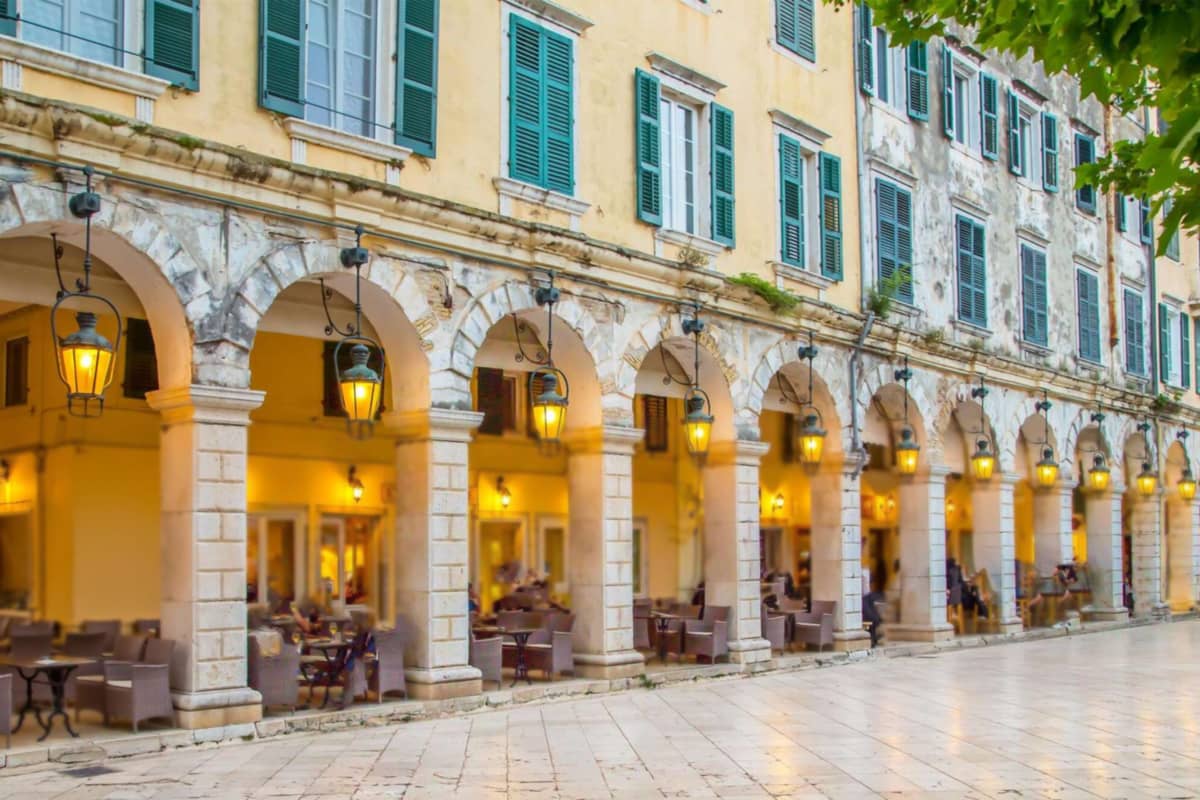
The Spianada is a large public square and park in the centre of corfu greece. Its name means esplanade, and its present form dates from French times. The Liston is the promenade beside it, named for an evening walk.
Venetian speech gave the Spianada its name, a term for an open flat space. The name recalls four centuries of Venetian rule. The square took its present shape under the short French occupation of the Ionian Islands. Later the British added cricket, so the square holds marks of three rulers in corfu greece.
The southern part is the Upper Square, named for Leonida Vlachou. It is a long area of dense greenery, flower beds and landscaped walkways. Locals call it Pano Plateia. The Municipality of Corfu runs the Spianada, a public park in corfu greece as well as a square.
At the centre of the Upper Square stands the circular Maitland Rotunda. Beside it is the musical bandstand, called the Palko. The local philharmonic societies hold events and concerts there. This keeps alive the musical life of corfu greece, which a museum of the Philharmonic Society presents in detail.
The Lower Square, named for the union with Greece, lies to the north. It is a flat, grass-covered space and holds the city cricket field, a legacy of the British protectorate. The palace that Sir Thomas Maitland built closes its northern end. The Monument of the Union of the Eptanese also stands on the Spianada of corfu greece.
The park has a playground and public toilets. Georgios Vagianos, a physician, left his whole fortune to the municipality. The Spianada fountain, called the Vagianos well, honours him. Count Schulenburg led the Venetian defence in the siege of seventeen sixteen, and his statue faces the fortress.
One explanation of the name Liston is a Venetian term for an evening promenade. Another reading ties it to the Libro d’Oro, the register of noble families, and a reserved area. It is an esplanade that links town and citadel. Restaurants and bistros fill the Liston in corfu greece.
Which churches and museums stand in the town of corfu greece?
The capital of corfu greece holds thirty-seven Greek churches, as Wikipedia counts them. Our Lady of the Cave gives the cathedral its dedication. The patron saint of the island has his own church in the old town. Two museums, one for archaeology and one for Asian art, add to the town.
Saint Spyridon has his church inside the old town. Its red bell tower rises high enough to be seen from every part of the city. A local page notes this. Wikipedia adds that no other bell tower among the Ionian Islands is taller. A walker in the lanes of corfu greece can look for it as a landmark.
The saint’s relics rest inside this church. A silver reliquary of the nineteenth century holds them, set right of the sanctuary, as the tourism page states. The island honours the saint with processions. One takes place on Palm Sunday at eleven in the morning, as Wikipedia lists it for corfu greece.
The Easter procession has its own history. It began after the island was saved from famine, as the Easter page tells it. The Venetians banned Orthodox processions on Good Friday for reasons of security. They allowed only the saint’s procession on Holy Saturday. Local people still follow that custom, celebrated only here.
Other churches add to the list. On the edge of town stands a church for two saints, Jason and Sosipater. It has the reputation of being the island’s oldest. Both a Greek archbishop and a Roman Catholic archbishop have their seat here, as the Corfu city page states. Both are part of corfu greece.
Land given by the city carries the Archaeological Museum, raised in the nineteen-sixties. It first housed the finds from the Temple of Artemis. Its prize is the Gorgon pediment, dated to 590-580 BC. The page calls it the oldest stone pediment in Greece. In the nineteen-nineties two more halls were added for newer finds.
The Museum of Asian Art sits inside the palace on the Esplanade. Wikipedia calls it the only museum in Greece given to the art of Asia. It has Chinese, Japanese and Indian collections. It began as a museum of Sino-Japanese art, built on the gift of the Gregorios Manos collection. It rounds off the culture of corfu greece.
What is the Palace of Saint Michael and Saint George in corfu greece?
This British-era palace closes the Spianada on its north side in corfu greece. Sir Thomas Maitland, the Lord High Commissioner, had it built of white Maltese stone. It served as his residence and housed the Ionian Senate.
The architect was George Whitmore. The foundation stone was laid on Saint George’s day, and the building was finished five years later, as Wikipedia states. The name comes from a British order, which also had its home here in corfu greece.
The stone came from Malta. The history page of the museum says the stone was specially imported. Maltese artisans worked on it, helped by local workers. The Corfu city page calls the result a large structure of white Maltese stone in corfu greece.
The island’s tourism page calls it one of the first neoclassical buildings in Greece. The front has a row of Doric columns, broken by two triumphal archways. The wings curve round the north end of the square. A stone ship’s prow on the cornice stands for the island, which links the palace to corfu greece.
The palace changed its use over time. Before the union with Greece, as the tourism page states, it housed the Senate and the Ionian Parliament. Afterwards it became a summer home for the Greek royal family. The British order kept its seat here until that union in corfu greece.
The same page records that the archaeological collection of the island was placed here for a short time. Today the Museum of Asian Art fills the building. The museum site says the palace walls were repaired before a European Union summit meeting was held in corfu greece. The visit shows both the British years and the art of Asia.
The Esplanade opens in front of the palace. Whitmore also designed the villa at Mon Repos. The order began as an idea of Maitland, first High Commissioner of the Ionian Islands, as the museum site states. A traveller who sees both buildings can compare two works by one architect in corfu greece.
What do Mon Repos and Garitsa show in corfu greece?
Mon Repos once served the Greek royal family as a summer home, south of the town in corfu greece. The forest of Palaeopolis surrounds it. The Museum of Palaiopolis has filled the villa since the start of this century. The entrance front faces the sea.
The villa was built for Frederick Adam, the British Lord High Commissioner, and his wife Diamantina Palatino, a Corfiot. The work ran from the late eighteen-twenties into the early eighteen-thirties in corfu greece. The couple left in the year after it was done, when Adam was sent to Madras.
The design is neoclassical, made by Colonel George Whitmore with the civil engineer J. Harper. Wikipedia describes strict symmetry, two solid masses and three floors in the English Regency style. Simple lines and large openings place the villa among the early neoclassical buildings of corfu greece.
King George I received the villa and gardens after the union with Greece. His new name for it, Mon Repos, means My Rest in French. The Greek royal family spent summers there until the late nineteen-sixties. Prince Philip, the husband of Queen Elizabeth II, was born here, as Wikipedia records for corfu greece.
The museum fills the rooms. On the ground floor, a dress and personal items of the first resident, Diamantina Palatino, sit with portraits and furniture. The finds on the first floor range from the Archaic age to Roman times. A wooden spiral staircase leads up to the second floor, which shows newer themes in corfu greece.
Mon Repos was built over the old city of Palaiopolis. Excavators found the Kardaki Temple, the Temple of Artemis and the Temple of Hera there. The Hera temple lies near the west limit of the estate, on Analipsis Hill. Passing ships saw it clearly, which ties the ancient past to corfu greece.
Garitsa is a bay beside the old town. A promenade by the seashore leads towards it, as the Corfu city page states. The Old Fortress has Garitsa Bay on its south side and the Gulf of Kerkyra on its north side. A moat called the Contrafossa joins the two waters in corfu greece.
What lies at Kanoni, Vlacherna and Pontikonisi in corfu greece?
Kanoni, Vlacherna and Pontikonisi share one short stretch of corfu greece, just south of the old town. The island’s airport sits here too. Wikipedia sets Pontikonisi only half a kilometre from the airport.
A caption on the Wikipedia page of the city names the seaside from Kanoni to a place it spells Mesoggi. The caption calls this shore a protected Natura area. So corfu greece treats this coast as a place of nature, even beside a working airport.
Ioannis Kapodistrias, a diplomat born on the island, became the first governor of Greece, and the airport bears his name. The page states that the airport was founded before the Second World War. Its runway grew from 600 metres in wartime to 2,373 metres after the last extension.
European cities send scheduled and charter flights here. The busy air season runs from April to October. A traveller in corfu greece who stays near Kanoni therefore shares the shore with arriving and departing aircraft. The town centre lies around two kilometres to the north of the field.
Pontikonisi means “Mouse Island” in Greek. It is a small islet near the island of Corfu. On it stands a chapel from Byzantine times, built for Christ Pantokrator. Wikipedia places it in the eleventh or twelfth century. The islet is a quiet landmark for anyone who studies the Byzantine past of corfu greece.
Pontikonisi has links with art and with a family of writers. The painter Arnold Boecklin is named as one possible inspiration for his work Isle of the Dead. Part of the ashes of the conservationist Gerald Durrell were scattered there. So were those of his sister Margaret. The Durrell children swam out to the islet in their youth.
The page on the island shows Vlacherna Monastery and Pontikonisi together in one photograph of central Corfu. The pairing tells you the two sites lie close. Wikivoyage adds that the airport bus makes a ten-minute ride. The Blue buses serve the town from San Rocco Square.
The island page calls Corfu a place marked by battles and conquests, and Kanoni lies close to the capital. For a short visit to corfu greece, this shore fits between the old town and the south. The Blue buses serve the town and its surroundings.
What is the Achilleion in corfu greece?
The Achilleion is a palace built on corfu greece for Empress Elisabeth of Austria. Its page states that it rose after a suggestion by the Austrian consul Alexander von Warsberg. Its name and statues honour the Greek hero Achilles.
The Wikipedia page of the city places the palace near Gastouri and describes it as Pompeian in style. The same page says the German emperor, William II, later purchased it. So the building passed from an empress to an emperor. That is a striking line in the story of corfu greece.
The empress knew the island before she built here. Wikipedia reports that she stayed at the Mon Repos villa more than once. The villa won her heart for the island. Later she built the Achilleion Palace in the village of Gastouri.
Elisabeth wanted a home worthy of Achilles. She also asked for colonnades and gardens that hide the house from prying eyes. The wish explains the Greek hero theme of the whole house. A visitor to corfu greece can still read this idea in the terraces and the garden statues.
The sculpture Dying Achilles forms the centrepiece of the Achilleion Gardens. It was created in Berlin and carries an inscription of that date. The page on the sculptor Ernst Herter lists an Achilles at the Achilleion among his works. It says the empress acquired the statue.
Elisabeth used the Achilleion only as a private palace, a refuge from the world. She received only her daughters, Archduchess Marie Valerie and Archduchess Gisela, with their husbands. Wikivoyage shows the dying Achilles in the palace gardens among the sights of corfu greece. It lists bus line 10 to Achilion from the town, every two hours.
The palace stands near Gastouri, south of the town. In the plan of a stay in corfu greece, the Achilleion pairs with Mon Repos. The empress knew both houses.
What do Benitses and the south-east coast offer in corfu greece?
Benitses is a very old, traditional fishing village on the south-east coast of corfu greece. Wikivoyage places mountains at one edge of the village and the aquamarine waters of the Ionian Sea at the other.
Wikivoyage adds that the mild climate and natural setting have drawn visitors to Benitses for a century. The village sits in the central region of the island, close to Corfu Town. That closeness makes it an easy first stop on the south-east shore of corfu greece.
The bus is the simple link. Wikivoyage names bus number 6 as the line to and from Benitses, and says it does not run quite hourly. This bus also passes the end of the airport access road. From there, the page states, the terminal is a walk of 500 metres.
Benitses has a marina too. Wikivoyage tells sailors in their own yacht that they can moor at Benitses Marina. It is not far from Corfu Town. The page also names the marina at Gouvia, very close to the town. So the east coast of corfu greece serves boats as well as buses.
Inland from the coast lie two more places. Gastouri holds the Achilleion, as the city page states. Kynopiastes is a traditional village. Wikivoyage lists its mansions of the seventeenth to nineteenth centuries, a marble church and a seventeenth-century monastery. A museum there is devoted to the olive tree.
Two small islands lie midway between Gouvia and Corfu Bay, named Lazareto and Ptychia, and Ptychia is also called Vido. Paxos and Antipaxos appear on the map of the island at the south-east side. The map thus shows how the south-east coast of corfu greece faces the small islands.
Further south the shore bends toward the capes. The page names Lefkimmi and Asprokavos as capes in the south-east. It says this side of the island faces the coast of Thesprotia. Wikivoyage describes Lefkimmi as a village with a wide, long sandy beach and very calm, shallow water.
These facts show a calm side of the coast. Fishing boats, a marina, old mansions and a long sandy beach lie close together. A trip along this shore tells you how corfu greece mixes old village life with the sea.
What do Kassiopi and the north-east coast offer in corfu greece?
Kassiopi, a village with Ancient Greek roots, belongs to the north-eastern shore of corfu greece. It began as a fishing port. Ruins of its castle rise above the roofs, and the site looks across the Corfu Channel. Old stones, a harbour and a calm bay make a compact stop.
Byzantine builders raised the main part of the castle walls at Kassiopi, though notes point to older foundations. Venetian engineers later strengthened them. The walls withstood Ottoman attacks in the sixteenth century. Wikipedia rates the ruins as archaeologically important, and they anchor the defence story of corfu greece.
The name hides a puzzle. Wikipedia offers two ideas: the Temple of Cassius Zeus, or the queen Cassiopeia, punished by Poseidon for her vanity. Spelling varies, and the Venetians wrote Casopo and Casopoli. Even the name shows the layered past of corfu greece.
Roman writers knew the place. Cicero wrote of a short stay, taking shelter in the harbour. Ptolemy called it a city, a sign of its weight under Roman rule. Suetonius reports that Nero sang at the temple altar. Sir William Smith called it the only other city of antiquity on the island, after Corcyra.
In the fifth century, the old temple of the village became a church. It was dedicated to the Holy Mother and called Panayia Kassopitra. It burned in the sixteenth century and was restored near the end of that century.
Two altars served Catholic and Orthodox worship, and inscriptions on the walls carry three dates. The building records shared faith in corfu greece.
Wikivoyage calls Kassiopi one of the more relaxed resorts. The bay is pretty, the beach is mostly stony, and the water is clear and calm. The same page links the whole coast with the nickname Kensington on sea. That label belongs to the north-east shore of corfu greece.
Kalami was the home of the British novelist Lawrence Durrell and his wife Nancy for six years. Roda, on the northern coast, was traditionally a fishing village. It has kept its character while growing into a holiday place. Both are easy names to add to a northern plan.
Wikipedia says the central road runs beside the village square, and buses stop there, 229 metres from the harbour. Parking for cars and coaches lies higher up in the village, built to ease harbour traffic. Wikivoyage lists regular Green bus departures to Kassiopi. These links make this corner of corfu greece easy to reach.
What do Sidari and the north-west coast show in corfu greece?
Sidari is a holiday village in northern Corfu, in the municipal unit of Esperies. Wikipedia calls it the site of an ancient monastery, and Wikivoyage lists its Canal d’Amour as a sight to see. The north-west shore of corfu greece starts to open up here.
Wikipedia lists Sidari among the beaches of the island, with Agios Georgios, Marathia, Kassiopi and Palaiokastritsa. A photo on its Corfu page shows the bay of Agios Georgios in the northwest. Names like these fill the shore map of corfu greece.
Wikivoyage explains the shape of the north. The northern part is wider and has more mountains than the south. Its coast is well developed, with good pebbly beaches. The south is narrower and tends to have sandier beaches. That contrast splits corfu greece into two kinds of shore.
Arillas is a beach resort that still feels like a village. Wikivoyage adds that it attracts naturists and is developing fast as a spiritual spot. The page lists it under North Corfu, so it fits a northern plan. Travellers who want a smaller base will note the name.
Lakones sits on a green hillside, and Wikivoyage calls it a typical Corfiot village. Houses from the eighteenth and nineteenth centuries stand beside churches and traditional coffee shops. Wikipedia adds that the old Palaiokastriton municipality had its seat at Lakones. It shows daily village life in corfu greece.
Nymphes is a big village at a height of 200 metres, rich in water, green and legends. Wikivoyage tells that in old times the Nymphs bathed in its waterfalls. A walk to the wells and falls shows why people tell the tale. Stories like this add myth to corfu greece.
The Diapontia Islands lie to the north-west, 6 kilometres from the main island. Wikipedia names Othonoi, Ereikoussa and Mathraki as the main three and calls the group the westernmost point of Greece. Wikivoyage counts 11 islands in all, three larger and the rest islets. They close the north-west view from corfu greece.
What is Mount Pantokrator in corfu greece?
Mount Pantokrator, 906 metres high, is the highest mountain in corfu greece and stands in the north-east. Its summit gives a view of the whole island and Albania, and Italy on clear days. A monastery, a cafe and a telecommunications station crown the top, and both roads and paths lead up.
At the top, a telecommunications station shares space with a cafe for tourists and a monastery. Its largest tower rises right above a well. The church carries the dedication of the transfiguration of Christ. It is a working summit as well as a viewpoint in corfu greece.
Angevin builders put up the first monastery here in the fourteenth century. It was destroyed in the sixteenth century. The present church dates from around the late seventeenth century, with a facade from the nineteenth. Each rebuilding adds a layer to the story of corfu greece.
Visitors reach the peak by road or on foot, and Wikipedia describes winding roads climbing from the coast. Cape Falacro and Cape Psaromita mark the two ends of the Pantokrator range. Stravoskiadi, at 849 metres, is the second summit of corfu greece.
Below the peak stands Old Perithia, the oldest village of the island. Its history goes back to the fourteenth century, and villagers supplied local wood and limestone for the first monastery. Wikipedia counts 130 houses and 8 churches there. Wikivoyage calls it the last Heritage Protected Village, an old record of rural corfu greece.
From Old Perithia, a round walk to the summit takes about two hours, as Wikipedia states. From the peak you can look down on Old Perithia and on Sinies, a village now abandoned. These slopes show how people once lived on the mountain.
The path from Spartilas up to Pantokrator forms one section of the Corfu Trail. This long-distance route runs for about 200 kilometres, starting in the south and ending in the north. At the summit, Albania lies a short distance to the east. The mountain therefore links the walkers’ route with the wider map of corfu greece.
What makes Paleokastritsa a landmark of corfu greece?
Paleokastritsa lies in north-western corfu greece. It is known for its great cliffs, its nearby beaches and a monastery on the headland. Angelokastro, the castle that gives the village its Greek name, stands a short way to the north.
On the western shore stands the village, close to Angelokastro. After the local government reform of recent years, it became part of a larger municipality. Its name is Central Corfu and Diapontia Islands, which shows how corfu greece is divided today. The small municipal unit around it covers 48.4 square kilometres.
The latest census counted 3,389 people in that municipal unit. Its communities include Lakones, Liapades, Doukades, Makrades, Skripero and Aleimmatades. The town of Lakones was the seat of the old municipality. Paleokastritsa itself is only one village in this group, and the bay is its centre.
The monastery on the headland dates from the early thirteenth century and houses a museum, as the article states it. A church of Saint Spyridon also stands near the main beach. For a traveller on corfu greece, the monastery gives a calm stop above the water. The bay lies below.
The bay carries an old story from the Odyssey. In that tale, Odysseus reached the shore of the bay and there first saw Nausicaa. It is a legend, not a record. Local people call a rock in the sea the petrified ship of Odysseus.
The article adds a neat detail about that rock. Its side toward the mainland curves like the stretched sail of a trireme, an ancient warship. The shape explains why the tale stuck. A visitor to corfu greece can look at the rock from the shore and judge the likeness.
Wikivoyage calls Lakones a typical Corfiot village, set on a green hillside. Among its houses from the eighteenth and nineteenth centuries are churches and traditional coffee shops. The same page notes a good road from the town of Corfu across the island to Paleokastritsa. It also lists regular bus departures from the Green Bus Station.
What stands at Angelokastro in corfu greece?
Angelokastro is a Byzantine castle on a steep rocky peak above the north-west coast of corfu greece. Wikipedia ranks it among the key fortified complexes of the island. No attacker ever took it, though sieges came again and again through the centuries.
Nobody knows the exact date of building. The work has been attributed to Michael I Komnenos Doukas and his son. The first written proof is from the thirteenth century. Finds from digs show that the hilltop was already used between the fifth and seventh centuries AD.
The castle was one of three that guarded corfu greece before the Venetian era. Gardiki guarded the south, Kassiopi the north-east and Angelokastro the north-west. Together they formed a defensive triangle. One purpose of the castle was to give the city below an early alarm.
The garrison signalled to the city when an enemy came near. The city lies to the south-east and is visible from the castle. From the late fourteenth to the late sixteenth century, Angelokastro served as the official capital of the island. That role makes it a key chapter in the story of corfu greece.
The sieges give the castle its place in the history of corfu greece. A Genoese force laid siege to it for a year in the early fifteenth century and was driven back. In the first great siege by the Ottomans, villagers sheltered inside the walls. In the next siege, the garrison rolled boulders onto the passing army.
Inside the walls, the highest point holds the church of Archangel Michael, on the south side. An older church with three aisles, from the Early Christian period, lies beneath it. The page also lists a small chapel of Saint Kyriaki on the east side. It is cut into the rock and holds paintings from the eighteenth century.
The main gate faces north and is guarded by a round tower. Three underground cisterns once supplied the people inside. On the western side, seven body-shaped graves were carved from the rock, and their origin is still unknown. The castle now stands as a ruin, with a restoration programme under way. Edward Lear drew it once.
What do Pelekas and Glyfada show on the west coast of corfu greece?
Pelekas sits on a hillside above the western beaches of corfu greece. Below it lies the sandy beach of Glyfada. Travel pages name the Kaiser’s Throne, a viewpoint at Pelekas, as the place to watch the sunset.
For corfu greece, two travel pages describe the Kaiser’s Throne as the main sight of Pelekas village. One of them explains the name: Kaiser Wilhelm II came here at sundown while he stayed at the Achilleion. Wikipedia notes the German emperor bought that palace in the early twentieth century. The same page dates Pelekas village to the seventeenth century.
Pelekas is easy to place on the bus map of corfu greece. Wikivoyage lists line 11, which runs to and from Pelekas every two to three hours. The village stands above a group of beaches. A traveller who stays in Pelekas finds the sea within a short drive or a walk down the slope.
Glyfada, on the west of corfu greece, lies about four kilometres down the road from Pelekas. One travel page states this. It is a sandy beach, set between steep cliffs that fall straight into the water. Another page adds that Glyfada has golden sand, and that buses from Corfu Town run to it.
Kontogialos is a second beach in the same area, and the same page also calls it Pelekas Beach. A visitor to corfu greece can compare two bays in one afternoon. Both pages place them below the village on the western slope of the island. Tracks from Pelekas lead down to other beaches on the same coast.
Mirtiotissa is a smaller strip of sand at the foot of a cliff. A steep path leads down to it. A travel page says its name comes from a monastery of the fourteenth century. The monastery honours Our Lady of the Myrtles. The page adds that four-wheel drive helps on the track.
Ermones lies along another road down from Pelekas, with the village of Vatos nearby. According to one travel page, people lived at Ermones in the Neolithic and Bronze Ages. This adds a very old layer to the west coast of corfu greece, known today for beaches and cliffs.
What do Lefkimmi and the south of corfu greece offer?
Lefkimmi is a town in the south of corfu greece, and a canal runs across its eastern side. The south is the low-lying end of the island, with sandier beaches than the north. Kavos, a seaside resort, lies in the same municipal unit as Lefkimmi.
The south of corfu greece is the flat tip of the sickle. Two mountain ranges divide the island into three districts, and the southern district is the low-lying one. Wikivoyage adds that the south is only a short way across from west to east. It tends to have sandier beaches than the rugged north.
Lefkimmi is a town and a former municipality, and the seat of that municipality was the town itself. After the local government reform of the year two thousand and nineteen, it became a municipal unit of South Corfu. Its eastern side holds a canal. For a traveller in corfu greece, that canal gives Lefkimmi a look of its own.
Lefkimmi also holds a place in the story of corfu greece. In the era of the Septinsular Republic, 1,300 Souliote refugees arrived in the town. They came after they were expelled from their homeland on the mainland, as Wikipedia states.
The beach at Lefkimmi is wide, long and sandy. It is quiet because it lies in the less busy south. Wikivoyage notes that the water is extremely calm and very shallow. This stays true even a good way out. A taverna with a children’s playground stands there. This makes the southern shore of corfu greece easy for small children.
No seaside village on the island lies farther south than Kavos. Wikipedia lists it in the community of Lefkimmi. It names young visitors from Britain, Germany and Serbia, and others from Northern Europe. Its main part is a strip beside the shoreline. The census counted 643 residents in this corfu greece village.
The south-east coast has its capes too. Wikipedia names Lefkimmi and Asprokavos to the south-east and Megachoro to the south. On this side, corfu greece faces the coast of Thesprotia. Messonghi lies on the east shore. Wikipedia describes the seaside from Kanoni to Mesoggi as protected under the Natura treaty.
What is Lake Korission, and why does it matter in corfu greece?
Korission is a lagoon on the southern part of corfu greece, with an area of 427 hectares. Dunes closed the basin from the sea, and the water, the dunes and the nearby shore have Natura treaty protection.
Agios Mattheos is the nearest village to the lagoon, in the south of corfu greece. Chalikouna Beach divides the water from the sea. A channel through the beach lets the lagoon drain. Wikivoyage calls it an inland lake behind a thin sand bar. It names the lake as the opposite extreme to Mount Pantokrator in the north.
The dunes made the lagoon. The sea lost its link to the basin as sand built up. Wikipedia places this in a span that starts 250,000 years ago and ends 140,000 years ago. This long history is one reason the lagoon matters. It is a natural feature of corfu greece that has been forming for a very long time.
The protected area covers the lagoon and the nearby coast. It includes an unusual forest of prickly juniper, which is known locally as cedar. The dunes reach heights of more than 15 metres. Orchids are plentiful, with 14 species in the dunes. Tamarisk groves, reed beds and white water lilies add to the plant life of corfu greece.
Birds give the lagoon much of its value. The list counts over 126 species. Among them are the greater flamingo and the great egret. For a bird lover, this wetland is a rich place to watch birds in corfu greece. The lagoon is a stop on the route for a traveller who likes quiet nature.
Other animals live here too. The Corfu dwarf goby is endemic, so it lives only in this lagoon and the springs around it. Hermann’s tortoise, the European pond turtle and the Balkan pond turtle are recorded in the area. The Epiros minnow also swims here. The Jersey tiger moth is among the butterflies.
The lagoon has a human past too. Diggers near the water uncovered a hippopotamus jaw fragment together with smaller bones. They also found a worked stone from the Paleolithic. The stone confirmed that people were present around the water in that distant age. So the lagoon tells a story of corfu greece far older than any castle.
What do Agios Gordios and Agios Georgios offer in corfu greece?
Agios Gordios is a seaside settlement along the western shore of corfu greece. Its beach lies downhill from Sinarades. It joins smaller coves to make a sandy strand of about 2.5 kilometres, with sheer crags rising behind it.
Locals call the village Ai Gordis. The official tourism page for the island says that sheer crags rise behind the beach. Out in the water, a rock called Ortholithi, the Upright Cliff, sticks up from the sea. This rock is easy to spot from the sand in corfu greece.
On the hills above the beach stands the traditional village of Kato Garounas. The same tourism page says it is built on the mountainside. A walk uphill from the sand therefore leads from a seaside resort to an old village in corfu greece.
Agios Georgios in the south is a village on Issos Beach in corfu greece. It is called Agios Georgios South to tell it apart from a northern village of the same name. The bay of the northern Agios Georgios lies on the north-west coast.
Issos Beach lies next to Chalikounas on the south-west coast. Wikivoyage says the high sand hills right beside the sea give it a desert look. A traveller can enjoy the panoramic view from high above. The same page suggests bringing a bike to explore the terrain. It is a different sort of shore for corfu greece.
Chalikounas is a very long stretch of land between the lake and the sea. Wikivoyage calls the natural setting unique. The lagoon drains through a channel that bisects the beach. Next comes Prasoudi, where high cliffs hang overhead. The water is clean, and the shore is a mix of sand and pebbles. Wikivoyage calls Prasoudi a remote beach.
The west side has the sandier beaches. The east tends to have calmer water, as Wikivoyage explains. Wikipedia lists Agios Gordis, the Korission Lagoon and Agios Georgios among the beaches of corfu greece. Wikivoyage also lists a beach at Messonghi on the east side.
Which islands lie around corfu greece?
Three small islands, Othonoi, Ereikoussa and Mathraki, make up the Diapontia group, about 6 km north-west of corfu greece. Wikipedia adds that the group is the westernmost point of all Greece. The island chain ends the country’s map in the west.
The Italian shore lies roughly 40 km beyond them, as Wikipedia states. A travel page lists 11 islands in this group around corfu greece. Three are larger, and the rest are islets. Their distance from the big island runs between 9 and 20 km, towards the north-north-west. Boats from Corfu port and from Agios Stefanos Avliotes serve them.
Lazaretto Island, once called Saint Dimitrios, lies 1.1 km out from the coast, north-east of the city. It covers 7.1 hectares and comes under the Greek National Tourist Organization. In the early sixteenth century the Venetians built a monastery there. A later leprosarium gave the islet its name in corfu greece.
Two islets, Lazareto and Ptychia, sit in the water between Gouvia and Corfu Bay. Ptychia has a second name, Vido, as Wikipedia states. The bay runs along a wide part of the east coast. Both islets belong to the sea view from the town.
The regional unit is larger than the main island. Wikipedia names five islands in it: Corfu, Paxos, Othonoi, Ereikoussa and Mathraki. Smaller islands complete the list. On its map, Paxos and Antipaxos appear on the south-east side. The southern end of the unit is the Paxoi. Those two have their own section later on this page.
Near Kanoni lies Pontikonisi, which means Mouse Island. Wikipedia gives the age of its Byzantine chapel as the eleventh or twelfth century. The chapel honours Christ Pantokrator. The islet is a small landmark of corfu greece, and Wikipedia calls it a Greek islet near the main island.
The Durrell family lived on the island as children, and Wikipedia notes that they used to swim out to Pontikonisi. Another islet, with Vlacherna Monastery on it, appears in the same Wikipedia picture, which is captioned as central Corfu. Together these two small islands round off the sea map.
Which animals and plants live on corfu greece?
Wikipedia states that olive trees dominate the island, and cypress trees beside them draw the typical landscape of corfu greece. Wild vegetation grows where farmers leave the land alone, and the plant list is long.
Where farming does not reach, tall maquis shrubland is the main natural cover. Deciduous oak forests follow it, and pine forests take a smaller share. Wikipedia records more than 1,800 plant species. The green hills of corfu greece hold a wide range of wild trees, shrubs and flowers.
The island is continental, which means its animals are close to those of the mainland. Wikipedia lists foxes, hares, weasels, hedgehogs and otters among the mammals. Hummingbird hawk-moths fly among the insects. In the wetlands of corfu greece, freshwater terrapins and bullfrogs live beside the water.
Birds form the richest group. About 300 species have been recorded since the nineteenth century, from the tiny goldcrest up to the greater flamingo. Eagles, widgeons, coots and kingfishers are named too. The rock partridge and the grey partridge have died out. The bird life of corfu greece has changed over the years.
On land, Hermann’s tortoise is widespread, as Wikipedia states. On the shore, the loggerhead sea turtle nests on the sandy beaches. Quiet sand therefore matters for wildlife as well as for swimmers. The beaches serve both purposes. The Korission area in the south shows this clearly.
Korission Lagoon covers 427 hectares and lies inside a Natura treaty area. Chalikouna Beach separates it from the sea. Its dunes rise above 15 metres, and reed beds, tamarisk groves, white water lilies and 14 orchid species grow there. More than 126 bird species were recorded, and the Corfu dwarf goby is found only here, in corfu greece.
Rain keeps the land of corfu greece green. Winters are very rainy, and Wikipedia ranks the island as wetter than the rest of the Greek islands. The wet months run from November to March, as Wikivoyage states.
Old Perithia lies beneath Mount Pantokrator, as Wikivoyage states. The earliest records of the village come from the mid-fourteenth century. It is the last Heritage Protected Village on the island, set in a designated area of natural beauty. The page calls it a place for walkers who care about plants, insects and wildlife in corfu greece.
How do olive groves and farming shape corfu greece?
Olive groves and vineyards fill the farmland of corfu greece. Wikipedia adds that oil and wine have come from this land since ancient times. Kumquat and bergamot orange joined these old crops in modern times, so the farms now grow a wider range.
Homer links the island with a garden. In the garden of Alcinous he places a wild olive, a fig and a grape vine. A pomegranate, a pear and an apple stand there too. Wikipedia says the apple and the pear do poorly on the island, while the other four thrive in corfu greece.
The olive tree has its own museum in the village of Kynopiastes, as Wikivoyage states. The same page lists mansions of the seventeenth to nineteenth centuries there. It also names a marble church and a monastery of the seventeenth century. The trade in olives left its mark on the villages of corfu greece, and old buildings still show it.
The vines are local too. Two local grapes are Petrokoritho, a red, and Kakotrygis, a white. Wikipedia adds that Robola came from Cephalonia. Moschato is an Aegean grape, and Mavrodaphne is an Achaean one. These grapes give the vineyards a mix of home and imported types.
The kumquat is a newer crop. Wikipedia says the mild climate supported its modern introduction, together with the bergamot orange. Cooks and distillers use both fruits in spoon sweets and in liqueurs. A bottle of kumquat liqueur is therefore a taste of the island. The Kumquat article shows such bottles in a gallery photo.
The kumquat plant is native to southern China, and it reaches 2.5 to 4.5 metres. People eat the fruit whole, and it tastes sweet and somewhat sour. The Cantonese name means golden mandarin orange. Chinese writing mentions the fruit from at least the twelfth century. A photo on the Kumquat page shows potted trees at a distillery here.
Farm animals add products. Corfiote graviera follows the gruyere style, while Corfu cheese follows the Grana style, as Wikipedia states. Corfu butter is made of ewe’s milk. Noumboulo is a pork salami made with lard, and orange peel, oregano and thyme give it flavour. Dairy and meat therefore join oil and wine in island farming.
Which foods and drinks belong to corfu greece?
The kitchen of corfu greece joins island produce to Venetian taste. Island cooks serve sofrito, a Venetian veal roast, and pastitsada, which pairs bucatini with diced veal. Bourdetto is cod cooked in a peppery sauce.
The Ionian Islands show more Italian influence in their cooking than any other part of Greece. Venice ruled them for so long. That link shows in the pasta and the roasts of corfu greece. A plate of pastitsada or sofrito tells the story of the Venetian centuries in one meal.
Almonds and honey carry the sweet side. Mandoles are caramelised almonds. Pasteli bars are set with honey and sesame, almonds or pistachios. Mandolato, a kind of nougat, is a common Ionian sweet too. These sweets are part of the island table in corfu greece.
Modern farming added the kumquat and the bergamot orange, and both are used in spoon sweets and liqueurs. The kumquat reached Europe from China in the nineteenth century. The fruit now flavours the island liqueur of corfu greece. Wikivoyage notes that a farming co-operative in one village makes kumquat liqueur and sweets.
The dairy and meat shelf is local too. Wikipedia lists Corfiote graviera, a cheese like gruyere, and a Corfu cheese like Grana. A butter of ewe’s milk adds strong flavour to cooking and baking. It also names noumboulo, a pork salami flavoured with orange peel, oregano and thyme. A picnic in corfu greece can come from these products.
Vines and olives have covered the land since antiquity. Wikipedia names two native grapes of corfu greece: Kakotrygis for white wine and Petrokoritho for red. Wikivoyage adds that small street stalls beside the roads sell local wine, honey and olive oil. A taste is easy to find between villages.
Beer has a place as well. Wikipedia counts three breweries on the island. Wikivoyage describes a small brewery in Arillas that makes four kinds of unpasteurised beer. In earlier times the island also exported citron fruit, which the Jewish community used at the Sukkot holiday. Food in corfu greece carries layers of history.
Which music, language and festivals shape corfu greece?
Music is part of daily life in corfu greece, carried by three philharmonic bands. Wikipedia names the Old Philharmonic, the Mantzaros and the Capodistria societies. The Spianada page says the local societies give concerts at the bandstand of the big square.
The Old Philharmonic wears dark blue with dark red. People call it the Palia, meaning old. The Mantzaros wears blue with white plumes and is called the Nea, meaning new. The Capodistria wears bright red and black and is called the Conte. A parade in corfu greece is easy to read by colour.
Opera has deep roots too. Wikipedia names the Nobile Teatro di San Giacomo as the first Greek opera house in modern Greece. For almost two hundred years, nearly every major Italian opera was staged there. Spyridon Xyndas, the composer of the first opera in Greek, belongs to this tradition of corfu greece.
Speech in corfu greece carries the same story. Venetian-speaking families settled on the island and were called Corfiot Italians. Their Veneto da mar stayed in use into the later twentieth century. Italian and Venetian words entered the local Greek, and Wikipedia says words of this kind are still common today. The name Corfu is the Venetian form of Koryphe.
Wikipedia records that Italian Jews took refuge on the island in the Venetian centuries. They spoke Italkian, a mixture of Hebrew and Italian in a Venetian or Apulian dialect, with Greek words added. The language of corfu greece was therefore never a single thing. It grew from Greek, Venetian and the speech of newcomers who made the island home.
Easter is the great festival, and music sits at its centre. On Good Friday the bands split into squads and play beside the Epitaph processions of single churches. In the late afternoon the squads join as one band. On Holy Saturday morning they walk with Saint Spyridon and his relics. This custom of corfu greece began in the nineteenth century.
At eleven o’clock on Holy Saturday comes the celebration of the Early Resurrection. Wikipedia says balconies in the old town are hung with bright red cloth. People throw large clay pots of water, the botides, to smash on the street. Wikivoyage adds that Christmas on the island brings music, hymns and carols in a quiet, decorated town.
What do cricket and ginger beer tell about corfu greece?
Cricket and ginger beer are the plainest British marks on corfu greece. Wikipedia says cricket came in during British rule and is popular nowhere else in Greece. It calls the island’s ginger beer, tzitzibira, a remnant of the British era.
The game has a pitch of its own. The lower part of the Spianada is a flat, grass-covered space. Wikipedia says it hosts the city’s cricket field. The local passion for the sport dates from the British protectorate. A traveller in corfu greece can watch a match with the old fortress as a backdrop.
Cricket here is more than a pastime. The Hellenic Cricket Federation is based on the island. Wikipedia calls it the only Greek sport federation based outside Athens. The largest number of Greek cricket clubs sit in this place. Kerkyraikos, Vyron and Phaeax are named as notable clubs. That makes corfu greece the home of the Greek game.
Ginger beer has a simple story. Wikivoyage says locals took up British style drinks with enthusiasm, ginger beer among them. People call it Tsitsibeera. Wikivoyage says to ask for it along the Liston or at the better cafes. A cold bottle is a small taste of corfu greece with a British twist.
Buildings of stone and brick show the British period. The Lord High Commissioner, Sir Thomas Maitland, had the palace built where the Spianada ends in the north. According to Wikipedia, it is a large building made of white Maltese stone. A Roman-style rotunda on that square also honours Maitland. Both sites stand in the old town of corfu greece.
Other buildings share the same link. Wikipedia says the buildings now standing inside the New Fortress were built by the British during their rule. The villa of Mon Repos was built for the Lord High Commissioner Frederick Adam. Colonel George Whitmore drew the neoclassical design. Each building adds a British layer to corfu greece.
Wikivoyage sums up the mix in one line. It describes tourism on the island as a tradition of at least 130 years. It names the influence of nobility from England, France and Venice. The cricket pitch, the ginger beer and the stone palace are small proofs of corfu greece. The British years left a clear trace here.
How do travellers reach corfu greece by air?
Air travellers reach corfu greece through Corfu International Airport, which carries the codes CFU and LGKR. The Greek state owns it. Regular and charter flights from European cities land there, and the busy season runs from April into October.
Roughly two kilometres separate the runway from Corfu Town, which lies to the north. The islet of Pontikonisi sits half a kilometre to the south. A flight into corfu greece therefore ends beside the Kanoni shore. The field stands only 1.8 metres above sea level.
The runway grew in stages. In the war years it was 600 metres long. Later it reached 800 metres, and then 1,260 metres, which met the needs of larger aircraft. The last extension gave it 2,373 metres. Wikipedia lists these steps for the airport of corfu greece.
The first commercial flight came from Athens. A small terminal built in the early sixties still stands and now houses the Corfu Aeroclub. The main terminal took four years to build, from the late sixties into the early seventies. It still serves the island today.
Ioannis Kapodistrias gives his name to the airport. He was a Corfiot diplomat and the first governor of Greece, and he was born on the island. A travel page says the terminal dates from the seventies. It warns of very long queues in the departures area in summer.
The ride into town is brief. Bus number 19 takes about ten minutes, as a travel page states. The gaps between buses are big, so a traveller in corfu greece checks the timetable first. Wikivoyage also says the town is where the airport is located.
Bus number 6, which runs to Benitses, also passes the airport. Its stop lies by the access road, and a walk of 500 metres leads to the terminal. Both buses give an easy start to a stay in corfu greece.
How do travellers reach corfu greece by sea?
The sea links of corfu greece lead to Italy, Albania and the Greek mainland. A travel page names direct ferry links from Venice, Ancona, Bari and Brindisi. It adds links from Saranda and Himara, and from Igoumenitsa and Patras.
The main entry point by sea is Corfu Town. According to that same page, large ferries and cruise liners tie up there. The cruise traffic runs all through the summer. Schedules differ between seasons, so anyone heading to corfu greece checks the current timetable first.
The island has Italy on its western side and Albania toward the north-east. Wikipedia says the Diapontian islets sit where the Adriatic meets the Ionian Sea. This means the waters around corfu greece link two seas, and ferries run both ways.
Albania is the closest shore. The north-east edge of the island lies off Saranda, as Wikipedia states. The channel between the two coasts is as narrow as three kilometres and as wide as twenty-three. The south-east side faces Thesprotia on the Greek mainland.
The mainland ports of Igoumenitsa and Patras sit on the Greek coast. Brindisi, Bari, Ancona and Venice sit on the Italian side. Together these ports tie corfu greece to the road and rail networks of two countries.
The Diapontia Islands lie six kilometres to the north-west of Corfu. Paxos belongs to the same regional unit. So do Othonoi, Ereikoussa, Mathraki and smaller islets. The regional unit of corfu greece is therefore a small island group, not one island.
Sailors have their own harbours. A travel page names Gouvia marina, very close to the town. In the town it names the NAOK harbour and the Old Port. Benitses Marina is also near. The Contra-Fossa moat beside the Old Fortress serves as a small marina too.
How do travellers move around corfu greece?
Buses, hired cars and boats all work for moving around corfu greece. A travel page names two kinds of bus. Blue buses run in the town and its surroundings, while green buses cover the villages. The island is about sixty kilometres long.
The blue bus terminal stands in San Rocco Square. A kiosk there displays timetables and maps. Stops have electronic displays and ticket machines. Tickets are single-journey and must be validated on the bus. They can be bought from a machine or from the driver.
The travel page lists useful blue lines for corfu greece. Line 7 runs to Dasia every twenty minutes, and every thirty minutes on Sundays. Line 10 goes to Achilion every two hours. Line 6 serves Benitses, and line 11 serves Pelekas every two to three hours.
The station for green buses stands close to the New Port. Buses leave from there for the villages. The page names regular departures to Paleokastritsa, Sidari, Kavos, Roda, Acharavi and Kassiopi. A bus ride is one way to see corfu greece away from the town.
A car can be rented at the airport or from local companies. The page says the roads are very narrow, so a small car can be the better choice. It adds that hire insurance can leave out damage to the underside of the car.
A good road follows the east coast from Sidari in the north to Lefkimmi in the south. Another good road crosses the island from the town to Paleokastritsa. Poor surfacing is common on other roads. Maps are weak for the north-west interior of corfu greece, so a free map from the hire desk helps.
Wikipedia states that Mount Pantokrator is reachable on foot or along twisting roads up from the coast. A walking route called the Corfu Trail, about 200 kilometres long, goes from south to north. Wikipedia says the way to the summit begins at Spartilas.
Inside the old walls, the stone lanes known as kantounia are narrow, as Wikipedia states. Sections of them cannot take vehicles at all. Wikivoyage notes that city traffic is loud and busy. It also mentions quad bikes for village roads, and a hired boat up to 30HP needs no licence.
Wikivoyage calls renting a boat a good way to reach beaches that are hard to get to otherwise. Lazaretto Island is 1.1 kilometres away from the town shore, off the north-eastern side of corfu greece. That makes short boat hops easy.
When do travellers visit corfu greece?
Summer is the busiest season in corfu greece, with hot, dry days and a blue sky. Spring brings green hills, autumn brings the grape harvest, and winter brings mild but very rainy weather. Each season gives the island a different mood, so the right month depends on the plan.
Wikipedia assigns the island the Koppen code Csa, which is a Mediterranean climate type. Summers are hot and dry. For winter, the source calls the weather mild to cool, with heavy rain. Plan for rain on a winter trip to corfu greece. The wet season takes up a real stretch of the year.
Rain rarely breaks the summer weather, and seasonal breezes cool the days, as Wikivoyage states. The mountain areas are cooler than the coast. Wikipedia’s airport page says air traffic peaks between April and October. Summer on the island is therefore busy as well as warm, and the airport shows it.
Spring is the green season. Wikivoyage points to the wealth of vegetation and colours at that time of year. Olive trees dominate the island, and Wikipedia says they combine with cypress trees to make the typical Corfiot landscape. A spring trip to corfu greece also meets the Easter celebration, which Wikivoyage presents as a special experience.
Autumn is the season of the grape harvest, and Wikivoyage says the whole island smells of grapes then. The same page calls it a good time to learn the daily routine of the island. The wet months run from November to March, so September and October come before that stretch in corfu greece.
Winter is mild, says Wikivoyage. Christmas and New Year bring music, hymns and carols to a quiet, decorated place. A winter stay in corfu greece suits a traveller who wants quiet streets more than beach days. It also fits the traveller who enjoys the old town without the summer crowds.
Summer crowds show at the gateways. Wikivoyage notes very long queues in the departures area of the airport in summer. It adds that cruise ships arrive throughout that season. A traveller can weigh these crowds against the warm weather when choosing a month on the island.
What do the winds and the sea do around corfu greece?
Seasonal breezes cool the summer in corfu greece, and Wikivoyage links them to good conditions for surfing. The sea differs by coast: the north-east is clear and calm, and the south stays shallow far out. Both facts help a traveller choose a beach.
The coastline of the island spans 217 km including capes, as Wikipedia states. Capes such as Lefkimmi and Asprokavos lie to the south-east. The Diapontia Islands lie 6 km to the north-west. The sea of corfu greece meets a long edge of capes, bays and small islands.
The north-east edge of the island lies off Saranda in Albania. The gap measures 3 km at the narrowest point and 23 km at the widest, as Wikipedia states. The south-east side lies off Thesprotia in Greece. Each view from the east coast of corfu greece looks across that channel.
Wikivoyage describes the waters at Kassiopi, on the north-east coast, as crystal clear and calm. It says the bay has a pretty beach that is mostly stony. A swimmer who wants clear water in corfu greece can start with this coast, as that page describes it.
Lefkimmi, in the south, has a wide, long sandy beach, as Wikivoyage describes it. The page calls the water extremely calm, and shallow even far out. It adds that the south tends to have sandier beaches, while the north has pebbly ones. These facts make the south of corfu greece a gentle place for wading.
Water is also a way to move. Boats up to 30HP need no licence to hire, as Wikivoyage states. The same page calls a rented boat a great way to explore the island. Yachts find the marina at Gouvia, close to the town, and Benitses Marina. Sailors in corfu greece therefore have more than one harbour.
The pages read for this one give no sea temperatures and no exact swimming months, so this page names none. They do give a warm, dry summer and an airport peak from April to October. Check a current forecast before a swimming trip to the island.
How long does a visit to corfu greece take?
A visit to corfu greece comes in three sizes: a short stay, a week, or two weeks. The short stay keeps to the town and the week adds one coast a day. The fortnight adds villages and the mountain. Wikipedia gives the length as 64 km and the greatest breadth as 32 km.
A short stay keeps to the centre. Wikipedia says the old town joined the UNESCO list in two thousand and seven. Two castles enclose the town, and Wikipedia calls the capital a castle city. A first day in corfu greece can be a walk between the two fortresses.
Pontikonisi, known as Mouse Island, is a Greek islet close to Corfu. Its chief feature is a Byzantine chapel from the eleventh or twelfth century. Wikipedia lists the islet as a possible source of inspiration for the painting Isle of the Dead. Gerald Durrell’s ashes were spread on it. A visit to the islet takes up a second half day.
The Achilleion makes a third half day. Wikipedia places the Pompeian style palace near Gastouri and says the German emperor, William II, bought it later. Wikivoyage lists bus 10 to and from Achilion every two hours. A short stay in corfu greece can be built around that timetable.
A week adds one coast a day. Wikivoyage describes a good north-south road on the east side, from Sidari to Lefkimmi. Another good road crosses the island from the town to Paleokastritsa. Those two roads give a week in corfu greece a simple frame to follow.
The Green buses leave from a station near the New Port. Wikivoyage lists regular departures to Paleokastritsa, Sidari, Kavos, Roda, Acharavi and Kassiopi. Each name is one coast day on the plan. Wikipedia also lists beaches at Agios Georgios, Kassiopi, Sidari and Paleokastritsa, which fills a week in corfu greece.
Two weeks leave room for slower places. Old Perithia, the oldest village on the island, sits below Mount Pantokrator, which rises to 906 metres. Wikipedia says the round trip on foot from the village to the summit takes about 2 hours. That climb suits a second week in corfu greece.
The south adds calmer days. The Korission Lagoon covers 427 hectares, as Wikipedia states. Walkers can also try the Corfu Trail, a route of about 200 km from the south to the north. Two weeks in corfu greece give time for the lagoon, the trail and the villages.
Which day trips leave corfu greece for Paxos and Antipaxos?
The day trips from corfu greece go south to Paxos and Antipaxos. Paxos lies just south of Corfu. With Antipaxos and the islets around them, it forms one group called Paxi or Paxoi.
In the Ionian Sea, south of Corfu, sits Paxos. Together with Antipaxos and the islets beside it, it makes a small group. A traveller on corfu greece finds this group as the nearest island neighbour, south of the big island.
The link is not only a line on the map. The Corfu district ends in the south at the Paxoi. It is now divided into four municipalities. Its list of islands names Corfu, Paxos, Othonoi, Ereikoussa and Mathraki. So the southern islands belong to the same district as the big island.
Paxos has Gaios as its chief town and municipal seat. Under the old prefecture, Gaios headed the province of Paxos. The town of Corfu headed the other province, so corfu greece and Paxos share a long administrative record.
The north of Paxos holds the harbour community of Lakka. Magazia lies between Lakka and Gaios, the capital. On the map, Paxos shows its places in one line, and corfu greece lies just to the north.
The Paxos page states that ferry lines connect Gaios with Corfu and with Igoumenitsa on the mainland. So Gaios is the town where a crossing from corfu greece arrives. Schedules change, so a traveller checks the current one before choosing a day.
Antipaxos is the smaller partner of the pair. On the map of Corfu, Paxos and Antipaxos appear on the south-east side, beyond the southern tip. This page keeps to place facts, so the sea caves and beaches belong to the tour pages of this site.
What can travellers see on a day across to Albania from corfu greece?
A day across from corfu greece reaches Albania, because the north-east edge of the island lies off Sarande. The gap between the two coasts ranges from 3 km to 23 km.
The map explains why the trip is so short. The north-eastern tip of Corfu looks across to the Albanian coast at Sarande. Its south-eastern shore looks at Thesprotia, a part of Greece. A traveller on corfu greece therefore looks at two different mainland shores.
Wikivoyage places Corfu east of Italy and south-west of Albania, off the far north-west coast of the country. It also lists the direct ferry links to the island. They run from Himara and Saranda in Albania, and from Igoumenitsa and Patras on the Greek mainland. Venice, Ancona, Bari and Brindisi in Italy are listed too.
Corfu Town is where the long-distance ferries dock, as Wikivoyage states. The same page says the Green bus station stands near the New Port. A day across to Albania therefore begins and ends in the town. The Old Fortress and the Spianada lie close by.
The view from Mount Pantokrator shows the other side clearly. Standing on the summit, a traveller sees all of Corfu and Albania, a short distance off. A monastery and a telecommunications station also stand at the top. In clear weather Italy shows as well, around 130 km away.
The north-east coast is the shore that faces Albania. Kassiopi sits there, and Wikivoyage describes a relaxed resort with a bay and a mostly stony beach. It calls the whole north-east coast a long-standing favourite. It adds that the waters are crystal clear and calm. This shore of corfu greece suits a quiet look across.
The Roman and Greek ruins at Butrint and the harbour town of Saranda have a tour post on this site. This page keeps to the island side of the crossing. It names the strait, the harbours and the viewpoints. From these places a traveller sees Albania in plain sight, as the map shows.
The Diapontia islands lie off the north-west of Corfu, and they mark the westernmost point of all Greece. Corfu lies 6 km off, and the Italian shore is roughly 40 km distant. A traveller on corfu greece stands, in that sense, near the western edge of the country. Crossing to Albania means turning east instead.
Which rules and customs help travellers on corfu greece?
The simplest customs on corfu greece are respect in churches, patience on narrow roads, and care with bus tickets. Saint Spyridon’s church keeps the tomb of Corfu’s patron saint, among thirty-seven Greek churches in the town.
Churches on corfu greece are places of worship, so quiet voices suit a visit. Wikipedia names the cathedral, which honours Our Lady of the Cave, among the important ones. Reputedly the oldest on the island is the suburban church of Saints Jason and Sosipater.
Wikipedia adds that a Greek archbishop and a Roman Catholic archbishop both have their seat in the city. So a visitor to the old town of corfu greece meets more than one church tradition. UNESCO has inscribed the old town, so the lanes and churches form a listed setting.
Easter is a special time on the island. Wikivoyage says the Easter celebration there becomes an experience of a lifetime. A traveller who visits then watches events from the side of the street, with respect for the local people. The same page says Christmas brings music, hymns and carols.
The old-town lanes are called kantounia. They are cobblestone streets built inside the fortifications, and Wikipedia notes that vehicles cannot always fit through them. So walking is the custom there. A driver on corfu greece plans where to park before entering the old lanes.
Village roads call for the same patience. Wikivoyage warns that the roads are very narrow, so a small car can be the better choice. It also notes poor surfacing on the roads. It adds that hire insurance does not always cover damage to the underside of a car.
Buses have their own rules. Wikivoyage explains that Blue buses serve the town and Green buses serve the rest of corfu greece. The bus information kiosk in San Rocco Square displays timetables and maps. Tickets are single-journey only and must be validated on the bus. Self-service ticket machines stand at the stops in Corfu Town.
The sea has a rule too. Wikivoyage states that boats up to 30HP do not require a licence to hire. A traveller still checks the weather and the sea first. Wikipedia lists the island clock as UTC+2, with UTC+3 in summer.
What do families find on corfu greece?
Families who choose corfu greece find calm sandy water, safe streets and open parks. Wikivoyage names the beach, the playgrounds and the parks as places where children play. It also lists the streets, since the island is gentle on young visitors.
A travel page on corfu greece is honest about one point. It says the island has no Disneyland, no children’s museums and no zoos. Still, it rates the island a sound choice for a family holiday. Parents find a calm base here, not a long list of attractions built for children.
Lefkimmi shows why a family trip suits small swimmers. The travel page describes a wide, long sandy beach in the quiet south. A taverna beside it has a children’s playground. The water is extremely calm and stays very shallow for quite a distance from the shore, which helps young children.
The coast of corfu greece splits between sand and pebbles. Wikivoyage says the north has good pebbly beaches, while the south tends to have sandier ones. At Kassiopi the beach is mostly stony, yet the same page calls the water crystal clear and calm. Families can pick a bay by its shore.
The lagoon in the south offers a different day by the water. Chalikouna Beach separates Korission Lagoon from the sea, and the lagoon covers 427 hectares. Records list more than 126 bird species at the lagoon, among them great egrets and greater flamingos. Older children can learn to spot them from the dunes.
In town, the Spianada gives children space to run. Its list of facilities includes a playground and a cricket field. The upper square has flower beds and landscaped walkways, plus a bandstand where the local philharmonic societies play. Life in corfu greece centres on this park, and the Old Fortress rises right beside it.
A sea channel, the Contrafossa, turns the Old Fortress into an island. A bridge links it to the city, and the rock has two peaks with towers. Ferrante Vitelli was the first architect of the New Fortress, which rose in stages. One travel page also names a water park in central Corfu with 51 slides.
What do walkers and cyclists find on corfu greece?
Walkers on corfu greece can follow the Corfu Trail. This long-distance route runs about 200 km from south to north. As Wikipedia states, the walk up Mount Pantokrator from Spartilas is part of that trail.
Wikivoyage calls the island an ideal place for a keen walker. Mount Pantokrator is the natural goal in corfu greece, since it is the highest peak at 906 metres. The peak can be reached by a winding road or on foot. From Old Perithia, a round trip on foot takes about two hours.
Old Perithia is the oldest village on the island and sits at the base of the mountain. Wikipedia dates it to the fourteenth century and counts 130 houses and 8 churches. From the summit, walkers also spot Sinies, a village now empty. For walkers in corfu greece, the old stone lanes are a goal in themselves.
Smaller villages reward a slow walk. Nymphes lies at a height of 200 metres, with wells and waterfalls. A legend says the nymphs once bathed there, and a walk to the water explains why. Lakones is a typical village on a green hillside, with houses of the eighteenth and nineteenth centuries and old churches.
Kynopiastes is another village for a long stroll. Wikivoyage lists mansions of the seventeenth to nineteenth centuries, a marble church and a monastery from the seventeenth century. A museum there is devoted to the olive tree. A walk through the villages of corfu greece links such small sights, one valley after another.
Cyclists meet the shape of the land first. Hills dominate the northern part, where Pantokrator rises. Wikipedia lists the second summit, Stravoskiadi, at 849 metres. Land in the south lies lower. Wikivoyage calls the east-coast road from Sidari to Lefkimmi a good one. It adds that other roads have poor surfacing and are narrow.
Weather decides the season for a walk. Wikivoyage says the summers are warm and relatively dry and the mountain areas are cooler. Wikivoyage places the rain between November and March. The same page praises spring for its plants and colours. A walker in corfu greece can match the route to the month, with the north’s slopes in mind.
What do sailors and divers find around corfu greece?
Sailors around corfu greece find a sea lane between the island and Albania that is narrow in places. The north-east edge of the island faces Saranda. Wikipedia gives the straits there as between 3 and 23 km across.
Marinas give the island a set of safe bases. Wikivoyage names the marina at Gouvia, very close to the town. In the town itself, a yacht can moor at the NAOK harbour or at the Old Port. Benitses Marina is another stop, not far from the town. Together they make sailing in corfu greece simple to plan.
Two small islands lie between Gouvia and Corfu Bay: Lazareto and Ptychia, also called Vido. Lazaretto Island covers 7.1 hectares, and Wikipedia gives its distance from the city coast as 1.1 km, to the north-east. It notes the island’s past as a monastery site and a place of care. A skipper in corfu greece passes them on the way.
Further out lie the Diapontia Islands. The group has 11 islands, three of them larger. Wikivoyage places them to the north-north-west, 9 to 20 km from Corfu. Wikipedia names the main ones Othonoi, Ereikoussa and Mathraki, and puts the group roughly 40 km from Italy. They suit a longer sail from corfu greece.
Not every sea trip needs a yacht. Wikivoyage suggests renting a boat to land on beaches that are awkward to get to otherwise. It adds one rule: hire boats with engines up to 30HP need no licence. Anyone planning this in corfu greece can check local rules first.
Capes shape the route along the shore. The coastline spans 217 km including capes, as Wikipedia states. Agia Aikaterini and Drastis mark the north, Lefkimmi and Asprokavos the south-east, and Megachoro the south. A sailor reading a chart of corfu greece will meet each of these headlands in turn.
Wikivoyage describes summer breezes that cool the island and call surfers. It calls the water at Kassiopi crystal clear and calm. The regional unit also reaches south to Paxos and Antipaxos, as Wikipedia lists. The pages read for this plan name no dive sites, so a diver in corfu greece plans from local advice.
What role did the Jewish community play in corfu greece?
The Jewish community of corfu greece has lived on the island since at least the twelfth century. Its first members came from Greek-speaking Romaniote communities of the Balkans. They owned land and vineyards, and later served the Venetian rulers as money lenders and army suppliers.
The Jewish community of corfu greece has a long record. A Jewish travel magazine states that Jews have lived on the island since at least the twelfth century. A heritage page adds that the traveller Benjamin of Tudela met one lone Jew here in the late twelfth century.
Under Venetian rule, which ran from the fourteenth to the eighteenth century, the community prospered. Its members owned land, including vineyards. They lent money to the Venetian rulers and supplied the army with food. Others even joined its ranks.
The quarter rules came in the seventeenth century. The doge ordered the Jews of corfu greece to move into a ghetto. The magazine gives their protection as the reason. The area is still called Evraiki, a word for Jewish. Before the ghetto, Jews lived in a part of the Campielo quarter named Evreo Vuni.
Two groups shared the town. Until the Second World War, the Romaniote Jews and the Italian Jews of the island lived with constant friction. Each group kept its own cemetery. The community therefore held two traditions side by side.
Four synagogues stood in the ghetto before the Second World War. Only the Greek one, La Scuola Greca, remains in corfu greece today. A heritage page says it is built in Venetian style and dates to the seventeenth century. A red sign in the old town points the way to it.
The ghetto lost its unity through bombardments in the Second World War, as a heritage page states. Today the story of the Jews of corfu greece is carried by a small community of about sixty people. They mark Passover with a Seder, and a cantor from abroad leads prayers at the High Holidays.
Which villages inland show the old life of corfu greece?
Old Perithia is the oldest village in corfu greece. It lies at the base of Mount Pantokrator, dates to the fourteenth century, and holds 130 houses and eight churches. Four more inland villages, Lakones, Sinarades, Afionas and Kynopiastes, add stone mansions, old churches and hill views.
Old Perithia sits on the northern flank of the mountain. Wikivoyage calls it the last Heritage Protected Village on the island, set in a designated area of natural beauty. The same page says it suits walkers and people who like plants, insects and wildlife. It shows the old life of corfu greece in stone.
The villagers helped build the first monastery on the summit, using local wood and limestone. A round trip on foot from Old Perithia to the peak takes about two hours, as Wikipedia states.
That first monastery dates to the fourteenth century. It was destroyed around the sixteenth century, and the current church dates from around the late seventeenth century. From the summit you can also see the abandoned village of Sinies. Both add to the old life of corfu greece.
Lakones is a typical village of corfu greece, standing on a green hillside. Wikivoyage lists churches and traditional coffee shops among its houses of the eighteenth and nineteenth centuries. Wikipedia names Lakones as the town where the old Palaiokastriton municipality had its seat.
Sinarades is a community in northern Corfu, southwest of Corfu town. It is the largest village of the Parelioi municipal unit. Aspes and Kontogialos are small villages within its community.
Afionas stands on a high promontory in the north-west of corfu greece. It lies 37 km from Corfu Town. Its views reach the Diapontia Islands and the bay of Agios Georgios. Old mansions, coloured houses and cobblestone streets fill the village. Its parish church was built in the seventeenth century.
Between Afionas and Porto Timoni beach lie ruins of medieval walls that guarded against pirate raids. A Neolithic settlement was found nearby. The Archaeological Museum of Corfu displays what was found there.
Two more villages round off the story of corfu greece. Nymphes is a green village at a height of 200 m. A legend says the Nymphs once bathed in its waterfalls. Kynopiastes keeps mansions of the seventeenth to nineteenth centuries, a marble church and a museum devoted to the olive tree.
What do the Ionian Academy and the Reading Society show about corfu greece?
The Ionian Academy and the Reading Society show that corfu greece led learning in modern Greece. The academy was the first Greek academic institution of modern times. The Reading Society is called the oldest intellectual institution in modern Greece. Both grew from the island’s links with western Europe.
The French set up the Ionian Academy during their years on the island. It became a university under British rule, through the actions of the Earl of Guilford, who was its first chancellor. He also gave the physician George Therianos of Zante a professor post in the Medical School of corfu greece.
Three schools ran there: Philological, Law and Medical. Public courses covered physiology and botany, and also ethics and the humanities. Political economy was taught too, as were penal and civil law. Students therefore met both old and new fields of study in one town.
The Medical School ran in two periods, with a gap between them. Its physicians followed the traditional path of study in Italy, in particular at Bologna. Giovanni Carandino studied in Paris, Italy and England, then became director of the school of Mathematics. Such careers tied corfu greece to the schools of western Europe.
The end of the academy came with the union of the Ionian Islands and Greece. It closed to support the new University of Athens. Part of the staff moved to Athens, and the library was brought there. The building itself was fully restored after the air raids of the Second World War.
The Corfu Reading Society began in the nineteenth century. Fourteen young citizens founded it after they returned from studies in Western Europe. They followed the model of the Reading Society of Geneva. Ioannis Kapodistrias and Andreas Kalvos had been members of that society. Its home stands where Kapodistriou and Sofokleous Dousmani streets meet in corfu greece.
Members included the Ionian writers Dionysios Solomos, Andreas Kalvos and Lorentzos Mavilis, and the painter Angelos Giallinas. Today the library is open to visitors, with books and archives dating back to the sixteenth century. Its capstone is the Heptanese library, which relates to the Ionian Islands.
Which notable people were born on or linked to corfu greece?
Corfu Greece has ties to notable people. They were born there, spent their childhood there or lived there for a long period. Ioannis Kapodistrias was born on the island and became free Greece’s first head of state. Prince Philip’s birthplace was the Mon Repos villa. Authors and royal guests add more names.
Ioannis Kapodistrias was born on 10 February into a noble family. At that time the island was under Venetian rule. A plaque on the family home in the town states that he was born there. His story is the first one told about corfu greece and its sons.
After his studies in Padua, he opened a medical practice on his native island at the age of twenty-one. When Russian and Turkish forces held the island, he became chief medical director of the military hospital.
Later he served as a minister of the Septinsular Republic, then as foreign minister of Russia. He ended as the first governor of independent Greece. Wikipedia also calls him a distinguished European diplomat. The life of one doctor from corfu greece shaped a nation.
Prince Philip was born on 10 June on the dining room table at Mon Repos. He was baptised in the Greek Orthodox rite at Saint George’s Church in the Old Fortress. The birth is a royal chapter in the history of corfu greece.
Empress Elisabeth of Austria stayed at Mon Repos more than once. The villa won her heart, and she later built the Achilleion palace at Gastouri. Her visits show why the island drew European courts long before the age of package holidays.
Three books by the naturalist Gerald Durrell recall his childhood on the island in the late nineteen-thirties. One of them is My Family and Other Animals. His brother Lawrence Durrell wrote a volume about Corfu too. Wikivoyage says Lawrence lived in the village of Kalami for six years. Their books carry corfu greece to readers far away.
Mary Stewart set her novel This Rough Magic on the island. Prospero’s island in Shakespeare’s The Tempest is said to be based on Corfu. The Venetian-born British photographer Felice Beato is thought to have spent much of his childhood here. These stories keep corfu greece in books and pictures.
How did tourism grow on corfu greece?
Tourism on corfu greece grew from royal and elite visits to a wide public. The jet airliner brought package holidays. Until the early twentieth century, European royals and elites came. Today the island is a popular destination with resort areas in the north, centre and south.
Wikivoyage states that the island has a tradition in tourism of at least 130 years. In that time, it says, Greek education met the influence of nobility from England, France and Venice. The trade in visitors on corfu greece therefore has long roots.
Up to the early twentieth century, the island was mainly visited by European royals and elites, as Wikipedia explains. It names Emperor Wilhelm II of Germany and Empress Elisabeth of Austria. Families of the middle class, primarily from the United Kingdom, Scandinavia and Germany, visit today too. That change reshaped corfu greece within a short time.
The jet airliner brought package holidays to these groups. Wikipedia calls the island one of the primary destinations for this new form of mass tourism. Corfu International Airport receives flights from all over Europe in the summer season, as Wikivoyage states. A traveller to corfu greece in summer joins this busy flow.
Corfu Town holds the airport and also the docks for cruise ships and long distance ferries, as Wikivoyage states. In summer, it adds, cruise ships arrive in the port. The old town is on the UNESCO list, so day visitors from the ships walk its lanes. This is one face of corfu greece.
The resort areas of corfu greece differ from coast to coast. Kavos in the south is a lively resort, popular with young visitors from Britain and the north of Europe. Roda was traditionally a fishing village and kept its character while it grew into a holiday destination.
The quiet village style survives in places. Arillas is a beach resort that still feels like a village. Nature sites sit beside the resorts too. Wikipedia notes that the Korission Lake Nature Reserve is a stopover for European birds migrating south.
The quieter seasons show another side of corfu greece. Wikivoyage describes spring as green, rich in vegetation and colour, and it calls Easter a special celebration. Autumn is the season of the grape harvest, when the island smells of grapes. Christmas is a quiet, decorated time with a mild climate.
How do Orthodox and Catholic communities live side by side in corfu greece?
Orthodox and Catholic communities share corfu greece because Venice promoted the Catholic Church for four centuries. Today the majority of Corfiots are Greek Orthodox. Wikipedia describes a small Catholic minority that lives in harmony with them and traces its faith to Venetian times.
Venice held the island from the thirteenth century, as Wikipedia states it. The Venetians promoted the Catholic Church throughout their rule. The small Catholic community of corfu greece traces its faith to these origins. It has lived beside the Orthodox community ever since.
Today’s Catholics are mainly families who came from Malta, and also from Italy. Wikipedia puts the community at about 4,000 people, with two thirds of Maltese descent. They live almost exclusively in the Venetian Citadel of the town. The old walls still shape their daily life.
Like other native Greek Catholics, they celebrate Easter by the same calendar as the Greek Orthodox church. So both communities keep Easter on the same days. Wikivoyage calls the Easter celebration on the island a special experience.
In the town, the Cathedral of Saint James and Saint Christopher serves as the see of the Catholic archbishop. Wikipedia adds that the town is the seat of both a Greek and a Roman Catholic archbishop. The two offices sit in one small city in corfu greece.
On the Orthodox side, Wikipedia counts thirty-seven Greek churches in the town. The Orthodox cathedral carries the name of Our Lady of the Cave. In Saint Spyridon’s church lies the saint who is patron of the island. Together these churches give corfu greece a strong Orthodox character.
The Kapodistrias family moved to the island in the thirteenth century and changed from Catholic to Orthodox, according to Wikipedia. Venetian, French and British rule left Italian and English marks on the town.
Words from Italian and Venetian entered the local Greek speech in great numbers. In this way corfu greece became a meeting point of churches and cultures.
What else do travellers ask about corfu greece?
Why is the old town of corfu greece on the UNESCO list?
The old town of corfu greece was inscribed in two thousand and seven, at the thirty-first session of the Committee. ICOMOS had recommended the step. The site is listed as a cultural property under criterion four. The inscribed area covers 70 hectares, and a buffer zone of 162 hectares surrounds it.
ICOMOS judged that the street layout and the Venetian walls make the town a model of a fortified port city. That judgement explains why corfu greece is on the list. Two peaks rise inside the Old Fortress, and strong towers have guarded both for centuries.
The same experts described the buildings as mainly Neoclassical, without special architectural features. They also noted that new buildings of the nineteen-sixties and seventies fill gaps left by wartime damage. For a traveller, the lanes and the walls tell the story, more than any single house.
How does corfu greece fit into the Ionian Islands group?
Among the Ionian Islands, Corfu lies furthest north, off the far north-west coast of Greece. On a map, corfu greece sits at the top of the chain. The Greek name Heptanese means Seven Islands, yet the chain also holds smaller islands.
Under Venice, the islands formed the one part of the Greek-speaking world that never came under Ottoman rule. Corfu, Paxi and Kythira fell to Venice in the early thirteenth century. This followed the Fourth Crusade, which broke up the Byzantine Empire. Thousands of settlers from other parts of the Venetian Republic formed the base of the Corfiot Italian community.
After the French years, a Russian and Ottoman fleet set up the Septinsular Republic. It was the first self-governed Greek state since the Middle Ages. Britain later ruled the islands as a protectorate. Britain ceded them to modern Greece under the Treaty of London. Kythira now belongs to the Attica region.
Who was born in corfu greece and became a leader of Greece?
Ioannis Kapodistrias was born in corfu greece on 10 February, when the island was under Venetian rule. He came from a noble family, and a plaque marks the family home in Corfu. His ancestors had moved to the island in the thirteenth century and became fully Greek in language and faith.
He trained in Padua, then began medical practice on his native island at the age of twenty-one. Later he became one of two ministers of the Septinsular Republic. In time he served as foreign minister of Russia and worked for Swiss unity and independence.
Greeks chose him at the Third National Assembly at Troezen to lead the newly independent state. He served as its governor. Wikipedia also calls him the architect of Greek independence. Today the island airport carries his name, so a flight into corfu greece ends at a place named for him.
Which writer lived at Kalami, and how did the island get its name?
The British novelist Lawrence Durrell lived at Kalami on the north-east coast, together with his wife Nancy Isobel Myers. Wikivoyage lists Kalami among the villages of North Corfu. For readers of Durrell, corfu greece therefore means one particular bay, as well as a whole island.
The myth behind the name of corfu greece links two water deities, Poseidon and the river Asopos. In the story, Poseidon loved the nymph Korkyra, a daughter of Asopos. He took her to an island that had no name, and the island took her name.
Their child, Phaiax, gave his name to the islanders, who were called Phaiakes, or Phaeacians. The Phaeacians therefore give the island its old nickname. The western name Corfu comes from the Byzantine word Koryphai, which means crests or peaks. It points to the two peaks of the old fortress.
How does corfu greece compare with Cephalonia?
Cephalonia and Corfu are both members of the Ionian chain, and corfu greece lies at its northern end. Wikipedia names Corfu as the Ionian island with the biggest population. The two islands share one sea, yet their stories split in the Middle Ages, under different rulers.
Venice took Corfu in the early thirteenth century. Kefalonia and Zakynthos instead formed a County palatine under French and Italian dukes. Kefalonia passed to Venice only in the late fifteenth century. In the British era, the Royal Navy captured Kefalonia first, while the French held out in Corfu for longer.
The two also share a natural risk. A geological fault named after Kefalonia runs close to Corfu, and earthquakes have occurred there. This fact links the island in the north to its neighbour in the south. When you plan a trip to corfu greece, you can treat Cephalonia as a second island worth its own visit.