
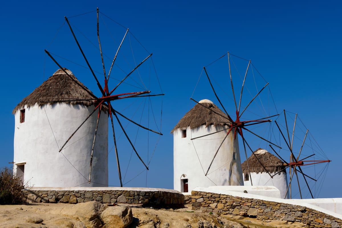
Mykonos greece is a small, dry island of the Cyclades with a white town of winding lanes, a row of windmills on the ridge and a short boat link to the sacred island of Delos. Use the facts below to place the island beside other tours in Greece.
The page covers the land and its size, the towns and villages, the ancient story, the Venetian and Ottoman years, Mykonos Town, Delos, the beaches, the quiet villages and monasteries, food and crafts, the seasons, and how to reach the island.
What is mykonos greece, and where does it lie?
Mykonos greece belongs to the Cyclades, the Aegean island group, and Wikivoyage puts it in the middle of that sea. Compass points fix its place. Tinos is to the north and Syros to the west, while the pair Paros and Naxos lie to the south. Athens is 150 kilometres away to the west, as Wikipedia measures it.
Delos gave the Cyclades their name. Wikipedia describes a ring of islands drawn round the sacred Delos, and the group is named for that circle. Delos lies close to mykonos greece, so the ring and the island share one story. The official Greek tourism site places Mykonos in the heart of the Cyclades.
In the administrative sense, Wikipedia gives the island to the South Aegean region. It pins the island at 37.45889 degrees north and 25.36417 degrees east. A map or a phone shows the same spot, so those figures settle where the island lies. The people of the island are called Mykonians, as the summary box states.
Wikipedia gives two prevailing theories for the name of mykonos greece. The first comes from Hesychius of Alexandria, who suggested the ancient Greek word Mykon. Roughly translated, Mykon meant a heap of stones, or simply rocky ground. That reading fits the rocky ground that the next section describes.
The second theory for mykonos greece comes from Stephanus of Byzantium. He tied the name to a hero called Mykonos, the son of Anius. The mythology section of the same article calls this hero the island’s first ruler. It names the god Apollo as his grandfather. Wikipedia presents both stories as theories.
Visitors drive the economy of mykonos greece, since Wikipedia counts tourism as a major industry. Wikivoyage lists Mykonos as a popular tourist destination. It also sits among the Aegean islands that draw the biggest numbers of visitors. A later section of this page shows how travellers reach the island and move around it.
How big is mykonos greece, and what shapes its land?
Wikipedia reports 85.5 square kilometres for mykonos greece, with the land climbing to 341 metres at its top. Wikivoyage measures the island from end to end at 12 to 15 kilometres, with 10 kilometres from side to side. It counts Mykonos among the smallest Cyclades islands.
Naxos holds the title of largest island in the Cyclades, Wikipedia notes, while Mykonos sits at the small end. The old Cyclades prefecture, which covered the whole group, measured 2,572 square kilometres. Mykonos is a minor slice of that total. Wikipedia’s summary box shows 125 residents for each square kilometre.
Rock dominates the ground of mykonos greece: Wikipedia calls the terrain very rocky and mainly granite. Strong winds have worn the stone away in places. Those same winds earned the island its other name, the Island of the Winds. The growing season for plants begins around mid-autumn and ends as summer starts, the article adds.
Wikipedia describes the Cyclades as mountain tops of a terrain that has sunk beneath the sea. Two volcanic exceptions stand out, Milos and Santorini. Mykonos is not one of the two, so its land is not volcanic. On soil, the same page makes one exception: Naxos. Elsewhere in the group the ground is not very fertile.
No river runs across mykonos greece, and Wikipedia mentions only seasonal streams. It adds that two of them now serve as reservoirs. The low rainfall has a cause on the mainland, according to the article. The Pindus range casts a rain shadow and dries the westerly winds. The land holds little running water as a result.
Sea water fills the gap. Reverse osmosis turns it into 4,500 cubic metres of water every day, Wikipedia reports, to help supply residents and visitors. The same source names water shortages among the problems of the Cyclades. Mykonos greece therefore draws part of its supply from the sea.
Mining once shaped the east of mykonos greece. Wikipedia reports that high quality clay and baryte came from the eastern side until late in the twentieth century. Baryte serves as a lubricant in oil drilling, the article explains. Granite, clay and baryte are the three materials that it ties to the ground.
The municipality is larger than the island. Wikipedia gives its total area as 105.183 square kilometres. Delos, Rineia and the uninhabited islets belong to it as well. The main island, at 85.5 square kilometres, forms the larger share of that total. The other islands and islets fill the rest.
Wikivoyage sets the main town on a wide bay, with the harbour at its centre. It names Panormos Bay on the north side, facing east. It also sorts its beach entries by coast: south, east, north and west. So mykonos greece has a shore on each of the four sides. The main town lies on the western shore.
How is mykonos greece divided into towns and villages?
Wikipedia lists ten villages on mykonos greece, and the main town, Mykonos, also called Chora, is one of them. Wikivoyage names two main communities, Ano Mera and Chora, and calls Chora the port town and the capital. The largest town lies on the west coast.
Chora means the town in Greek. Wikipedia calls it a common practice in Greece for the main town to carry the name of the island. So a traveller to mykonos greece hears Mykonos Town and Chora for the same place. Both names point to the capital.
Wikipedia names the ten villages of mykonos greece in one list. Chora is the town and Ano Mera the inland village. The other eight are Agios Ioannis, Agios Stefanos, Ftelia, Kalafati, Ornos, Platys Gialos, Psarrou and Tourlos. Wikivoyage writes Psarou with one r, so both spellings are in use.
Ano Mera is a small inland village at the centre of Mykonos. Wikivoyage names Ano Mera as the only settlement away from the coast, and as one of the two main communities. Measured from the town, it puts the village about 7 kilometres to the east. Every other place on the list of mykonos greece therefore lies on the coast.
Agios Ioannis is a small settlement, Wikivoyage notes, with just two taverns, a restaurant and a tiny store. Its place is south-west of the town, at a distance of 4 kilometres. Agios Stefanos, 3 kilometres north, has hotels, restaurants, taverns and cafes. Ftelia lies near Ano Mera, in the southern part of Panormos Bay.
Wikivoyage describes Ornos, a village of mykonos greece, with places to stay, food and drink, and a food market. The market has a pharmacy, a supermarket, a bakery and a butcher’s shop. Platys Gialos draws tourists as a resort. Tourlos has a marina for yachts and fishing boats.
The latest census counted 10,704 inhabitants on mykonos greece, Wikipedia states. Its census table starts at 3,863 for nineteen seventy-one. The geography section gives nearly 12,500 and places the bulk of the people in Chora. The counts differ, so read each one as the page states it.
Mykonos is also its own regional unit within the South Aegean. Wikipedia names its municipality as the only one in that unit. The Kallikratis reform of twenty eleven carved the unit from part of the old Cyclades prefecture. So mykonos greece is run as a single municipality.
Who lived on mykonos greece in ancient times?
The first people named on Mykonos Greece were the Carians, whom Herodotus mentions as the original inhabitants. Settlers from Athens, the Ionians, appear to have come next, in the early eleventh century BC. The island lay right beside Delos, the meeting ground of a league.
Wikipedia calls ancient Mykonos Greece a rather poor place, short of farming resources. Its people were polytheists, who honoured a range of gods. Delos, next door, held a large population in those days, the article adds.
The Delian League met on Delos. That made Mykonos Greece a stop for supplies and transit. The league formed after the Persian Wars, in 478 BC. Delos hosted its congresses, and its common treasury stayed there until Pericles sent it off to Athens in 454 BC.
Athens left a mark on the holy island next door. It performed a number of purifications there, and the tyrant Pisistratus directed the first. On his order, graves in view of the temple were dug up. The bodies went to another island close by. That first purification belongs to the sixth century BC.
Thucydides claims that Carians were the first people of Delos, until King Minos of Crete expelled them. So the Carians appear in the early story of both islands.
The Hellenistic period began with the death of Alexander the Great. In those years the League of the Islanders counted Mykonos Greece among its members. Rome took control of the island next. In 166 BC, Strabo writes, Rome made nearby Delos a free port. The Byzantine Empire then held Mykonos until the twelfth century.
Myth places the Gigantomachy, a great battle of Zeus against the Giants, on Mykonos Greece. In the tale, Heracles killed the invincible giants after drawing them out of the protection of Mount Olympus. Myth says the rocks lying across the island are the petrified bodies of those giants.
Wikivoyage finds Mykonos Greece short of sites from the Bronze Age, the Archaic period and the Classical period. It calls that startling, given how close Delos lies. The museum in Mykonos Town, described below, holds finds from the islet of Rhenia instead. Delos has its own section further on.
How did Venetians, Ottomans and pirates shape mykonos greece?
Direct Venetian rule over Mykonos Greece began in the last years of the fourteenth century. An Ottoman fleet settled there in the sixteenth century, and the island stayed under Ottoman control for nearly three centuries. Trade brought wealth, and it brought regular pirate raids too.
The story before Venice starts in the early thirteenth century. When the Fourth Crusade took Constantinople, Andrea Ghisi occupied Mykonos Greece. The Catalans ravaged the island as that century closed. Venice then took it under direct rule.
Hayreddin Barbarossa served Suleiman the Magnificent as admiral. He struck Mykonos in the sixteenth century, while the Venetians still reigned. An Ottoman fleet then settled in. Wikipedia says the Ottoman period on Mykonos Greece lasted until the nineteenth century.
Under the Kapudan Pasha, the Ottomans set up self-government on Mykonos Greece. A governor led it, together with a council of syndics that the rulers appointed. Tinos, the neighbouring island, lost its castle to the Ottomans in the early eighteenth century. After that, the last Venetians left the region.
Until the end of the eighteenth century, Mykonos Greece prospered as a trading centre. Settlers from nearby islands moved in, while pirates raided on a regular basis. Late in that century, in June, the Battle of Mykonos took place in the harbour, between British and French ships.
The Venetians left a mark on the hills above the town. In the sixteenth century they built the windmills of Kato Mili. Use of the mills ended only in the early twentieth century. Two travel pages say the lanes were laid out as a maze to confuse pirates and invaders.
The Greek Revolution began in the early nineteenth century. Mykonos Greece took an important part. Manto Mavrogenous, a national heroine, led the island. She was an aristocrat with a good education, and she followed the ideas of the Enlightenment. She gave up the fortune of her family for the Greek cause.
Another page calls her la Bella Greca. It says she was born in Italy into a rich Greek family. After she reached Mykonos Greece, she took part in the liberation from the Ottomans. The Greek state became independent in the nineteenth century, which ended Ottoman rule on the island.
Sailing and trade lifted the economy for a time. It declined again in the late nineteenth century. Mykonians moved away for work, to the Greek mainland and to other countries, above all the United States.
What does Mykonos Town show on mykonos greece?
Mykonos Town shows the classic Cycladic look of Mykonos Greece. The national tourism site lists paved lanes, white houses with blue windows, wooden balconies, flowerpots and churches. Wikivoyage adds that fast growth has not erased the traditional building style of the town.
Whitewash covers the lanes, houses and churches of the town, Wikivoyage states. All of them gather round the harbour. The national tourism site adds flowerpots filled with colourful, fragrant flowers to the picture of Mykonos Greece. A travel page mentions purple bougainvillea against white stucco and blue trim.
The windmills of Kato Mili on Mykonos Greece get their name from the Greek for lower mills. Wood and straw cap them. Restoration has turned the mills into homes for locals and into vaults that keep Mykonian heritage documents. Camel Rock lies offshore near the windmills, and its shape recalls a camel resting in shallow water.
Little Venice sits at the far western edge of Mykonos Town. Old fishing houses stand in rows along the waterfront, with balconies that reach out above the waves. Wikipedia traces the earliest of them to the mid-eighteenth century. Their first owners were rich merchants or captains, and bars, cafes and shops fill a number of them now.
Kastro is the oldest quarter of Mykonos Town, and Panagia Paraportiani stands there. The name Paraportiani means standing beside the door, and the door was the gate of an old castle. The Ghisi family raised that medieval castle early in the thirteenth century. Builders began the church in the fifteenth century, and work ended in the seventeenth.
The whitewashed landmark is five churches in one. Four of them form its base, and a fifth church stands built above them. Wikivoyage states that one ground chapel only is open to the public, from early morning until sunset. It ranks the church first for photographs among the 400 churches of Mykonos Greece.
The old harbour lies a short step from Little Venice. A travel page notes colourful fishing boats and a tiny church by the entrance of the main dock. The pelican Petros, mascot of Mykonos Greece, belongs to this waterfront too, and the FAQ below tells his story.
Near the old harbour sits the Archaeological Museum of Mykonos. The Greek Archaeological Service founded it early in the twentieth century. Rhenia, an islet close to Mykonos, held a burial site. The museum was built to shelter what was found there. That site dates to 425 or 426 BC. The neoclassical building later gained an eastern room in the nineteen-seventies.
The collection ranges over pottery, funerary urns and sculpture of the Cycladic, Geometric and Classical eras. A large vase carries pictures of the fall of Troy. Wikivoyage notes that hardly any finds come from Mykonos itself. The grave statues, stelae and urns on show come from Rhenia.
Smaller museums add local history to Mykonos Greece. Replicas of historic ships and coins with nautical scenes fill the Aegean Maritime Museum, which a Mykonian founded. The Folklore Museum sits in an eighteenth-century sea captain’s house. Lena’s House keeps the original furniture of a wealthy shipping family.
What does Delos add to mykonos greece?
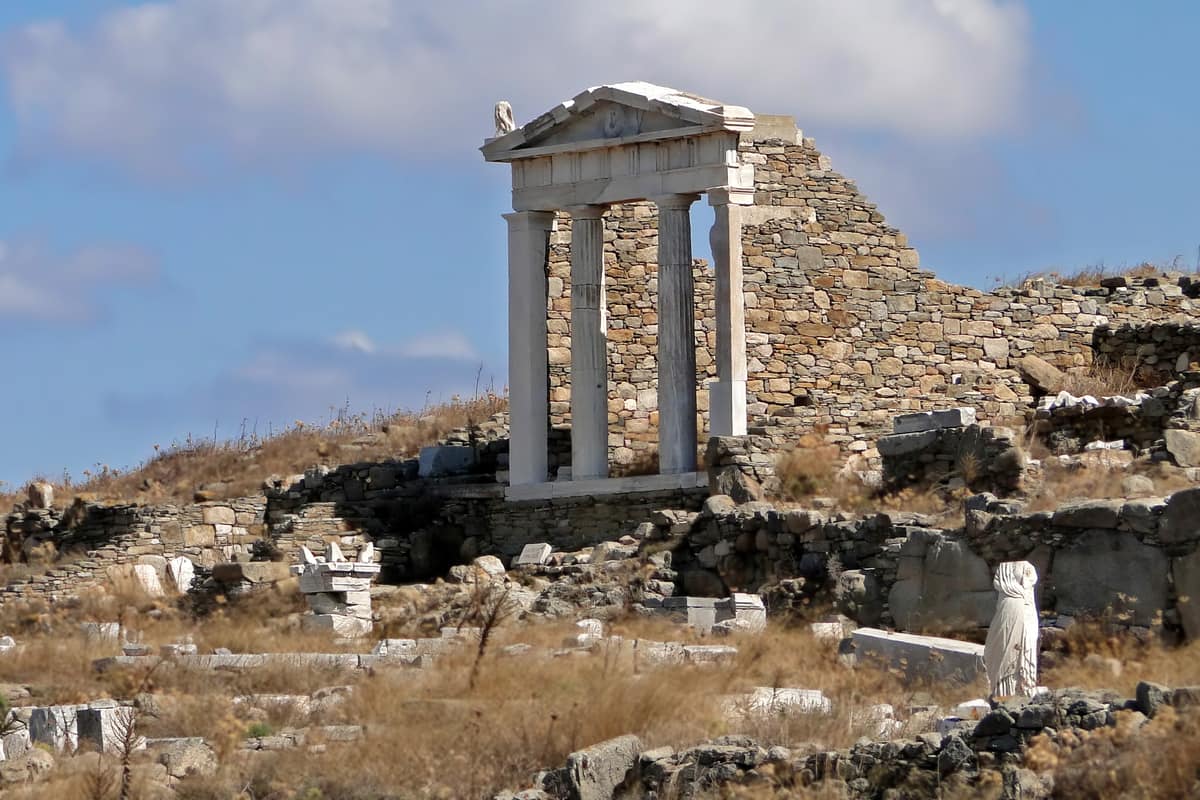
Delos adds a sacred island of ancient ruins to mykonos greece. The ruins of Delos hold World Heritage status from UNESCO, which cites the exceptional archaeological site. At 3.43 square kilometres in area, Delos is small, and Wikipedia places it near the middle of the Cyclades. Boats cross to it from the old harbour of Mykonos.
Myth sets the birth of Apollo and Artemis on Delos, the national tourism board explains. For that reason no mortal was allowed to be born or die there. Women about to give birth, and people near death, went to nearby Rhenia. A boat from mykonos greece reaches an island where, the page says, no one is born or dies.
Old stone huts point to settlers in the third millennium BC, Wikipedia states. Between 900 BC and 100 AD it was a major cult centre. The French School of Archaeology began digging there in the nineteenth century. Tourism on mykonos greece grew partly because of that work.
The Terrace of the Lions was a gift from Naxos to the god Apollo. It dates to a little before 600 BC. Nine to twelve marble lions first lined the Sacred Way. One lion was removed; the Venetian Arsenal now has it over its main gate. From mykonos greece, a short crossing reaches this avenue of lions.
The House of the Dolphins is named for an atrium mosaic of erotes, the love gods, riding dolphins. The House of Dionysos is named for a mosaic floor that shows Dionysus on a panther. The mosaics article says about half of the surviving tile mosaics of Hellenistic Greece come from Delos.
Wikivoyage lists a theatre that seated between 3,000 and 5,000 spectators. Cleopatra’s House, built in the second century BC, is named for two headless statues found inside. From the top of Mount Kynthos, the same page describes a panoramic view of the surrounding islands. All of it lies within a short sail of mykonos greece.
Overnight stays on Delos are forbidden, so the nearest beds are on Mykonos. The only people there are security staff and archaeologists, Wikivoyage notes. Wikivoyage names a modest gift shop beside the gate as the only shop on the island. The island gives no cover from the sun. Check these points before a trip from mykonos greece.
Which beaches stand out on mykonos greece?
The south side of mykonos greece holds the sheltered beaches, Wikivoyage says, protected from the prevailing northern wind. Its list also covers the east, north and west coasts, from Kalo Livadi and Kalafatis to Panormos and Megali Ammos. The paragraphs below give one plain fact for each beach.
Megali Ammos is the nearest beach to the town, one kilometre south and a ten-minute walk along the coast. According to the page, strong northerly winds leave this sand bare of umbrellas and sunbeds. On this beach of mykonos greece, the wind has shaped the set-up.
On mykonos greece, Psarou lies 5 km from the town. Wikivoyage notes that the beach is popular with Greeks. Hotels, apartments and restaurants stand around the sand. Bus riders get off one stop before the last stop, at Platys Gialos.
Platis Gialos lies 6 km from the town. Its long sandy beach is lined with hotels, apartments, restaurants and beach bars. Wikivoyage notes that jet skis can be rented there. The page names it the starting point for regular boats to the other southern beaches. That makes it the boat hub of the south coast of mykonos greece.
Elia lies 8 km from the town and ranks among the larger beaches on mykonos greece. Wikivoyage describes it as well organised, with sunbeds, umbrellas, water sports and three restaurants and taverns. Agrari is its calmer neighbour. The page calls Agrari less popular than Elia and gives the walk over the rocks as 5 minutes.
A long, quiet stretch of sand marks Kalo Livadi in the east. Mykonos Town is 10 km away, and Ano Mera only 2 km. On the east side of mykonos greece, Wikivoyage prefers your own transport but confirms a bus route. The route is the bus to Elia, then about ten minutes downhill on foot.
Kalafatis lies 12 km from the town and is a very large, less developed beach. Wikivoyage names the offshore breeze as the reason windsurfers like it. The sandy beaches of Draoumia and Tafarnis sit directly beside it. For sport on the water, the east side has a clear draw.
On the north coast, Panormos Beach faces east onto Panormos Bay. Wikivoyage calls it long and says two restaurants, one hotel and a beach club serve an otherwise remote area. A traveller needs their own transport to reach it. The north side of mykonos greece is the remote side, as the page tells it.
Which villages and monasteries show the quiet side of mykonos greece?
At Ano Mera, the monastery of Panagia Tourliani opens the quiet side of mykonos greece. Wikivoyage dates its foundation to the sixteenth century and names it the highlight of the village. Remote beaches, a small settlement, a short coastal walk and a working lighthouse follow.
Ano Mera is built round a large square, with tavernas along three of its sides. The northern bus depot of the town runs a regular service there, as the Wikipedia article on the island notes. For a visit inland, mykonos greece offers this village with its monastery.
Agios Sostis faces east on Panormos Bay. Wikivoyage counts it among the remote beaches of the island, with no rental loungers or umbrellas and no accommodation. The page adds a very good small restaurant. Reaching this corner of mykonos greece takes your own transport, along the road beyond Panormos beach.
Fokos is a small beach with coarse sand and no sunbeds or umbrellas. Wikivoyage points to a very good tavern and tells drivers to follow the signs from Ano Mera. Lia, in the east, is uncrowded and sandy, with tiny fishermen’s houses and two taverns. Walkers can reach Lia from Kalafatis.
Ftelia faces north, so the summer wind makes it good for windsurfing, not for swimming. Wikivoyage describes it as isolated and tranquil, and says wind and dust keep the crowds thin in July and August. A winding road leads down to it. Kapari is a small beach behind the chapel of Agios Ioannis, with a steep walk downhill.
Wikivoyage names Agios Ioannis as the location of the film Shirley Valentine. The page says its small beach does not fill up, and snorkelling is possible there. The view runs across the water to Delos and Rhenia. The village shows the small scale of life away from the town on mykonos greece.
Wikivoyage rates the walk from Platis Gialos to Paranga as easy, at about 15 minutes. On the way lies Agia Anna, a small golden-sand cove with a handful of rental umbrellas. A second travel page calls the cove quiet and relatively undeveloped. Walkers on mykonos greece can link coves this way.
Armenistis Lighthouse is a fully working lighthouse and a mark of the maritime history of the island. From Chora it is 6.5 km to the lighthouse. The place name Fanari translates as lantern. Discover Greece names it a sunset spot. Wikipedia lists it among the landmarks of mykonos greece.
Which foods, drinks and crafts belong to mykonos greece?
The table of mykonos greece rests on cheese, cured pork and fresh fish. Wikipedia lists two local specialities: the cheese Kopanisti Mykonou and the cured meat louza. Travel pages add herb sausages, an onion pie and freshly caught seafood. Ouzo is the drink, and jewellery and galleries are the crafts.
Kopanisti is the cheese to know in mykonos greece. Wikipedia lists it as a PDO cheese, salty and spicy in taste. Cheesemakers on Mykonos have worked this recipe for over three centuries, the same article records. Repeated kneading while the cheese ripens gives it a peppery bite.
A simple dish shows the cheese at work. Wikipedia describes mostra as dry bread topped with the cheese, tomatoes cut small and olive oil. The same page adds that islanders serve kopanisti as a meze with ouzo, the Greek drink. That pairing gives the table of mykonos greece a drink to match.
Louza is the meat to know. One tourism page describes it as cured pork, and Wikipedia likens it to the lountza of Cyprus. The tourism page also lists Mykonian sausages flavoured with herbs, plus an onion pie. These dishes give mykonos greece a hearty side next to its seafood.
The sea supplies the rest of the table. The tourism page calls freshly caught seafood plentiful in the traditional tavernas of mykonos greece. Wikivoyage names stamnagatha, a local wild vegetable served in season. Both pages point to plain village food, so ask a taverna what is in season.
Farms stand behind these foods. The tourism page mentions cheesemakers, bee farms and other producers in the rural parts of mykonos greece. It lists honey among the local products and says the island holds dairies and farmsteads that supply local ingredients.
Crafts and jewellery sit in the town. One tourism page lists boutiques selling jewellery, clothes and crafts along the lanes of mykonos greece. Wikivoyage lists art works, souvenirs and pieces by Greek jewellers among the goods on sale. It adds that a large artists’ colony supports a number of galleries with original works.
Plan the shopping around the clock. Wikivoyage reports a midday pause for shops, from 14:00 to 17:00, while tourist shops keep late evening hours. The page also notes that the town has no department stores. A visitor to mykonos greece finds small boutiques instead.
When do travellers visit mykonos greece, and what do they pack?
Warm weather reaches mykonos greece in late spring and holds into mid-October. Wikivoyage rates those months sunny enough to enjoy beach days. July and August draw the heaviest crowds, so the weeks around them feel calmer. Pack shoes for stone lanes, sun cover and a light jacket for the wind.
Wikivoyage names July and August as the crowded months of mykonos greece. It lists late spring through June, and September through mid-October, as the calmer windows. One tourism page gives nearly the same pair: late spring with June, or mid-September with early October.
Early spring is thin. Wikivoyage expects a limited choice of restaurants and shops in March and April. The ones that close for renovation reopen in late spring. The page adds that public transport and sea routes are scarce out of season. A visit then asks for a flexible plan.
Wikipedia gives the island an average summer day high of 27 degrees Celsius and summer nights above 24. Wikivoyage names 30 degrees by day and 22 by night for July and August. The two pages count different spans, so read both as a rough range for mykonos greece.
Rain marks the cooler half of the year in mykonos greece. Wikipedia counts October through March as the rainy season. Wikivoyage expects showers between October and April and notes that rain in summer is rare. During July and August the steady meltemi wind takes the edge off the heat.
Start the packing with shoes. One tourism page describes cobbled alleyways in the town of mykonos greece. Every visit is a long walk on stone, so choose shoes with a firm, flat sole. They also suit the walk down to a harbour or a beach.
Next comes sun cover. Wikipedia calls the summer days dry and sunny. Put a hat, sunglasses and sun cream into the day bag before you head out in mykonos greece. The wind softens the heat, but it does not replace the cream.
Last comes a light jacket for mykonos greece. Wikipedia describes mild winters, and sunshine still turns up in the middle of that season. Wikivoyage warns that the sea between the islands can get choppy. On a boat deck, a windproof layer keeps the chill away.
How do travellers reach and move around mykonos greece?
Travellers reach mykonos greece by air or by sea. Only 4 kilometres separate the airport from the town. Boats sail from Piraeus and Rafina to two ports on the island. Wikipedia and Wikivoyage describe both routes, and each depends on the season. Buses, taxis and rentals then carry travellers around the island.
Wikipedia names the airport Mykonos-Manto Mavrogenous Airport, code JMK. It has served the island since nineteen seventy-one. Flights link mykonos greece with domestic and European cities. Outside the peak season, connections and operating hours are limited, as the page states.
Four pages give four flight times from Athens. Wikipedia gives 25 minutes, Wikivoyage 35, and two tourism pages 40 and 45. All describe a short hop. Wikivoyage adds that daily flights also come from Thessaloniki in summer.
A taxi service stands ready outside the terminal day and night, per Wikipedia. The drive into the town then takes roughly ten minutes. The page adds that the airport bus runs only in summer. Wikivoyage describes a walk of 2.5 kilometres, with a pavement for much of the way.
Daily boats link Piraeus and Rafina with mykonos greece, and Wikivoyage counts both ferries and fast catamarans among them. A Piraeus crossing lasts 3 hours 30 minutes at the quickest and 5 hours 15 minutes at the slowest. The Rafina trip lasts 2 hours 10 minutes when quick and 5 hours 30 minutes when slow.
A fast catamaran takes about half the time of a slow ferry, the page adds. A traveller landing at Athens airport is better off sailing from Rafina. In Piraeus it places the high-speed boats at Port Gate E7 and the conventional ferries at Port Gate E1. Schedules differ, so check the timetable of the day.
The page lists boats more than once a day from Syros, Andros, Tinos and Paros. Naxos, Ios, Santorini and Crete have daily links. Booking ahead matters between mid-July and late August, and around Greek holidays, the page says.
Wikivoyage splits the boat traffic of mykonos greece between the old harbour and the newer port at Tourlos. The Tourlos port stands roughly 2 kilometres from the town, to the north. The page places the fast catamarans at the old port and the bulk of the ferries at the new one. Check the port before you travel.
Wikivoyage describes the shoreline walk between the old port and Chora as brief and simple. Wikipedia lists a bus depot there with buses to Tourlos and Agios Stefanos. Wikivoyage calls summer cancellations for strong wind very rare, a handful of days a season. Winter sailings are irregular.
Buses cover mykonos greece from two stations on opposite sides of the town, Wikivoyage explains. No bus links them, and going on foot from one to the other needs about 20 minutes. The southern station serves Platys Gialos, Paraga, Ornos and Agios Ioannis. The northern one serves the east. Timetables change about every two weeks.
Taxis are scarce. Wikivoyage counts only about 30 on the whole island, and evenings are the hardest time to find one. For the north coast beaches, the page names a rented motorbike or car as the way to go. Narrow roads with sudden twists ask for driving experience on a motorbike or quad bike.
What else do travellers ask about mykonos greece?
Who is the pelican of mykonos greece, and where does it live?
Petros is the pelican of mykonos greece. The bird was a great white pelican, says Wikipedia, and the island’s official mascot. Wikivoyage places the find off Paranga shore, following a storm in the nineteen fifties. The islanders nursed the bird to health, and it stayed.
The pelican soon took the name Petros, a joke shared by the locals, per Wikipedia. A car struck the pelican in December of nineteen eighty-five, and he died. Three new pelicans then settled around the main town. One of them was given the name Petros as an honour.
Wikipedia calls Petros an old celebrity of the town’s waterfront. Wikivoyage lists the pelican of mykonos greece among the town sights. It says the bird turns up at the waterfront, or even up in town, only sometimes. No source promises a meeting on a set day.
How can late nights and calm days share one visit to mykonos greece?
Late nights and calm days on mykonos greece run on different clocks. In summer, Wikipedia calls the island an upscale nightlife and party destination. Wikivoyage says bars lead the nightlife, and dance clubs sit beside them. It lists one open-air dance club that runs from 00:30 to 08:30, only in July and August.
The day looks different in mykonos greece. The official Greek tourism page sets glamour beside simplicity and entertainment beside tranquillity. Wikivoyage says the town kept its traditional Cycladic style despite fast growth. Wikivoyage places the harbour at the centre of a wide bay, with the white lanes around it.
Wikivoyage says the island tends to be extremely crowded in July and August. On gay-friendly nightlife, it says Mykonos stayed refined and romantic rather than rowdy. A tourism page places the calm side in the months before and after high summer.
How far do Delos and Tinos lie from mykonos greece, and how does a traveller reach them?
Delos lies close to mykonos greece. Wikipedia puts the two islands only two kilometres apart. The Wikivoyage page on Delos says 3.5 km southwest of Mykonos. The pages differ a little. Wikivoyage says the boat trip takes about 30 minutes.
Wikivoyage says boats run daily except Monday, because the archaeological site is closed that day. In the off-season, boats leave only once a day, at either 09:30 or 10:30. Online information about them is unreliable, so Wikivoyage advises a check at the kiosk in person.
Tinos lies north of mykonos greece. Wikipedia says boats from the ports of Tinos reach Mykonos in 35 minutes. It adds that Andros and Delos are the other islands next to Tinos. Wikivoyage says day trips are possible to Delos and Tinos, and adds that the ferry schedules need a careful check.
How long does a visit to mykonos greece need?
Wikivoyage and Wikipedia set no fixed number of days for a visit to mykonos greece. Wikivoyage calls the island easy to explore on your own and sees no real need for booked excursions. The sources give blocks of time instead.
Delos is one block of time. In high season, Wikivoyage lists three morning boats, the first at 09:00 and the last at 11:00. Three return boats leave at 12:15, 13:30 and 15:00. The excavations open from 08:30 to 15:00, and Wikivoyage advises an early start to see it all.
The town has its own hours. Wikivoyage lists the Aegean Maritime Museum as open daily, 10:00 till 13:00 and 18:00 till 21:00. The archaeological museum opens at 09:00, closes at 16:00 and is shut on Tuesday. Wikivoyage ends with a next step: return to Athens or move on by boat to Paros, Naxos, Ios or Santorini.
What is the windmill count of mykonos greece?
The windmills of mykonos greece number sixteen, counts the Wikipedia article on them. Seven crown the landmark hill in Chora. Wikipedia calls the windmills iconic and says every spot in the main town has them in sight. Wikivoyage says the windmill area looks over Little Venice.
Wikipedia describes one shared design for the mills: white round towers, a pointed roof above and small windows. The Kato Mili row stands on a hill, where it puts the strong northern winds to work. They milled wheat, and Wikipedia calls them important for the income of the islanders.
One of the windmills is now a museum. Inside, Wikipedia says, the museum displays tools and machinery from earlier times. The view takes in the whole town of Chora and part of the harbour. Wikivoyage names the windmill area a popular sunset spot.