
Cyprus island sits in the eastern Mediterranean as a country of its own, so it is not a Greek island, yet its sun, sea and ancient towns make it the eastern chapter beside the tours in Greece on the homepage.
The page covers the land and districts, the story from the first villages to the republic, the Green Line, the towns, the Troodos painted churches and ancient sites, the coasts and nature, food and wine, how to reach the island, the seasons and the day trips.
What is cyprus island, and where does it lie?
Cyprus island is a state of its own in the eastern Mediterranean, facing the Levant coast of West Asia. Only Sicily and Sardinia are larger Mediterranean islands, by area and by population, as Wikipedia ranks them. Europe, Africa and Asia meet around it, at a crossroads of three continents.
On a map, cyprus island lies south of Turkey and west of Lebanon, as Wikivoyage states it. Turkey is 75 kilometres to the north. Lebanon is 105 kilometres to the northeast, and Syria is 108 kilometres. Israel is 200 kilometres to the southeast, and Egypt is 380 kilometres to the south.
Greece lies to the west of cyprus island. Kastellorizo, a small Dodecanese island, is 280 kilometres away. Rhodes is 400 kilometres away, and the Greek mainland is 800 kilometres away. Cyprus is a country of its own and a member of the European Union, not a Greek island. It also belongs to the Commonwealth of Nations.
Wikipedia notes that sources place cyprus island in Europe or in West Asia. Geography of Cyprus puts the island in West Asia, yet it calls the country European in political geography. Geologically, the island belongs to Asia Minor and lies within the Anatolian Plate. The Karpas Peninsula, at the eastern end of the Kyrenia Range, points toward that region.
The classical Greek form of the name is Kypros. In Turkish, the Republic of Cyprus is Kibris Cumhuriyeti. The official English name is the Republic of Cyprus. A person from the island is a Cypriot. These names are good to know when you read a map of cyprus island.
On a globe, cyprus island lies between latitudes 34 and 36 degrees north. Its longitudes run from 32 to 35 degrees east. The island runs on Eastern European Time, set at UTC plus two hours in winter. Summer brings a move to UTC plus three hours. Its telephone code is +357.
The Wikipedia lead adds that the intense Mediterranean climate and rich cultural heritage make cyprus island a major tourist destination. That heritage features both Greek and Turkish elements. The next sections turn to the land, the towns, the past, the sights, the food and the ways to travel.
How big is cyprus island, and what shapes its land?
Cyprus island covers 9,251 square kilometres in total. From end to end it is 240 kilometres long, and at the widest point it is 100 kilometres wide. Two mountain ranges and the central plain between them shape the land, as Wikipedia states. They are the Troodos Mountains, the Kyrenia Range and the Mesaoria plain.
The total includes the north, the United Nations buffer zone and the two British base areas, as Wikipedia states. Geography of Cyprus lists a coastline of 648 kilometres for cyprus island. In world rankings, Wikipedia puts it 80th by area and 51st by population. Coastal lowlands of varying width surround the island.
The Troodos Mountains cover the southern and western parts of cyprus island and fill roughly half its area. The Troodos Massif has a surface layer that is mainly basaltic lava rock. In the centre of the range stands Mount Olympus, which reaches 1,952 metres. No other summit on the island stands higher.
The main Troodos range runs from Pomos Point in the northwest almost to Larnaca Bay in the east. Uplift and folding left the area fragmented, with spurs that branch off in all directions and steep-sided valleys. The Troodos stand out as the single clearest feature in the landscape of cyprus island.
The Kyrenia Range is a narrow limestone ridge that rises suddenly from the plain along the northern coast. Its peaks reach a maximum of 1,024 metres, hardly more than half the height of Mount Olympus. A summit that looks like five fingers gives the range its other name, Pentadaktylos. The writer Lawrence Durrell linked its crags with crusader castles.
Between the two ranges lies the central plain, the Mesaoria, which is open to the sea at both ends. The capital, Nicosia, sits in the middle of this plain on cyprus island. The two ranges run roughly parallel to the Taurus Mountains on the Turkish mainland. The outlines of the Taurus are visible from northern Cyprus.
The Mesaoria was once covered with rich forests, as Geography of Cyprus states. Ancient conquerors needed the timber for their sailing vessels, so little evidence of the woodland remains. Considerable forests still stand on the Troodos and Kyrenia ranges of cyprus island.
No river on the island is longer than the Pedieos, which drains the Mesaoria. Together with the Yialias it runs east into Famagusta Bay, while the Serraghis flows northwest through the Morphou plain. A network of winter rivers starts in the Troodos and fans out around the massif. In summer, all of the rivers on cyprus island are dry.
How is cyprus island divided into districts and towns?
Six districts make up the Republic of Cyprus, as Wikipedia lists them: Limassol, Paphos, Larnaca, Nicosia, Kyrenia and Famagusta. Each district capital shares its district’s name, and Nicosia is the capital of cyprus island and its biggest city. The districts divide into municipalities and communities.
The census table on Wikipedia puts numbers on the main towns of cyprus island. Nicosia has 173,175 people and Limassol has 124,054. Larnaca has 68,194 and Paphos has 37,297. Strovolos has 71,123, Lakatamia has 53,273 and Agios Athanasios has 42,936, so all three are larger than Paphos.
Two counts describe the people of cyprus island. The Republic’s website, as Wikipedia quotes it, gives 918,100 people in the government-controlled areas at the census it cites. Geography of Cyprus lists 1,326,108 people for the whole island, or 138 for every square kilometre. Nicosia is the largest district by population, and Limassol is second.
Nicosia, the capital, lies in the middle of the central plain. Among the capitals of European Union member states, it lies farthest to the southeast. The Nicosia Metropolitan area has seven municipalities and 255,309 people, and it is the largest urban area on cyprus island. The city is divided today, and a later section tells how.
The other district capitals sit by the sea. Limassol lies on the southern coast, Larnaca on the southeast coast and Paphos in the southwest. The southern coast ends in the far east at Ayia Napa, a tourist resort in Famagusta district. Paralimni, in the same district, has 31,709 people. Later sections give each town its own story.
The north has the district towns of Kyrenia and Famagusta. On the northern coast stands the city of Kyrenia. Geography of Cyprus lists 3,355 square kilometres under the administration of the Turkish Republic of Northern Cyprus. Only Turkey recognises it, and its capital is North Nicosia. This is a plain fact of the map of cyprus island.
Two British base areas, Akrotiri and Dhekelia, also lie on cyprus island. Wikipedia places them on the southern coast, and together they cover 254 square kilometres. Geography of Cyprus assigns 5,896 square kilometres of that area to the southern part, which is the Republic of Cyprus. A United Nations buffer zone separates that part from the north.
Who lived on cyprus island in the earliest times?
The first people on cyprus island were hunter-gatherers, who arrived about 13,000 years ago. Farming villages appeared in the ninth millennium BC, with round houses and flocks of sheep and goats. Copper workers came next, and in the Bronze Age the island gained its first towns.
Before people came, only four land mammals lived on cyprus island, among them a dwarf hippopotamus and a dwarf elephant. Both were much smaller than their mainland ancestors. Aetokremnos on the south coast is one of the oldest well-dated sites of the hunters. Its finds suggest they took those two animals.
The first farmers on cyprus island brought dogs, sheep and goats with them. They built round houses with floors of burned lime, as the digs at Kastros and Shillourokambos show. Plant remains from the early villages show cereals, lentils, beans and peas. The oldest evidence of farming dates to the ninth millennium BC.
Archaeologists in the west of cyprus island found water wells that are 9,000 to 10,500 years old. They count among the oldest wells in the world. A grave of about the same age held a cat, buried beside its owner and estimated at 9,500 years old. Both finds come from the Stone Age.
The Stone Age on cyprus island ended as copper came into use. A copper chisel found at Erimi on the south coast is the oldest copper find on the island so far. A stamp seal and graves with rich goods suggest that wealth was gathering in certain families.
In the third millennium BC, people from Anatolia reached cyprus island and began the Bronze Age. Archaeologists call their way of life the Philia culture. They knew how to work copper, so they moved to the foothills of the Troodos mountains. Their era also brought the plough, the loom and the donkey, and cattle returned.
Copper mining on cyprus island led to wide trade, and ingots shaped like oxhides have been found in shipwrecks. The oldest copper workshops found so far lie at Pyrgos-Mavroraki, 90 km south-west of Nicosia. Enkomi, near modern Famagusta, was the chief harbour town. Egyptian, Hittite and Assyrian texts call the land Alashiya.
How did the ancient kingdoms shape cyprus island?
The ancient kingdoms of cyprus island were ten city-states, named in an Assyrian inscription of the seventh century BC. Six stood on the coast and four inland. Each had its own king, and the tributes, alliances and rivalries of these kings drove the history of the island.
The coastal kingdoms were Salamis, Kition, Amathus, Kourion, Paphos and Soli. Tamassos, Ledra, Idalion and Chytri lay inland. Later inscriptions add Marion, Lapithos and Kyrenia. Names such as Paphos, Kourion and Kyrenia are still on the map of cyprus island today.
Greek writers told that heroes of the Trojan War founded towns on cyprus island. Teucer was said to have founded Salamis, and Agapenor of Tegea to have founded Paphos. Mycenaean Greeks settled in waves at the end of the second millennium BC. Literary evidence also points to Phoenician traders from Tyre at Kition by the tenth century BC.
The royal tombs of Salamis show the wealth of the eighth century BC. Their burial passages held horses, chariots, bronze cauldrons and ivory beds. The tombs were plundered, yet the finds were rich. Funeral customs there echo the poems of Homer, and trade on cyprus island ran east and west.
The main goddess of the kingdoms was Ishtar, called Astarte by the Phoenicians and later Aphrodite by the Greeks. Homer calls her the lady of Kypros. The King of Paphos served as her high priest, and a great pilgrim temple stood at Palaepaphos. Pictures of Aphrodite also appear on the coins of Salamis.
Assyria claimed cyprus island first. A stele found at Kition records the victory of Sargon II over seven kings in 709 BC. The kingdoms won freedom when the Assyrian empire fell in 609 BC. Egypt held the island for about 25 years, and Persia took it in 545 BC. The kings kept their thrones and paid tribute.
Alexander the Great won at Issus in 333 BC. The kings of cyprus island then turned on Persia and gave their ships to his fleet. Cypriot ships and engineers helped him take Tyre. After his death, his successors fought over the island. From 294 BC the Ptolemies of Egypt held it until 58 BC.
Under the Ptolemies the older local languages died out, and the Greek alphabet replaced the Cypriot script. Ptolemy II founded the city of Arsinoe between Old Paphos and New Paphos. Zeno, who later founded the Stoic school in Athens, was born at Kition about 336 BC.
How did Rome and Byzantium rule cyprus island?
Rome took cyprus island in 58 BC and ruled it as a province, with Nea Paphos as the capital. Christian tradition says that Paul and Barnabas brought their faith to the island in the first century. After the Roman Empire split, Byzantium governed the island, later sharing it with the Arabs.
Cato the Younger was sent to annex cyprus island in 58 BC. Mark Antony later gave the island to Cleopatra of Egypt. In 31 BC the fight at Actium put the island back under Roman rule. From 22 BC it was a senatorial province without a standing army.
Rome split cyprus island into four districts: Salamis, Paphos, Amathus and Lapethos. Nea Paphos was the capital until Salamis rose again as Constantia during the fourth century. The island kept a large amount of autonomy and stayed mainly Greek in culture. No Roman colonies were founded there.
Christian tradition says that Paul, Barnabas and John Mark landed at Salamis during the first century. They went on to Paphos, where they met the Roman governor Sergius Paulus. As the Acts of the Apostles tell it, he became a believer. So cyprus island belongs to the early story of the Church.
Bishops from Salamis, Tremithus and Paphos took part in the Council of Nicaea in the fourth century. In the fifth century the Church of Cyprus became independent of the Patriarch of Antioch at the Council of Ephesus. Emperor Zeno also gave the archbishop the right to carry a sceptre instead of a staff.
Earthquakes shook the island in the fourth century. One destroyed Salamis and Paphos, and a later one destroyed Kourion. Salamis was rebuilt as a smaller Christian city. At Kourion, builders took stone from the ruins to raise a basilica in the style of the fifth century.
The early churches of cyprus island had mosaics. At Kopetra in the Vasilikos valley, three Late Roman churches have been found. The dome over the sanctuary of the largest once held a colourful glass mosaic. The Kourion basilica kept the remains of a mosaic between the windows of its sanctuary.
Arab forces landed on cyprus island in the middle of the seventh century. Late in that century, the Byzantine emperor and the caliph agreed to share the island. This shared rule lasted for about three hundred years. In the tenth century Byzantium took the island back as a province called a theme. The crusaders came in the twelfth century.
How did the Lusignans and Venice rule cyprus island?
Lusignan kings, a French family, ruled Cyprus island from the end of the twelfth century. Venice took over in the late fifteenth. Richard I of England had won the island during the Third Crusade and sold it a year later. Both powers left towns and walls that visitors still see.
Richard I of England came ashore at Limassol during the Third Crusade, and the history of Cyprus island changed course. A storm had parted the ship of his sister and his bride from the fleet. Richard forced the Byzantine governor, Isaac Komnenos, to flee. He married Berengaria at Limassol, and she was crowned queen of England there.
Richard sold the island to the Knights Templar, who passed it on to Guy of Lusignan after a revolt. Guy’s brother Aimery followed him and received the royal crown from the Holy Roman Emperor, Henry VI. In this way the Kingdom of Cyprus began, with Nicosia as the seat of its kings.
The first Lusignan kings made Latin the official language of Cyprus island, and French replaced it later. Greek was recognised as a second official language much later still. The Orthodox Church kept its own archbishop, but the Latin Church held more standing and property. Over time more Greek Cypriots rose into the upper classes.
Nicosia was the seat of the Lusignan kings and of the Latin Church. Builders raised the first city walls there. Palaces and public buildings rose too, such as the Gothic Cathedral of Saint Sophia. After the fall of Acre, Cyprus island became the centre of European trade with Africa and Asia.
In the fourteenth century, Genoese merchants came to dominate the kingdom. The Mamluk Sultanate then forced the kingdom to pay tribute, at the start of the fifteenth century. After the death of James II, the last Lusignan king, his Venetian widow Catherine Cornaro reigned as a figurehead. Venice formally annexed Cyprus island after she gave up the crown.
Venice used the island as a trading hub, while Ottoman raiders struck it frequently. After the Ottomans destroyed Limassol, the Venetians also fortified Famagusta and Kyrenia. In Nicosia they pulled down the old walls and built new ones. They also diverted the Pedieos river to fill the new moat. Shakespeare set Othello on Cyprus island in this Venetian age.
How did the Ottomans and the British rule cyprus island?
Ottoman rule of Cyprus island lasted over three centuries, from the later sixteenth century to the late nineteenth. Britain then took over the running of the island, first on lease. It annexed Cyprus in the First World War and ruled until independence in the nineteen-sixties.
The Ottoman army landed in July, and the war with Venice decided the fate of Cyprus island. Nicosia and Famagusta met the assault with stiff resistance. Nicosia fell after a siege of forty days. The island then became a province of the Ottoman Empire, and it stayed one until the late nineteenth century.
Soldiers from the conquering army settled on the island, and peasants and craftsmen came from Anatolia to join them. A Muslim community took shape, the first major change in the island’s population since ancient times. By the early eighteen-seventies Cyprus island held 144,000 people, of whom 100,000 were Christians and 44,000 Muslims.
The Ottomans ended the feudal system. They applied the millet system, under which non-Muslim peoples were governed by their own religious authorities. The head of the Church of Cyprus led the Greek Cypriots and spoke for them to the officials. After the sixteen-seventies, the island was at different times a sub-province, a province and a fief of the Grand Vizier.
Under the Ottomans, Cyprus island remained a trading land. Cyprus was rich in salt, sugar, cotton and grain. The island also passed on trade between Syria and Venice. Merchants imprisoned during the war were freed and got their goods and ships back. Venetian consuls stayed on the island to protect traders.
In the late nineteenth century, the Russo-Turkish War and the Congress of Berlin brought a change. Britain took over the running of Cyprus island under the Cyprus Convention. The island was leased, so it stayed Ottoman land on paper. In return, Britain promised to use it as a base to protect the Ottoman Empire against Russian attack.
When the Ottoman Empire joined the First World War against Britain, Britain formally annexed the island. In the early nineteen-twenties Turkey gave up all claims to Cyprus in the Treaty of Lausanne. Britain declared the island a crown colony soon after. Famagusta harbour, finished in the early twentieth century, made Cyprus island a naval outpost overlooking the Suez Canal.
How did cyprus island become a republic?
Cyprus island became a republic in the summer of nineteen-sixty, when British rule ended. The new constitution shared power between the Greek Cypriot and Turkish Cypriot communities. Archbishop Makarios III became the first president, and Fazil Kucuk the vice-president. Each was chosen by his own community.
By the nineteen-fifties the two main communities hoped for different futures. Greek Cypriots wanted union with Greece, called enosis, which became a Greek national policy. Turkish Cypriots first favoured continued British rule and later called for the island to be divided. This disagreement shaped how Cyprus island reached independence.
Midway through that decade, the armed campaign of EOKA began, seeking union with Greece. At the same time, Turkish Cypriots formed the group TMT, which called for partition. Talks in Zurich and London then settled the terms of independence for Cyprus island. The republic followed in the summer of nineteen-sixty.
The constitution made Cyprus island a presidential republic. It set up three independent branches: the government, the House of Representatives and the courts. The president was a Greek Cypriot and the vice-president a Turkish Cypriot. Each held a veto over certain decisions. Large towns got separate municipalities for the two communities.
The shared system soon led to legal deadlock and discontent on both sides. Violence between the communities followed in the early nineteen-sixties. The United Nations sent peacekeepers in the middle of that decade, and they are still on Cyprus island. Nicosia was divided by the Green Line at that time.
In the middle of the nineteen-seventies, Greek Cypriot nationalists and parts of Greece’s military government staged a coup. Turkish forces landed five days later and stayed in the north after a ceasefire, which left the island divided. In the early nineteen-eighties the north proclaimed a state of its own. These events still shape the politics of Cyprus island.
Today Cyprus is a presidential republic. The people elect the head of state for five years. The House of Representatives makes the laws. The post of vice-president, reserved for a Turkish Cypriot, has been vacant since the events of the nineteen-seventies. Together with nine other countries, Cyprus island entered the European Union at the start of the current century.
What does the Green Line mean for a trip across cyprus island?
A strip of land patrolled by United Nations peacekeepers, called the Green Line, crosses cyprus island. Wikipedia gives its length as 180 kilometres, with Paralimni at the eastern end and Kato Pyrgos at the western end. A visitor meets it at the crossing points and as a line through the middle of Nicosia.
The strip covers 346 square kilometres, as Wikipedia states. The width varies a great deal: the narrowest points measure under 20 metres, and the widest stretch passes 7 kilometres. A trip across cyprus island meets this strip in the capital and in the countryside. Among European capitals, Nicosia is the one that is still divided, says Wikipedia.
The Green Line got its name on cyprus island at the end of nineteen sixty-three. After the intercommunal violence of that Christmas, a cease-fire line was agreed. The line was sketched in green pencil by a British general, and the colour gave the zone its name. The cease-fire of August nineteen seventy-four widened the zone again.
The zone is also a place where people live. Wikipedia puts the number at about 10,000, in villages and on farms. It names four villages: Troulloi, Athienou, Deneia and Pyla. Pyla is one of the last villages where members of both communities still live together. Parts of the zone stay untouched, so plants and animals shelter there.
Wikipedia says traffic across the zone was very limited until two thousand and three. It names three crossings in the capital of cyprus island: Ledra Palace, Ayios Dhometios and Ledra Street. Ledra Palace lies just outside the old walls on the west side. Ledra Street reopened as a crossing in the spring of two thousand and eight.
Two government travel pages set out the rules for cyprus island. The Government of Canada page says crossing is allowed only at designated points and is illegal elsewhere. The UK government page says any crossing point can take you from north to south and back. Wikivoyage says passports are not stamped at the crossings but are still required.
Language and names change in the north of cyprus island. Turkish is the mother tongue of Turkish Cypriots, and English is understood less widely there. Nicosia is Lefkosia in Greek and Lefkosa in Turkish. Wikivoyage advises that a taxi driver in the north hears "Ledra" as the Ledra Palace crossing. It calls the situation peaceful for a traveller.
What does Nicosia show on cyprus island?
Nicosia is the capital of cyprus island. Wikipedia counts more than 5,500 years of continuous settlement on the site. Its old town sits inside round Venetian walls with eleven bastions. The Green Line cuts through the walled town as well, so the walls lie on both sides of it.
Nicosia keeps the Venetian age of cyprus island in stone. Venice rebuilt the walls in the sixteenth century, and they form a circle about 5 kilometres around. The eleven pentagonal bastions carry the names of Italian noble families that gave money for the work. Half of the walls lie in the north, and Flatro Bastion lies in the buffer zone.
Three gates lead through the walls. The Kyrenia Gate opened the way north to Kyrenia. Roads to Famagusta, Larnaca and Limassol left through the Famagusta Gate. The Paphos Gate faced west. All three are well preserved, as Wikipedia states, and each pointed to a different part of cyprus island. Famagusta Gate also works as an exhibition and concert space.
Ledra Street is about one kilometre long and runs from Eleftheria Square towards the north. It was the busiest shopping street of the capital. Its name comes from Ledra, an ancient city-kingdom that stood where the capital stands now. Onasagorou Street runs parallel to it and is another busy shopping street.
The Archbishop's Palace in the Venetian Revival style stands on Archbishop Kyprianos Square. It looks old, yet the present building dates from the twentieth century. Next to it stands the late Gothic Saint John's Cathedral, built in the seventeenth century. Wikipedia says the cathedral is renowned for its frescoes, a stop for church lovers on cyprus island.
North of the Green Line, Selimiye Mosque occupies the oldest and largest Gothic church still standing on cyprus island. Frankish builders began it as the Latin Cathedral of Saint Sophia. It became a mosque in the sixteenth century, when two minarets were added. Nearby stands the Buyuk Han, an Ottoman caravanserai that is now a cultural centre.
Three museums each add to the story of cyprus island. The Cyprus Museum stands west of the wall, near the Tripoli bastion. Nicosia has one historical museum, the Leventis Municipal Museum. The Ethnological Museum fills a late Ottoman mansion that won a Europa Nostra prize. Wikivoyage advises an early start, as sights in the old town close early.
What does Limassol offer on cyprus island?
Limassol sits on the southern shore of cyprus island, between the ancient city-kingdoms of Amathus and Kourion. Wikipedia locates its historic centre by the Old Port, next to the medieval castle. A seafront walk, a wine area behind the town and a ten-day carnival complete the picture.
Among the towns of cyprus island, Limassol has a name that records its position. Wikipedia traces it to Nemesos, an ancient Greek word for "one found in the middle". It reads that as a reference to the place between Amathus and Kourion. Lemesos, the Greek form, was in use by the tenth century.
The Old Port shows fishing and yachting side by side on cyprus island. Fishing boats mainly use it, since its 250-metre breakwater has room for just three small ships. The Limassol Marina lies 500 metres west of the castle and takes ocean-going yachts. A larger New Port handles the bulk of the commercial and passenger traffic.
Limassol Castle sits beside the old harbour, at the core of the historic town. The castle was rebuilt in the late sixteenth century, under Ottoman rule, over an Early Christian basilica. Its cells held prisoners until the twentieth century, and it is now a medieval museum. The old town keeps Ottoman and British colonial houses from cyprus island's past.
A walk along the water shows the modern side of cyprus island. The Molos is a seaside park, one kilometre in length, built on land won from the sea. Its piers are used for fishing and kayaking. Akti Olympion, a 7-kilometre walking park by the sea, links the Municipal Gardens with the Old Port, says Wikivoyage.
Wine companies in Limassol serve the vineyards on the southern Troodos slopes. Wikipedia says a wine festival takes place in the Public Gardens, with wine tasting, folk dancing and choirs. Eucalyptus, pine and cypress trees grow in the gardens. This wine side links the coast of cyprus island to its mountains.
The Limassol Carnival is a ten-day event before Lent, which Wikivoyage places in February or March. It opens when King Carnival enters the town in a procession, and the first week is Meat Week. The Grand Parade follows on a Sunday along Makariou Avenue, with floats, masked groups and serenaders. Wikipedia calls it the largest carnival on cyprus island.
What does Larnaca add to cyprus island?
Larnaca gives cyprus island a seaside town that grew where Kition, a Greek city-state of antiquity, once stood. It is a district capital on the south-east shore. Its sights are the Church of Saint Lazarus, a palm promenade, a castle and an old aqueduct.
The city-kingdom of Kition began in the thirteenth century BC. Phoenicians rebuilt it at the start of the first millennium BC. Its remains include cyclopean walls, five temples and a naval port. The Stoic philosopher Zeno was born there. Larnaca has a fair claim to be the oldest city on cyprus island.
The Church of Saint Lazarus rose in the late ninth century. Today it belongs to the Orthodox Church of Cyprus. By tradition, Lazarus reached cyprus island and served as the first bishop of Kition. The church rests over what is held to be his second tomb. He watches over Larnaca as its patron saint.
The building is 31.5 metres long and has three aisles. A Gothic stone porch was added on the south side under Frankish and Venetian rule. Later it served Orthodox and Catholic worship together. The carved wooden icon screen is Baroque and gold-plated. On Lazarus Saturday, eight days before Easter, the icon of the saint is carried through the streets.
Finikoudes, Greek for palm trees, is the seafront promenade along Athenon Avenue. A bust of the Athenian general Cimon stands on it. He died at sea in 450 BC, backing an uprising against the Persians who then held cyprus island. The old port quarter is called Skala, the Greek word for ladder.
Larnaca Castle began as a small Byzantine harbour fort and was upgraded in the late fourteenth century. The castle is a museum, and Byzantine wall paintings hang in its central room. The courtyard is a theatre for 200 people. The Kamares Aqueduct, built in the middle of the eighteenth century, watered the town for nearly two centuries.
Its 75 surviving arches stand just outside the town and are lit at night. The salt lake lies to the west, and flamingos spend the winter there. Larnaca is also a gateway to cyprus island, since its airport lies in the nearby village of Dromolaxia. Boats use a seaport and a marina on the shore.
What makes Paphos a landmark of cyprus island?
Paphos is a coastal town in the south-west of cyprus island and the capital of its district. UNESCO listed the ruins of its ancient city at the start of the nineteen-eighties. A medieval castle guards the harbour, and the lower town holds the sea front and the archaeological sites.
Limassol lies about 50 kilometres east of Paphos, and the A6 highway joins the two. Paphos ranks fourth among the towns of cyprus island, behind Nicosia, Limassol and Larnaca. Wikipedia reports the mildest temperatures of any place on the island here. The sea borders the town on one side, while the Troodos Mountains close it in on the other.
Two places on cyprus island carried the name Paphos in ancient times. Old Paphos stood on a hill at modern Kouklia, east of today’s town. Nea Paphos, or New Paphos, was founded beside a natural harbour about 12 kilometres north-west of the old city. Old Paphos was the chief centre of the worship of Aphrodite in the ancient world.
Modern Paphos has two quarters. Ktima, the upper town on the hill, is the main residential district. Kato Paphos lies on the shore around the old port and holds the main archaeological sites. The busiest road, Apostolou Pavlou Avenue, links the quarters from Kennedy Square to the fort. A sea front leads round to the marina.
The west end of the port carries Paphos Castle, a landmark of cyprus island. It is a squat block with a colourful history as a fort and a prison. Its last active use came under British rule. In September the harbour hosts an annual opera, and the castle serves as the backdrop.
Nea Paphos is the ancient city of cyprus island that UNESCO lists. Today the Department of Antiquities runs it as the Paphos Archaeological Park, and the listed area covers about 162 hectares. UNESCO cites its unique testimony to a vanished civilisation. A later section of this page covers the villas, mosaics and tombs of the park.
Paphos holds catacombs from the early Christian era. Saint Solomoni began as one and still keeps frescoes from the twelfth century. A sacred tree at the entrance holds offerings that people hang on its branches. Paphos also shared the title of European Capital of Culture with Aarhus in Denmark. A walker can cover the town itself without a vehicle.
What do Ayia Napa and Protaras offer on cyprus island?
Ayia Napa and Protaras are neighbouring resorts in the far south-east of cyprus island. Ayia Napa holds a monastery from the Venetian era, sandy bays and sea caves nearby. Protaras is quieter and known for Fig Tree Bay. The headland of Cape Greco sits between them.
The resort of Ayia Napa on cyprus island took its name from a monastery of Venetian times. The monastery stands in the middle of the town. In Greek, ayia means holy. Local legend tells of a hunter who came across a Virgin Mary icon hidden in a cave. A monastery then rose around that cave.
The present monastery building comes from the Venetian years of cyprus island, around the close of the fifteenth century. The Thalassa Municipal Museum shows fossils, rocks, ancient finds and sea life. Burial chambers of the Hellenistic and Roman periods, known as the Makronissos Tombs, lie on the coast. Walkers can reach the tombs on foot.
The first tourists came largely from Scandinavia, drawn by the beaches. The water is clear and shallow. Of the resort’s 27 beaches, 14 carry the Blue Flag, more than in any other resort on cyprus island. The town later gained a lively club scene next to its family beaches.
Cape Greco, a headland of cyprus island, marks the southern limit of Famagusta Bay. The headland is a national forest park. The sea caves lie below a cliff, so a viewer looks down on them. The E4 long-distance path follows the coast from Ayia Napa to the caves.
Protaras stretches along Fig Tree Bay on cyprus island and belongs to the municipality of Paralimni. The ancient city-state of Leukolla once stood in this area. Its small, safe harbour gave refuge to Demetrius Poliorketes in 306 BC. Another name for Protaras is the land of windmills.
The club scene is smaller in Protaras than in Ayia Napa. Among the resorts of cyprus island, it has a name for family holidays and for guests from Cyprus itself. Clear, sky-blue water and sand shape its beaches, led by Fig Tree Bay. Ayios Ilias, a small stone church, perches on a rocky crag on the outskirts.
What do Kyrenia and the north coast show on cyprus island?
Kyrenia stands on the northern shore of cyprus island and is known for its old harbour and its castle. Wikipedia states that Northern Cyprus controls the town. A museum inside the castle shows an ancient ship, and the Kyrenia range rises behind the town.
Wikivoyage calls Kyrenia the chief port and tourist resort of Northern Cyprus. The north coast of cyprus island centres on this town. The Periplus of Pseudo-Skylax is the oldest document that mentions Kyrenia. There the place appears as a harbour town, and the text rests on knowledge from the fourth century BC.
Just before British rule, local boats carried wheat, olives, donkeys and goats out of the harbour. Carobs were the main export, and larger boats, mostly from Europe, came for them as autumn turned to winter. A small tower stands in the harbour. A defensive chain was slung from it to close the entrance to enemies.
Kyrenia Castle, a landmark of cyprus island, took its present shape in the sixteenth century. The Venetians then built over a Crusader fortification. The Byzantines had raised the first castle in the seventh century. Richard I of England took it in the twelfth century, on his way to the Third Crusade.
Thick walls, gun ports on three levels and long ramps for hauling cannon show how war changed on cyprus island. The Venetians added them to meet gunpowder artillery. Inside the walls stand a twelfth-century chapel with reused late Roman capitals. The tomb of Admiral Sadik Pasha, the Ottoman conqueror of Kyrenia, lies in the entrance corridor.
One room of the castle on cyprus island holds the remains of a Greek merchant ship. The ship dates from the fourth century BC, and Wikipedia counts it among the oldest vessels recovered. A diver found the wreck in the middle of the nineteen-sixties. Its cargo was 381 amphoras of wine, olive oil and almonds, plus twenty-nine millstones.
Behind the town, the Kyrenia range stretches along the northern coastline of cyprus island. Wikipedia calls it a narrow limestone ridge that rises suddenly from the plains. A summit shaped like five fingers gives it the name Pentadaktylos. Three mountain castles, Saint Hilarion, Buffavento and Kantara, once stood together as a defence against raids on the coast.
What does Famagusta show on cyprus island?
Famagusta sits on the eastern shore of cyprus island, east of Nicosia, and its old centre is walled. Wikipedia says the island’s deepest harbour belongs to this city. The old town keeps medieval churches, and the ancient city of Salamis lies six kilometres to the north.
Famagusta began as Arsinoe, a city that Ptolemy II founded on cyprus island after an earthquake damaged Salamis. He named it for his sister, and the date was about 274 BC. By the third century the name Ammochostos was in use, a Greek word that means Hidden in Sand. The English name grew out of that Greek word.
Wikivoyage dates the walled old centre to the thirteenth century. It adds that the city is a seaport and a resort. In the years of Venetian rule, Famagusta led all the ports of cyprus island. Wikipedia credits its natural harbour and the walls around the inner town for its rise in the eastern Mediterranean.
The walls frame the old town of Famagusta on cyprus island. Mainly Venetian work, the roughly rectangular ring dates from the fifteenth and sixteenth centuries, though parts are older. At first the city had two entrances, named Land Gate and Sea Gate. Wikivoyage counts fifteen towers still standing, with a run of them along the waterfront by the castle.
The Cathedral of St Nicholas, built in the fourteenth century, now serves as the Lala Mustafa Pasha Mosque. Wikivoyage lists a church of the Latins and one of the Greeks, both in poor repair. Such churches show the medieval communities of cyprus island.
A Nestorian church was founded by two Syrian merchants in the fourteenth century. The Ganchvor Church belonged to an Armenian monastery founded in the same century. The Lusignans built the Church of St Peter and St Paul in the fourteenth century. It was later a grain store.
Six kilometres north of Famagusta, the ruins of Salamis show the Roman side of cyprus island. The city stood at the mouth of the river Pedieos. Its Roman cultural centre held baths, a stadium, an amphitheatre, a theatre and a gymnasium. The theatre seated up to 15,000 people. The gymnasium and the theatre have been extensively restored.
Silting of its harbour wore Salamis down. Its people left for Arsinoe, today’s Famagusta, in the seventh century. Varosha, the southern quarter, is a seafront district. It was built up as a beach resort in the nineteen-seventies and then fenced off for decades. Wikipedia notes that Northern Cyprus has since reopened parts of the quarter to visitors.
What is the Troodos range on cyprus island?
No mountains on cyprus island are bigger than the Troodos range, which sits roughly in the centre. Mount Olympus crowns it at 1,952 metres. Pine forests, mountain villages and terraced hillsides fill the range, and its mines sent copper across the Mediterranean for centuries.
Wikipedia traces the range from Pomos Point in the northwest almost to Larnaca Bay in the east. Steep-sided valleys cut its slopes, and in the southwest the mountains step down in foothills to the coastal plain. The rugged range is the dominant feature of the landscape on cyprus island.
The highest point of cyprus island is Mount Olympus, which Greek speakers also call Chionistra. The land of Platres, in Limassol District, takes in both the peak and Troodos Square. Wikipedia lists two explanations of the name Troodos: three roads that climb the mountain, or the mountains of Adonis.
The Troodos massif lifted slowly out of the sea when two tectonic plates, African and European, collided. The same process eventually formed cyprus island itself. Erosion has since exposed rocks and pillow lava that formed millions of years ago. Observations of these rocks were among the evidence behind the theory of seafloor spreading.
Forests change with height. Across the range, the commonest trees are golden oak and Turkish pine. At higher altitudes the forests are led by Anatolian black pine, with junipers beside it. The Cyprus cedar occurs at the highest peaks. Wikipedia names the cedar among the endemic plants of the range.
Mountain weather differs from the coast. At Prodromos, 1,380 metres up, January averages about 4 degrees Celsius and July about 23. Wikipedia notes that temperatures in the range vary somewhat more between day and night than on the coast. On cyprus island, the climate page limits snow to the Troodos Mountains.
Villages sit in the valleys of the range and cling to terraced hillsides. Mountain resorts, Byzantine monasteries and churches stand on the peaks. Later sections take the churches and monasteries one by one. Wikipedia’s gallery shows two waterfalls at Platres, the Millomeris and the Kalidonia, in the hills of cyprus island.
Which painted churches stand in the Troodos range of cyprus island?
One UNESCO listing joins ten painted churches and monasteries of the Byzantine age, all set in the Troodos Mountains. Wikipedia ranks the region among the densest clusters of Byzantine churches and monasteries in the old empire. It is the heart of church art on cyprus island.
The listing covers ten buildings, from small chapels to grand monasteries. UNESCO listed the first nine during the nineteen-eighties, and the church at Palaichori came onto the list afterwards. The ten stand in Kakopetria, Kalopanagiotis, Nikitari, Lagoudera, Moutoullas, Pedoulas, Pelendri, Galata, Platanistasa and Palaichori. A traveller finds them village by village.
Church building in the Troodos region went on for about 500 years, until the sixteenth century. The Byzantine Empire had annexed the island before that. The page on the range adds that builders chose the mountains, far from a coast under threat. So the wall paintings of cyprus island lie among pine forests and valleys.
Every site on the listing shows building elements that the page calls unique to Cyprus. The steep wooden roof with tiles is the clearest. The thirteenth-century chapel of the Virgin at Moutoullas is the earliest example. The page pictures Panagia tou Araka as its example of these roofs on the smaller churches of cyprus island.
Near Kakopetria, Agios Nikolaos tis Stegis is known in English as Saint Nicholas of the Roof. The listing page calls this eleventh-century building the oldest katholikon, a monastery church, still standing on cyprus island. Its nickname comes from a steep timber roof, added at the start of the twelfth century. Frescoes cover its walls across 600 years.
Panagia tou Araka stands by Lagoudera village on cyprus island, on the north-east slopes of Madari. It takes its name from a wildflower, the vetch. The page counts it among the well-known, completely preserved middle Byzantine churches with murals. An inscription names the monk Theodore Apsevdis as the painter, in the final years of the twelfth century.
The rest of the list adds more centuries. The church of Asinou at Nikitari is from the twelfth century. At Pelendri, the Timios Stavros church holds unique fourteenth-century wall paintings. Kalopanagiotis has a thirteenth-century monastery, and Galata a church from the early sixteenth century. Together they span the eleventh to the sixteenth century on cyprus island.
Which monasteries shape cyprus island?
At 1,318 metres, Kykkos Monastery is among the wealthiest monasteries on cyprus island. The monastery looks north-west from the Troodos slopes, 20 km west of Pedoulas. Alexios I Komnenos, the Byzantine emperor, founded this Orthodox monastery around the end of the eleventh century.
No remains of the first monastery survive, and the church was destroyed three times. The present church dates from the eighteenth century. Its feast days fall on the fifteenth of August and the eighth of September. Pedoulas and its painted church lie to the east, within the same mountain region of cyprus island.
According to legend, the icon of the Virgin kept at Kykkos was painted by the Apostle Luke. A protective covering hides the icon. The museum is an integral part of the monastery. The official tourism page says it holds icons, consecrated vessels, manuscripts and Cypriot antiquities. These objects tell the church story of cyprus island.
Machairas Monastery stands about 900 metres up in the Machairas Forest, 40 km from Nicosia. Its founding falls in the closing years of the twelfth century. A legend tells of hermits who cut through plants with a knife, makhaira in Greek, to reach an icon. Its red-tiled timber roof marks a mountain monastery of cyprus island.
Stavrovouni Monastery sits on a rocky peak 750 metres up, 40 km from Larnaca, as the official page states. The place name Stavrovouni stands for the mountain of the Cross. By religious tradition, Saint Helena and the Roman emperor Constantine founded it. Wikipedia calls it the earliest documented monastery on cyprus island.
The monastery of Chrysorrogiatissa honours Our Lady of the Golden Pomegranate. It lies about 820 metres up, 40 km north-east of Paphos. The monk Ignatius founded it in the twelfth century, and the building dates from the eighteenth. The old winery reopened in the nineteen-eighties and uses the monastery’s own vineyards.
The official tourism page expects proper dress in any place of worship, not overly casual. It also expects visitors to ask permission before taking photographs. The official Stavrovouni page adds that men must be appropriately dressed, and women are not admitted. Photography and video are not allowed there. These rules shape a visit to the monasteries of cyprus island.
Which mountain villages show the old life of cyprus island?
Six Troodos villages keep the old life of cyprus island: Omodos, Lefkara, Kakopetria, Platres, Pedoulas and Fikardou. They sit on different slopes, from the north-facing foothills of Kakopetria to the southern side at Platres and Lefkara. Each village below adds a craft, a river, a museum or a church.
Omodos lies in Limassol District, about 40 km from Limassol town. The Monastery of the Holy Cross is one of the oldest in Cyprus and serves as the village church. Its grounds hold a museum of Byzantine icons, a folk art museum and an art gallery. Omodos is also a wine village of cyprus island.
Pano Lefkara, in Larnaca District, sits on the southern side of the Troodos, with cobbled limestone streets. The name joins lefka, meaning white, with ori, meaning mountains. The village is known for lefkaritika lace and silver filigree work. Groups of women work fine embroidery in the lanes, a custom that has lasted for centuries on cyprus island.
The Patsalos residence, rehabilitated by the Department of Antiquities, now holds a museum of embroidery and traditional silverwork. Legend says Leonardo da Vinci bought a lace cloth here in the fifteenth century for the altar of Milan Cathedral. In the early twentieth century, the embroidery of Lefkara was sold all over Europe.
Kakopetria lies 55 km south-west of Nicosia, where the Troodos foothills face north. No village of the Solea Valley on cyprus island stands higher, at 667 metres. In the village the Kargotis and the Garillis meet, and their joined water becomes the Klarios river. The old quarter has sloped tiled roofs and wooden balconies.
Platres sits on the southern side of the range, 25 km north-west of Limassol. It is one of the wine villages of cyprus island. Platres has served as a hill resort ever since British rule began in the late nineteenth century. Nature trails start in the village, and two reach the Caledonia and Millomeris waterfalls.
Pedoulas, in the Marathasa Valley, stands 1,100 metres up and is a summer resort of cyprus island. It has 12 churches, from a fifteenth-century chapel to a cathedral of the nineteen-thirties. The Byzantine Museum near the church of Archangel Michael holds icons and relics from the thirteenth to the twentieth century.
Fikardou, 40 km south-west of Nicosia, is an old settlement on the range’s north-eastern slopes. It has kept its traditional medieval character on cyprus island. The Department of Antiquities owns the village, which is almost deserted. It has been proposed as a candidate for World Heritage status.
What does Kourion show on cyprus island?
Kourion was a Greek city-state on the south-western shore of cyprus island, 13 km west of Limassol. Its acropolis crowns a limestone headland nearly 100 metres tall, beside Episkopi Bay. The ruins include a Greco-Roman theatre, mosaic floors, a stadium and a sanctuary, all near the water.
Greek settlers from Argos arrived here in the twelfth century BC, after the Mycenaean palaces collapsed. The place grew into a kingdom, and under Rome it kept a town government with elected offices, as inscriptions record. The larger share of the ruins dates from the Roman and early Byzantine eras of cyprus island.
The theatre of Kourion began small in the late second century BC. It reached its present size under the emperor Trajan, in the early second century AD. The enlarged seating held up to 3,500 spectators. On cyprus island today, the restored theatre is one stage of an international festival of ancient Greek plays.
The House and Baths of Eustolios stand on the cliff crest above the theatre. The late-fourth-century house holds more than thirty rooms with its baths. An inscription in the entrance hall greets arrivals with a wish of good luck for the house. Mosaics in the courtyard porticoes include a text naming Eustolios as a Christian.
A floor mosaic in the Eustolios baths shows Ktisis, a figure of Creation holding an architect’s ruler. Two panels in the House of the Gladiators show fighters in combat. No other mosaics on cyprus island show gladiators in combat. In the House of Achilles, a partly preserved mosaic shows Odysseus revealing who Achilles is.
The stadium dates to the Antonine period and sits 0.5 km west of the acropolis. Its length was 187 metres, and two round stone posts marked a start line for eight runners. Seating curved around three sides and held about 6,000 spectators. It is the only excavated stadium on cyprus island.
The Sanctuary of Apollo Hylates stands 1.7 km from the acropolis. It served all of cyprus island and ranked third in importance, after the sanctuaries at Salamis and Paphos. Five fourth-century earthquakes struck the town, and the temple fell out of use. Arab raids in the seventh century destroyed the acropolis, and the bishop’s seat moved to Episkopi.
What do the Tombs of the Kings and the Paphos mosaics show on cyprus island?
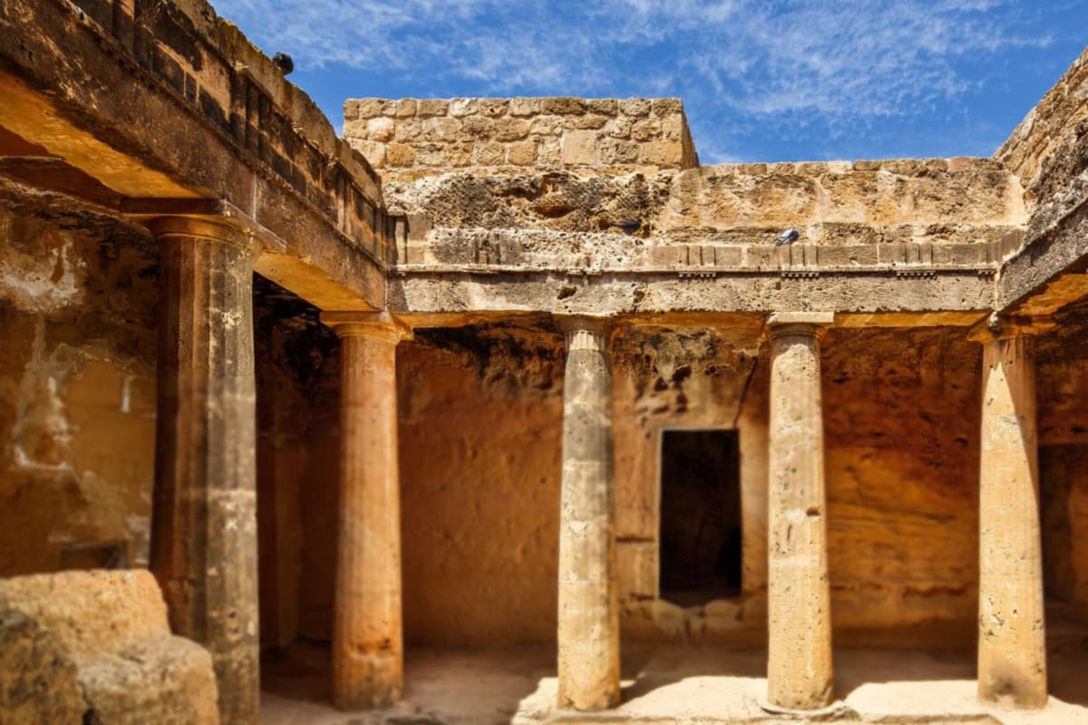
From Paphos harbour, the rock-cut burial ground called the Tombs of the Kings is 2 km to the north. The Paphos mosaics belong to the old port town of Nea Paphos. UNESCO listed both places at the start of the nineteen-eighties, and together they show ancient life on cyprus island.
These rock-cut tombs are among the ancient burial places of cyprus island. Tombs there date back to the fourth century BC. Paphian aristocrats and high officials are thought to have been buried there up to the third century AD. No kings lie there; the name honours their grandeur. Doric columns and painted walls decorate certain tombs.
Old Paphos had a harbour that was unusable. So its last ruler, Nicocles, founded Nea Paphos as a deep-water port late in the fourth century BC. In the second century BC the town became the capital of cyprus island and stayed so under Rome. After earthquakes in the fourth century AD, Salamis became the capital again.
A villa of the third century AD, the House of Dionysos spreads over almost 2,000 square metres. Floor mosaics cover about one quarter of its interior. Along three sides of the atrium runs a border of hunting scenes. The west portico holds four myth panels, among them Apollo and Daphne and Poseidon and Amymone.
The Villa of Theseus on cyprus island was a large home for elites and an administrative building. Its floor mosaic shows Theseus fighting the Minotaur. In the House of Aion, a central panel shows Aion, the deity of time and eternity. Five scenes share one frame there, among them Leda and the Swan.
The Odeon, a half-round theatre of limestone blocks, dates from the second century AD. Its 12 rows of seats held about 1,200 spectators. After restoration it hosts seasonal cultural events. The Cyprus Department of Antiquities runs Paphos Archaeological Park. Areas of the park are open to visitors on cyprus island.
Saranta Kolones means Forty Columns Castle, after granite columns found there. The ruined Byzantine castle on cyprus island is believed to date from the late seventh century AD. It was built to protect the port from Arab raids. Lusignan rulers later changed its design. An earthquake in the early thirteenth century destroyed it.
What does Choirokoitia tell about cyprus island?
Choirokoitia is a Neolithic village site in Larnaca district, set on a hillside in the valley of the Maroni River. UNESCO has listed it since the end of the nineteen-nineties. For cyprus island it shows village life in round stone houses long before the city-kingdoms, in the Neolithic age.
Porphyrios Dikaios, director of the Department of Antiquities, found the site in the nineteen-thirties and led six excavations there. He first placed the village around four thousand BC. Radiocarbon dating later moved its foundation back to around seven thousand BC. A French mission took up the work on cyprus island in the late nineteen-seventies.
A thick stone wall once closed off the village on this hill of cyprus island. The wall is 2.5 metres thick and reaches 3 metres at its highest preserved level. The village probably had entry points through the wall. Apart from the river, the people lived cut off from the world outside.
Inside the wall of this site on cyprus island stood round houses called tholoi. They measured between 2 and 9 metres across. Each group circled an open courtyard, which scholars read as a family unit. The lower walls were stone, with hearths, benches and windows inside. A collapsed flat roof shows that not every roof was a dome.
The villagers grew wheat, barley, lentils and peas. They also herded sheep, goats and pigs, hunted deer and gathered figs, olives and pistachios. Wikipedia calls this the earliest known culture on cyprus island: a well-organised society of farmers, hunters and herders. Burials lay just beneath the house floors, with each body placed in a crouched position.
The village was left suddenly around six thousand BC, for unknown reasons. About 20 other similar settlements spread across cyprus island in the same period. The Greek name has a suggested meaning of pig-cradle, from the words for a pig and a place of origin.
Five round houses have been rebuilt near the settlement. The official tourism page states that they hold replicas of household objects found in the original houses. Native plants and trees that have grown in Cyprus since Neolithic times surround them. A visit to Choirokoitia on cyprus island pairs these rebuilt homes with the original ruins.
What do the castles of cyprus island show?
The castles of cyprus island are medieval forts raised by Byzantines, Lusignans, Venetians and Ottomans. Each one stands in a different place, from a harbour to a mountain ridge. Kolossi, Limassol, Paphos, Larnaca, Kyrenia and Saint Hilarion tell the story from the Byzantine years to the Ottoman years.
Kolossi Castle is a former Crusader stronghold on cyprus island. The castle stands at the edge of Kolossi village, 14 kilometres to the west of Limassol. Large sugar works used local sugarcane there, and medieval Cyprus counted sugar among its main exports. In the early thirteenth century the Knights Hospitaller received the land.
The castle seen today dates from the fifteenth century. The Hospitallers built it under Commander Louis de Magnac, whose coat of arms is carved into the walls. The square keep has three storeys and rises 21 metres. A rectangular enclosure of roughly 30 by 40 metres is attached. The Templars held it in the early fourteenth century.
Limassol Castle is one of the ten castles of cyprus island. The old harbour lies beside it, in the historic core. Excavations beneath it revealed a basilica of the fourth to seventh centuries. A Byzantine monument of the tenth and eleventh centuries lay there too. Ottoman builders finished the present fort in the late sixteenth century.
Paphos Castle closes the western side of the harbour of Paphos. The town lies in the south-west of cyprus island. The castle dates to the middle of the thirteenth century. The Ottomans rebuilt the western tower in the sixteenth century, and a marble slab above the entrance records the work. The British turned it into a salt depot.
The task of Larnaca Castle was to protect the harbour town of Larnaca and the south coast of cyprus island. In the late fourteenth century, King James I upgraded a small Byzantine fort by the harbour. Since independence the castle has housed a museum. Its courtyard is now a theatre in the open air with room for 200 people.
Kyrenia Castle in the north of cyprus island is a sixteenth-century fort, built by the Venetians over a Crusader one. Thick walls, gun ports on three levels and long cannon ramps show how they planned for gunpowder. Saint Hilarion Castle, in the Kyrenia Mountains, controls the pass road that links Kyrenia with Nicosia.
Which museums hold the story of cyprus island?
The Cyprus Museum in Nicosia is both the oldest archaeological museum on cyprus island and the largest. It shows only finds made on the island. Museums in Limassol, Larnaca and Paphos add the districts, and a Byzantine museum in Nicosia adds the icons.
The Cyprus Museum stands on Museum Street in central Nicosia. Only artefacts found on the island are on display. Fourteen halls surround a square central area. That area holds offices, a library, storerooms and laboratories for studying finds. The displays follow the story of cyprus island in time order, from the Neolithic age to Roman times.
The museum began as a petition from the people of cyprus island to the British administration. A delegation led by the Christian and Muslim religious leaders delivered it in the nineteenth century. Illegal digs and smuggling of antiquities had prompted it. The present building was begun in the early twentieth century and finished in the nineteen-twenties.
The icon collection of the Byzantine Museum in Nicosia is the largest on cyprus island. It lies on the grounds of the Archbishop’s Palace, which stands next to Saint John’s Cathedral. A statue of Archbishop Makarios marks the entrance. Wikivoyage dates the works from the ninth century to the sixteenth century.
Limassol has its own Archaeological Museum. The antiquities were found in the district and cover a span from the Neolithic Age down to Roman times. They include stone axes, pottery from Kourion and Amathus, and gold jewellery. The museum began inside Limassol Castle and later moved near the Public Gardens. The castle itself now holds a medieval museum.
The Larnaca District Museum tells the story of Kition and its district, one corner of cyprus island. In the entrance hall, a copy of the stele of Sargon II, king of Assyria, greets visitors. The first room shows Neolithic bone tools and flint knives from Choirokoitia. North of the museum, around 100 metres away, lies the Kition-Bamboula site.
The Paphos Archaeological Museum opened in the nineteen-sixties, shortly after independence. It holds ancient art of cyprus island from the Epipalaeolithic period to late antiquity, found across the Paphos District. The oldest items are tools from hunter-gatherer camps. Finds from the Hellenistic and Roman periods include marble statues, frescoes of Apollo and the Muses, and a reconstructed kitchen.
What does the legend of Aphrodite add to cyprus island?
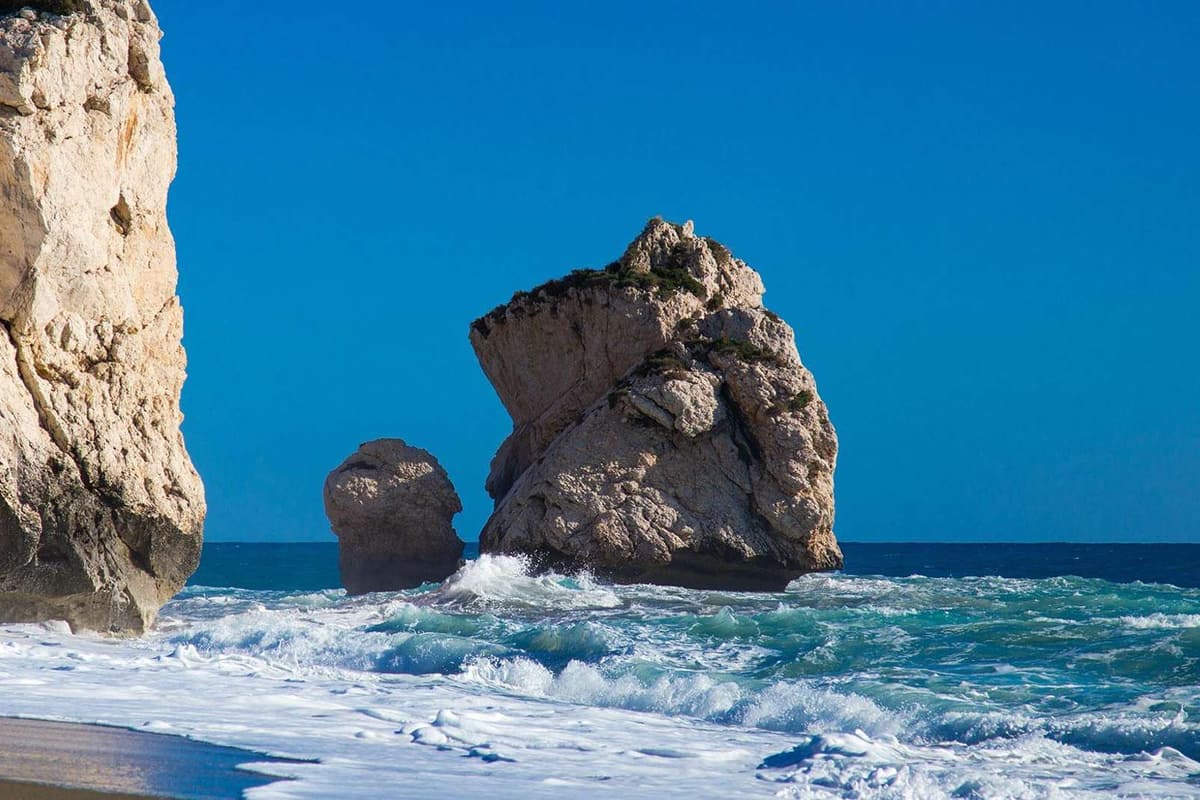
Myth sets the birth of the goddess Aphrodite at a sea stack on cyprus island. The stack is Petra tou Romiou, also called Aphrodite’s Rock. It rises off the shore at Kouklia, beside the main road from Paphos to Limassol. The scenery and the myth make it a popular place to stop.
Hesiod’s Theogony says that Aphrodite was born from sea foam. A local version adds a journey. The waves took the maiden to Kythera and only then brought her to Cyprus. From Cyprus she went on to the assembly of the gods. The Romans knew the goddess of cyprus island as Venus.
The name Petra tou Romiou, Rock of the Greek, belongs to a second legend of cyprus island. The hero Basil of the Digenes Akritas was half Byzantine and half Arab. The tale says that Basil hurled a huge boulder from the Troodos Mountains to hold back the Saracen invaders. A nearby rock is called the Saracen Rock.
Her main sanctuary on cyprus island lay at Palaepaphos, near modern Kouklia and close to the rock. The Sanctuary of Aphrodite Paphia was built in the twelfth century BC. Its open courtyard had a perimeter wall of massive cut-stone blocks. In a hall stood a cone-shaped stone that is thought to have stood for the goddess.
The myths of cyprus island name two founders for the shrine. In the epic tradition, Agapenor, king of Tegea in Arcadia, founded Palaepaphos after the Trojan War. A native tradition credits Cinyras, who is named in the Iliad. His descendants, the Cinyradae, served as hereditary priests at the sanctuary.
Homer’s Odyssey mentions the grove and altar of Aphrodite at Paphos. Later the shrine became a pilgrimage destination across the Mediterranean, set on cyprus island. The geographer Strabo records a yearly procession of sixty stadia between Old Paphos and New Paphos. Worship at the site ended in the fourth century AD, as Christianity spread across the island.
The town of Paphos has its own link to the goddess. King Pygmalion was devoted to Aphrodite, and the goddess brought his ivory statue of her to life as Galatea. Galatea bore him a son called Paphos, as the Bibliotheke tells it. The Kouklia Museum holds finds from Palaepaphos, among them a sarcophagus painted with Homeric scenes.
What does the Akamas peninsula show on cyprus island?
The Akamas peninsula forms the north-western tip of Cyprus island and covers 230 square kilometres. Wikipedia adds one fact that shapes every visit: no roads run through its heartland.
In his description of the cape, Ptolemy saw dense woods and a line of summits that climbs to the north. Akamas, a son of Theseus, gave the peninsula its name. Pegeia marks the southern limit, and Polis looks out from the north-east. Together they frame this corner of Cyprus island.
Roads are scarce here. Certain roads marked on local maps are not sealed, so check the surface before a drive. Until the year two thousand, British forces trained on this land and used a firing range. Today parts of the peninsula hold protected status on Cyprus island.
Gorges cut the peninsula. In the south-west, the Avakas Gorge rises in high sheer cliffs. The walls close in until they touch, and a stream runs through the narrow tunnel that remains. The Androlykou and Petratis gorges lie on the northern side. Both can be seen from the village of Androlykou.
The Department of Forests set up five nature trails here with the Cyprus Tourism Organisation. The official flyer gives about 25 kilometres in all. The Aphrodite trail and the Adonis trail each run for 7.5 kilometres. Near Neon Chorion, a picnic site called Smygies serves walkers on Cyprus island.
The south-western coast holds the Lara and Toxeftra area, 15 kilometres from Paphos. The flyer calls it a marine and coastal reserve of 650 hectares. Of these, 100 are land and 550 are sea. It protects the turtles that nest on its sand. The Baths of Aphrodite lie between Polis and Cape Arnaoutis, with a view over Chrysochou Bay.
Akamas is rich in plants and birds. The peninsula holds 39 of the 128 plant species that grow only on Cyprus island. In Europe, the European Environment Agency lists 22 areas of endemism, and Akamas is one of them. The Department of Forests lists 168 bird species sighted there, along with 20 reptile species.
The flyer also lists rules for visitors. A fire is allowed only for cooking, in the barbecues of picnic and camping sites. If the bins are full or missing, take your rubbish with you. Do not disturb animals and birds, keep noise low, and avoid smoking or eating on the trails. These rules cover the forest land of Cyprus island.
Which beaches stand out on cyprus island?
The beaches that stand out on Cyprus island lie between Ayia Napa in the east and Paphos in the west. Nissi Beach, Fig Tree Bay, Coral Bay, Lara Bay and Governor’s Beach near Limassol are the five names below.
Wikipedia lists 27 beaches at Ayia Napa, and 14 of them won Blue Flag awards. Wikivoyage lists Nissi Beach first. It says the first tourists came to Ayia Napa for these beaches, mostly from Scandinavia. The water tends to be shallow and clear, with a blue-green colour, on this coast of Cyprus island.
Protaras has clear water and sandy beaches. Wikipedia picks out Fig Tree Bay among them, and Wikivoyage adds fine sand with sunbeds and umbrellas. A small islet lies just beside the bay, with a little greenery and rock. A short hiking path starts opposite the bay and ends at Pernera.
Konnos Bay closes Wikivoyage’s list of Ayia Napa beaches on Cyprus island. It is wind-protected, on the border with Paralimni. Cape Greco juts out between Ayia Napa and Protaras. Famagusta Bay ends at this headland in the south. According to the page, no government-controlled land of the Republic lies further east.
Two limestone headlands frame Coral Bay, a crescent of soft white sand with a length of 600 metres. Rocky points and sea caves mark the shore on both sides of the bay. Potima Bay, a second beach, lies about 1.5 kilometres away beside the village of Kissonerga. Both lie north of Paphos on Cyprus island.
Lara Bay opens on the south-west of the Akamas peninsula, 15 kilometres from Paphos. Sea turtles nest on its sand, so the rules differ from those of a resort beach. The official flyer bans umbrellas, sunbeds and cars on the sand of the reserve. Check these rules before a visit to Lara Bay on Cyprus island.
Governor’s Beach lies outside Limassol. Wikivoyage calls it long and sandy, with a white stone coast to the west. Lady’s Mile Beach stretches along the shore beyond the town to the south-west. It is long, mostly pebbly and partly sandy, and Wikivoyage lists it as UK territory. A salt lake nearby leads to the next section on Cyprus island.
What do the salt lakes and wetlands add to cyprus island?
The salt lakes add wide wetlands to Cyprus island. Larnaca Salt Lake is a group of four lakes west of the city. Wikipedia ranks it second among the salt lakes of the island, after the lake at Limassol.
Four lakes make up Larnaca Salt Lake, and three of them link up. Aliki is the biggest. Orphani, Soros and Spiro come after it in size. The four lakes add up to 2.2 square kilometres, and the airport road passes close to them. Salt from the lakes was once a major export, hauled by donkey.
The Wikipedia page calls the lakes one of the important wetlands of Cyprus island. The area is a Ramsar site, a site of the Natura network and an Important Bird Area. It counts 85 species of water birds. The lakes form one of the migratory passages through the island.
In winter the lakes fill with water, and flamingos arrive. Wikipedia puts the winter flocks between 2,000 and 12,000 birds, which feed on brine shrimp. Wikivoyage dates the flocks from November to March. Summer brings dry ground instead, with only a salt crust and a grey dusty haze left. A winter visit to Cyprus island finds the lakes full.
According to a legend, Saint Lazarus requested food and drink from an old woman. The woman declined, pointing out that her vines were dry. Another explanation is geological: the porous rock between the lake and the sea lets salt water seep in. The lake keeps both explanations on Cyprus island.
Hala Sultan Tekke, a mosque and tekke, lies beside the lake on its west bank. Ubada bin al-Samit was a companion of the Islamic prophet Muhammad. The tomb here is that of his wife, Umm Haram. A mosque complex grew around the tomb in stages in the Ottoman period. The complex is a listed Ancient Monument of Cyprus island.
Limassol Salt Lake lies south-west of Limassol, in the Western Sovereign Base Area. It covers 10.65 square kilometres, the biggest stretch of inland water on Cyprus island. It dries out in summer. Thousands of wading birds stop there on the way between Africa and Europe. Estimates put the winter flocks of greater flamingos at 2,000 to 20,000 birds.
Which animals and plants live on cyprus island?
Wikipedia counts about 1,800 plant species on cyprus island. Around 128 of them are endemic, which means they grow wild nowhere else. The island also has over 380 bird species and the Cyprus mouflon as its largest wild mammal. Sharp differences in height, habitat and climate supply a varied home for all of them.
The Cyprus mouflon is the largest wild animal on cyprus island. The animal measures one metre at the shoulder, and its home is the high ground of Paphos District. It is endangered and is the national animal. Wikipedia calls it shy and agile, and says people do not easily approach it on the steep slopes.
Wikipedia counts 21 known mammals on cyprus island, and three of them are endangered. The page also names the large Mediterranean monk seal. The Cypriot mouse is the only endemic rodent left on the Mediterranean islands. The Akamas page adds foxes, hedgehogs, shrews and fruit bats to the animals of the north-western peninsula.
The Cyprus whip snake is one of the harmless, non-venomous reptiles that Wikipedia lists for cyprus island. The blunt-nosed viper is a large exception that lives in the mountains. Wikipedia says the snake is not aggressive, yet a bite from it endangers large mammals, people included. The island also has about 60 species of spiders.
Birds on the move between Africa, Europe and western Asia cross the island. The bird list of cyprus island reaches over 380 species. Two endemic songbirds, a warbler and a wheatear, carry the island’s name. Both breed only here and migrate south for the winter. Akamas holds a Special Protection Area for its birds, and griffon vultures live there.
Forests of pine, cedar, cypress and oak still cover the Troodos and Kyrenia ranges, as the geography article states. Cedar Valley, inside the Paphos State Forest, holds the Cyprus cedar at heights from 800 up to 1,400 metres. Wikipedia names five natural stands of this tree on cyprus island and rates it as vulnerable.
Where the forest ends, shrubs take over: golden oak, strawberry tree, terebinth and olive. Wild flowers on the Akamas peninsula include cyclamen, turban buttercups, the Cyprus tulip and a range of orchid species. The Akamas page puts 39 endemic species on that one peninsula, out of 128 for the whole island.
What do the sea turtles add to cyprus island?
Both the green turtle and the loggerhead nest on the beaches of cyprus island. The Department of Fisheries and Marine Research names both species in its official notice. Females leave the sea at night to lay their eggs on quiet beaches without lights.
Wikipedia says Lara Bay on the Akamas peninsula of cyprus island has a hatchery that protects the turtle eggs. In late spring the department announced that the nesting period had begun. The first nests had turned up on the beaches of Polis Chrysochous. Wikipedia adds that two nesting beaches there became Sites of Community Importance under the Natura scheme.
Alagadi beach on the north coast of cyprus island lies about 30 kilometres east of Kyrenia. Wikivoyage says loggerhead and green turtles nest there. Females lay eggs in June and July, and hatchlings emerge in August and September. The page adds that the beach is closed to the public on summer nights to protect the turtles.
A loggerhead lays an average of four clutches in a season, Wikipedia says. Then it rests for two to three years. Hatchlings dig up through the sand after about eighty days. Darkness improves their chance of escaping predators. They find the sea by heading for the brighter horizon, where moon and starlight shine on the water.
The department states that only one or two of every thousand hatchlings survive. The survivors return to the beach where they were born to breed. That is why the department calls strict protection necessary on cyprus island. Wikipedia lists the Mediterranean green turtle population as critically endangered.
People on a beach can force a female on cyprus island to give up. She then lays her eggs in the sea, and the notice says they are lost. Wikipedia adds that artificial light discourages nesting and interferes with the way hatchlings find the water. The Akamas page lists sea turtles among the vulnerable species of the peninsula.
The official page states the seasonal rules of the Lara-Toxeftra area on cyprus island. They apply from the start of June until the end of September. Umbrellas, beds, tents and caravans are forbidden. So is staying on the beach at night, from one hour before sunset. Fishing is forbidden too, except with a rod from the shore.
The notice also forbids boats to pass or anchor in the protected area up to a depth of 20 metres. That ban starts in late spring and lasts until the end of October. All year, on all beaches of cyprus island, driving a vehicle and lighting a fire are forbidden. So are dropping litter and collecting the protected sand crab.
How do olive, carob and citrus groves shape cyprus island?
Olive, carob and citrus trees grow in the farmland of cyprus island. Wikipedia names potatoes and citrus as the principal export crops and calls the central Mesaoria plain the agricultural heartland. Winter rain, from November to March, feeds the fields, and every river dries out in summer.
The Mesaoria is the broad central plain between the two mountain ranges of cyprus island. Wheat and barley grow there, and their harvest depends on winter rainfall. Other crops need irrigation. Wikipedia says the warm, rather dry climate, with rain mainly between November and March, favours farming.
The farming article says olives and carobs grew without irrigation, like wheat, barley and wine grapes. It adds that olives led the export list of the tree crops. Olive also appears among the wild shrubs of the island, as the geography article states.
The carob tree copes with the dry land of cyprus island. Wikipedia calls it drought-resistant and well adapted to a region with only 250 to 500 millimetres of rainfall yearly. The article adds that carob still grows wild in the eastern Mediterranean.
Carob pods become syrup on cyprus island. Wikipedia describes the method: dried pods are milled and soaked in water, and the juice seeps into containers. It is boiled with constant stirring into a thick syrup named haroupomelo. The article adds that Cyprus exports carob syrup.
According to the farming article, groves of oranges, lemons, grapefruit and tangerines grew along the coasts of cyprus island. Citrus needs irrigation, so these groves depend on water brought to the shore. The article adds that farm cooperatives exported large amounts of citrus fruit.
Wikipedia calls the Cyprus potato long and waxy, with a unique taste, and says it is exported. Two harvests of it came each year, one in winter and one in early spring, the farming article says. Vineyards grow mainly on the Troodos slopes of Paphos District and in the Limassol hills, in the island’s south-west.
Water shapes every farm on cyprus island. Wikipedia describes a chronic water shortage and counts 108 dams and reservoirs. The Southern Conveyor Project moves winter runoff by a main network of 110 kilometres. It was finished in the middle of the nineteen-nineties. Desalination plants have supplied almost half of the water for homes since the first years of this century.
Which foods belong to cyprus island?
Meze is the shared table of Cyprus island. It is a large selection of small dishes, brought out as a progression of tastes and textures. The meal starts with olives, dips and fresh bread. It moves on to fish, grilled halloumi, lountza, sausages and meatballs, and ends with fruit.
Cyprus island counts halloumi as its national cheese. Traditional halloumi is made from a mix of goat and sheep milk, and modern dairies add cow’s milk. The cheese has a high melting point, so it browns in the pan or on the grill without melting. A Venetian official wrote its earliest known description in the sixteenth century.
Beyond halloumi, Cyprus island makes anari, a fresh and crumbly whey cheese close to ricotta. People eat fresh anari in slices with honey or carob syrup. Dry anari is salted and hard, and cooks grate it over pasta. The carob syrup, called haroupomelo, is carob juice boiled down with constant stirring.
Grilled meat sits at the centre of a meal on Cyprus island. Souvla is meat cooked over charcoal and named after its skewers, with pork, kid, lamb or chicken. Sliced onion, cabbage, parsley, tomato and cucumber go into the pita beside the meat. Sheftalia is a lamb or pork sausage with parsley and onion, wrapped in caul fat.
Lountza is pork tenderloin that is brined, marinated in wine and then smoked. Loukaniko is a smoked pork sausage that also rests in wine. Mint runs through the cooking of Cyprus island, in meatballs and in oven macaroni with minced meat and grated halloumi. Bulgur is the traditional starch other than bread.
The sea gives Cyprus island gilt-head bream, sea bass, red mullet, calamari, octopus and cuttlefish. Octopus is stewed in red wine as stiffado. A lemon and olive oil dressing coats the salad vegetables served at every meal. Cyprus potatoes are long and waxy. In early spring artichokes are in season, and diners bite the fleshy base off each leaf.
A meal on Cyprus island ends with fresh fruit or glyka, fruit and nuts preserved in sugar. Bergamot, tiny aubergines, figs and fresh walnuts are cooked into spoon sweets. Flaounes are Easter pastries of cheese, eggs and herbs. Loukoumia, the Cyprus delight, carries a protected European label, and Yeroskipou near Paphos and Pano Lefkara are its main centres.
Which wines and drinks belong to cyprus island?
Commandaria is the sweet, amber-coloured wine of Cyprus island. Two local grapes, Xynisteri and Mavro, dry in the sun first. Fourteen designated villages of Limassol District make the wine. The vineyards lie on the south-facing foothills of the Troodos Mountains, in the south-western part of Cyprus. Wikipedia calls it the world’s oldest named wine still in production.
The name comes from the knights. The Templars kept a large estate at Kolossi, close to Limassol, called La Grande Commanderie. The area under the knights became known as Commandaria, and the wine took the name of the region. A dried-grape wine from Cyprus island is described as early as 800 BC by the poet Hesiod.
Sun-drying for seven to ten days lifts the sugar level of the grapes. Vines must be at least four years old. The law sets two years in oak barrels as the minimum for ageing. The vineyards stand between 500 and 900 metres above the sea. The harvest starts only after the vine products commission gives the green light.
Xynisteri is the local white grape, and Mavro is the dark one; the word means black in Greek. Maratheftiko is an ancient red grape. Wineries use it to show the single character of Cyprus island in a glass. Wine villages of the Commandaria zone include Laneia, Doros, Silikou, Zoopigi and Kalo Chorio.
Better wine grapes grow high in the Troodos, at altitudes of up to 1,500 metres, as Wikivoyage states. These are among the highest vineyards of the European Economic Area. Cyprus island never suffered the vine disease phylloxera. In the late nineteenth century it destroyed the majority of the vines of mainland Europe.
Erimi, near ancient Kourion, holds the Cyprus Wine Museum, which shows jars, drinking vessels and documents from antiquity to today. Italian archaeologists tested pottery pieces from Erimi. Twelve of eighteen carried traces of tartaric acid, a part of wine. So people on Cyprus island used these 5,500-year-old vases for wine.
Zivania is a clear pomace brandy, distilled from grape skins and local dry wine, with a light aroma of raisins. On Cyprus island people serve it ice cold in summer with nuts or small bites. Triantafyllo is a rose cordial made from the Cyprus rose; water or milk turns it into a summer drink.
Which crafts belong to cyprus island?
Pano Lefkara and Kato Lefkara are the two villages behind Lefkara lace, a handmade needle lace. UNESCO has entered the craft on its intangible heritage list. It is the craft to know first on Cyprus island, with silver, weaving and pottery close behind. Women have stitched it in the Troodos foothills for centuries.
The lace has a long place in the story of Cyprus island. The earliest date given for the craft is the fourteenth century. It grew out of an older white embroidery called asproploumia. A lace collection was a centrepiece of a dowry. Each woman had to show a large set on her wedding day.
Stitchers work in white, brown and ecru, with hemstitch, needlepoint edgings and fillings in satin stitch. The signature pattern is potamoi, meaning rivers, built from triangular zig-zags called kamares, or arcs. The first lace used local white cotton. By legend, Leonardo da Vinci bought a lace cloth here for the altar of Milan Cathedral.
Cobbled limestone streets run through Pano Lefkara, on the southern side of the Troodos. A restored house holds the folklore museum, with the furniture of a wealthy family, costumes and lacework. The village also has skilled silversmiths, and Cypriot filigree, called trifourenio, is jewellery made from twisted threads of silver.
Fyti, on a plateau 25 kilometres north-east of Paphos, is the main centre of weaving in Paphos District. The textiles are called Phythkiotika, and they are known for flamboyant colours and a wide range of patterns. A museum of weaving and folk art stands in the village of Fyti, on Cyprus island.
Foini, also spelled Phini, is a Troodos village known for its pottery. It lies near the springs of the Diarizos river. Lapithos, on the north coast, was from ancient times a centre for earthenware and for processing copper. Copper links Cyprus island to language. The Latin word cuprum comes from the phrase aes Cyprium, which means metal of Cyprus.
The north coast adds to the crafts of Cyprus island. The Lapta lace of Lapithos is stitched in cross-stitch on linen. The town also made walnut wood chests for the island and knives with goat-horn handles, known for their sharpness. It is an important silk-producing centre, and its silk goes into handicrafts and weaving.
Which languages shape cyprus island?
Greek and Turkish are the two official languages of Cyprus. Armenian and Cypriot Maronite Arabic are recognised as minority languages. English holds no official status, yet it is widely spoken. Together these tongues shape cyprus island on road signs, in schools and in everyday talk, as Wikipedia states.
Greek Cypriots speak Cypriot Greek in daily life, and Turkish Cypriots speak Cypriot Turkish. Both differ a good deal from their standard forms. For official purposes, standard Modern Greek and standard Turkish are used. A visitor to cyprus island therefore meets a spoken language and a written language side by side.
Cypriot Greek comes from Byzantine medieval Greek, not from the ancient dialect of the island. The page says Arab attacks cut Cyprus off from the Greek-speaking world from the seventh to the tenth century. That isolation gave the dialect of cyprus island its own features. Wikivoyage adds that it holds loanwords from Turkish, Arabic and English.
Cypriot Greek has a long written record on cyprus island. Medieval chronicles by Leontios Machairas and Georgios Boustronios are among its oldest works. In the last hundred years the poets Vasilis Michaelides and Dimitris Lipertis wrote folk poetry in it. Speakers of standard Modern Greek find it unintelligible without prior exposure.
Cypriot Turkish grew from Anatolian roots over four centuries. It blends Ottoman Turkish with the Yoruk dialect of the Taurus Mountains. It has also taken in words from Greek, Italian and English. It is mutually intelligible with standard Turkish. Before the island was divided, Turkish Cypriots were traditionally fluent in Cypriot Greek, a shared everyday tongue.
English was the only official language under British rule and the common language until independence. Road signs, public notices and advertisements across cyprus island still carry it. In Limassol and Paphos, Russian is the third language on shop and restaurant signs, after English and Greek. Wikivoyage places Turkish in Northern Cyprus and Greek in the south.
The constitution recognises three religious groups: Armenians, Maronites and Latins. Two of them have their own language. Western Armenian is taught in Armenian schools, and Armenians have lived on cyprus island since the sixth century. Cypriot Arabic belongs to the Maronites, with the village of Kormakitis as its long-time stronghold. Efforts are under way to revive it.
Which festivals and traditions shape cyprus island?
The festivals of cyprus island follow the church year and the seasons. Orthodox Easter, called Pascha, blends Greek customs with unique Cypriot ones. Fifty days later the Kataklysmos fair marks Pentecost with water. Before Lent, the Limassol Carnival fills the streets with costumes and floats.
Wikipedia describes Pascha as a blend of Greek traditions and unique Cypriot ones. Holy Friday, Easter Sunday and Bright Monday are public holidays on cyprus island. Wikivoyage warns that the Orthodox date differs from Western Europe in the majority of years. It adds that museums close on Easter Sunday and that buses run reduced services in places into Tuesday.
On Holy Thursday, families dye red eggs and begin baking tsourekia and flaounes. On Holy Friday at nine in the evening, the Epitaphios procession crosses the walled old city of Nicosia. It starts in three churches and meets at Eleftheria Square, with the police band playing. These rites mark Easter on cyprus island.
On Holy Saturday morning, worshippers strike the pews to recall the earthquake of the First Resurrection. At night they wait outside church with lambades, lit from the Holy Light flown in from Jerusalem. Bonfires called lampratzia, unique to cyprus island, burn for Judas. After midnight people say Christos Anesti, eat avgolemono and crack eggs in the game tsouggrisma.
Kataklysmos means the days of the flood. The Cyprus National Commission for UNESCO records that the name comes from the custom of sprinkling water. The Larnaca fair, documented since the nineteenth century, is the largest on cyprus island. It fills the Finikoudes promenade with poetry duels, folk dances, sailing races and Karaghiozis shadow theatre.
The Limassol Carnival follows a fixed rule. Its main parade falls on the Sunday before Ash Monday, fifty days before Orthodox Easter. The second week is Cheese Week, and children parade on the first Sunday. Floats and songs are commonly satirical. Wikivoyage calls this event on cyprus island family friendly and says crowds spray each other with string.
Other festivals add music and drama. Paphos hosts an opera performance in the square before the harbour castle at the end of August or early September. Each year Kyrenia stages its own culture and arts festival. Wikivoyage lists the Limassol Wine Festival every September. It also places the Northern Cyprus Music Festival at Bellapais Monastery from mid-September to early November.
How do faiths and communities live on cyprus island?
Eastern Orthodox Christianity dominates religion on cyprus island. Greek Cypriots mainly belong to the Church of Cyprus, and Turkish Cypriots are mainly Sunni Muslims. Armenian Apostolic, Catholic, Protestant and Jewish communities live there too, along with smaller faiths, as Wikipedia states.
The Church of Cyprus is the largest church on cyprus island and one of the oldest autocephalous Eastern Orthodox churches. It gained independence from the Patriarchate of Antioch in the fifth century. It keeps its own archbishop with full administrative autonomy. Its founder is named as the apostle Barnabas. The first President of Cyprus, Makarios III, was an archbishop.
Three religious groups on cyprus island are named in the constitution: Armenians, Maronites and Latins. The Armenian Prelature has served the island since the tenth century. The Armenian compound in Nicosia holds the church of Sourp Asdvadzadzin. Maronites are Eastern Catholics in full communion with Rome. Their ancestors came from the Levant in the Middle Ages.
Limassol has St Catherine's Church, a Roman Catholic church completed in the nineteenth century. A Maronite church there is named for Saint Charbel. The Church of England has been present since the start of British rule. Synagogues stand in Larnaca, Limassol, Nicosia, Paphos and Ayia Napa. Jewish life on cyprus island reaches back to the third century BC.
Turkish Cypriots on cyprus island mainly follow the Sunni branch of Islam, and Sufism also plays an important role. The page lists the Arabahmet Mosque in Nicosia, from the sixteenth century, among the island's Islamic shrines. It also lists Hala Sultan Tekke near Larnaca, from the eighteenth century. That site is an object of pilgrimage for Muslims.
The two communities of cyprus island share cultural traits such as souvla, halloumi and the tsifteteli dance. Both commonly offer food and drink to guests. Their religions and religious cultures stay distinct, and the page says this has partly hindered cultural exchange. Greek Cypriots draw on Greece and Christianity, Turkish Cypriots on Turkey and Islam.
Wikivoyage notes that both Greek and Turkish Cypriots are known for hospitality to foreign visitors. It tells guests in a Cypriot home not to refuse an offer, since it can seem insulting to the host. It also notes the weight Cypriots place on family values and on respect for the elderly.
How do travellers reach cyprus island by air?
Travellers reach cyprus island by air through Larnaca International Airport, the main gateway, or Paphos International Airport in the west. Both airports belong to the part of the island run by the Republic of Cyprus. Larnaca is the main international airport and the larger of the two, as Wikipedia states.
Four kilometres southwest of Larnaca town stands Larnaca International Airport, the main air gate of cyprus island. It carries the name of Glafcos Clerides, a former president. The airport opened in the middle of the nineteen-seventies, after the old airport at Nicosia closed. Its Wikipedia page shows nearly ten million passengers in the latest year.
Visitors to cyprus island meet one main passenger terminal at Larnaca. Departures are on the upper level and arrivals on the ground level. Wikipedia lists 48 departure gates and 16 boarding bridges. Its planners sized the building for 7.5 million passengers each year. Wikipedia states that it is being expanded for 12.4 million passengers.
More than 50 airlines serve Larnaca, and Wikipedia names London and Athens as key destinations, followed by Tel Aviv. Wikivoyage lists flight links from London, Birmingham, Manchester, Frankfurt, Paris, Amsterdam, Rome and Milan. Flights reach cyprus island from eastern European countries and from almost all Middle Eastern capitals, as that page states.
A traveller who lands on cyprus island can take bus 425 to central Larnaca. Wikivoyage places its stop upstairs, at the departures level. The Larnaca page says a bus leaves every 20 minutes by day. A taxi to town takes 15 minutes. Nicosia lies 40 kilometres from the airport, a drive of 30 minutes.
Paphos International Airport lies 6.5 kilometres southeast of Paphos and is the second largest airport of cyprus island. Wikipedia calls it a joint civil and military airport. It serves holidaymakers in the west, and Limassol lies about 50 kilometres to the southeast.
Wikivoyage adds that buses 612 and 613 run from Paphos airport to Paphos. The 612 follows the coast road past the Tombs of the Kings, while the 613 runs into the old town. A taxi kiosk stands just outside arrivals. A new four-lane road also links the airport with Paphos, as Wikipedia states.
In the north, Wikivoyage lists Ercan airport, on the outskirts of Nicosia. It asks readers to check the entry rules before they use it. The official travel page warns that checkpoints in the buffer zone can refuse a traveller who entered through that airport.
How do travellers reach cyprus island by sea?
Travellers reach cyprus island by sea through the ports of Limassol and Larnaca. Both have passenger terminals for ferry and cruise ship services. Wikivoyage names Lebanon, Israel, Egypt and Greece as the lands these services link. Timetables vary a great deal, and summer is the busiest season.
Among the ports of the Republic of Cyprus, the New Port of Limassol is the biggest. It handles the majority of the commercial and passenger traffic. Limassol became the principal seaport of cyprus island after the middle of the nineteen-seventies. Wikipedia links this to the port of Famagusta, which was left inaccessible then. Limassol lies 80 kilometres from Nicosia.
The breakwaters of the New Port reach 1,300 metres. Depending on size, the basin takes around ten ships, according to Wikipedia. Another Wikipedia page adds that more than 50 cruise liners from abroad list cyprus island among their Mediterranean calls. They bring much of the passenger traffic.
Limassol also has an Old Port, known as Limassol Marina. A breakwater of 250 metres shelters the basin, which has room for three small vessels. Wikipedia names fishing boats as its main users. Larnaca keeps a seaport of its own, next to a marina. In the Ottoman years of cyprus island, the commercial port of Larnaca stood at Skala.
Wikivoyage states that regular passenger ferries from Greece returned after a break of twenty years. It describes one link between Piraeus and Limassol. In summer the page counts one or two sailings a week, and outside summer one every two weeks. Schedules differ, so check the current timetable before a trip to cyprus island.
Wikivoyage calls Cyprus a popular cruise stop. It notes that only a small number of companies let passengers leave a cruise midway. Freighters from Italy, Portugal, Southampton and other European ports let travellers bring a vehicle to cyprus island all year.
Wikivoyage quotes a statement of the Ministry of Foreign Affairs on the legal points of entry. It names the airports of Larnaca and Paphos and the ports of Larnaca, Limassol, Latsi and Paphos. The page also lists a ferry from Kyrenia to Tasucu in Turkey. It asks readers to check the entry rules first.
How do travellers move around cyprus island?
Travellers move around cyprus island by car, bus or taxi, because the island has no railway. Vehicles keep to the left here, a habit from British rule, as Wikipedia states. Wikivoyage names car hire as the easiest way to get around.
Motorways join the main towns of cyprus island. The A1 links Nicosia and Limassol, and the A2 links Nicosia and Larnaca. The A5 links Larnaca and Limassol, and the A6 links Limassol and Paphos. Ayia Napa is linked to Larnaca airport by the A3. Wikipedia describes motorways as four-lane roads with no crossings at street level.
Wikivoyage reports that highways on cyprus island are generally in excellent condition, while other roads differ greatly in quality. It tells drivers to keep left unless overtaking and gives 100 kilometres an hour as the highway limit. The page also calls it illegal to eat or drink, even water, while driving. Both hands must stay on the wheel.
Wikipedia lists the B8 road from Limassol and the B9 road from Nicosia as the roads to the Troodos. The official travel page states that rural and mountain roads on cyprus island can be narrow and winding. Wikipedia adds that the Forestry Department looks after the larger share of the unpaved forest roads.
Wikivoyage describes a network of bus routes that covers all of cyprus island. Intercity buses run daily, as a rule every hour or every two hours between 06:00 and 21:00. They are sit-only coaches with air conditioning and a luggage compartment below. Buses tend to stop running by early evening on nearly all routes.
Wikivoyage states that shared taxis, called dolmus, connect Larnaca with Nicosia and Limassol. It says the law requires taxis to use the meter. Car rental on cyprus island is available at both airports. Wikivoyage adds that firms do not rent for fewer than three days as a rule.
Wikivoyage states that hired cars can be driven from one part of cyprus island to the other. Insurance policies can make this impractical, so it advises asking the rental office first. As the official travel page states, insurance bought in the Republic of Cyprus is not valid in the north. A separate policy is needed there, rental cars included.
In Nicosia, the same page marks two crossings as pedestrian only: Ledra Palace and Ledra Street. Wikivoyage adds that hire cars in the north carry red number plates.
When do travellers visit cyprus island?
The Climate of Cyprus page counts about eight warm months on cyprus island, from April through November. On the coast the winters stay very mild, while the summers turn warm or hot. Winter is the rainy time, while summer stays generally dry across the island.
Geography of Cyprus names a hot, dry summer and a rainy, changeable winter as the main seasons. Summer runs from late spring into mid-September. Winter begins in November and ends around the middle of March. Spring and autumn are brief bridges, so cyprus island has four parts to its year.
Spring on cyprus island starts gently. The official tourism page calls March moderate, with plenty of sunshine. For April and late spring it reports pleasantly warm days and nights that can get slightly chilly. The Climate of Cyprus page puts coastal April days at 23 to 25 degrees Celsius. Nights are 13 to 15.
Summer is the hot part of the year on cyprus island. July and August bring average coastal highs near 37 degrees Celsius, with nights around 28. The official page speaks of high temperatures and cloudless skies. June and September bring coastal days of 30 to 32 degrees and nights of 19 to 21.
Autumn brings warm days and cooler evenings. The official page describes September and October as warm days with cool October evenings. For November it reports pleasantly warm days and cool evenings. The Climate of Cyprus page ends the warm season in November, with coastal days of 24 to 25 degrees Celsius.
Winter splits cyprus island into two climates. Wikivoyage gives the lowlands cool, wet winters and the mountains cold, snowy ones. Limassol sees January and February daytime highs of 18 to 20 degrees Celsius, on average. Other coastal places reach 16 to 18. The official page says snow on the Troodos Mountains normally starts before Christmas.
Rain is easy to place in the calendar of cyprus island. At Larnaca airport and Paphos airport, the Meteorological Service tables show December as the wettest month. August is the driest. Wikivoyage adds a note for the south. In August, stores and pharmacies are among the places that go on holiday for a week or two.
What do the sea and the winds do around cyprus island?
From late spring through November, seven months in all, the sea around cyprus island averages above 20 degrees Celsius. The Climate of Cyprus page gives a yearly average of 21 to 22 degrees. Winds over the island are generally light to moderate and change direction.
The sea has a cold point and a warm point. The average falls to 17 degrees Celsius in February. Depending on the place, it climbs to 27 or 28 degrees by August. The Climate of Cyprus page notes this spread, so one beach on the coast can differ from another.
The official tourism page gives a second set of figures for the sea off cyprus island. From June to November the open sea stays over 22 degrees Celsius, and it peaks at 27 in August. From January to March the average is 16 or 17 degrees. Both pages put the warm peak in August and the low in winter.
The official page links the sea to the calendar of cyprus island. It calls June to August the warmest months, ideal for swimmers and any beach or water activity. It says swimming, sunbathing and water sports are still in top form in September and October. That gives a traveller a long window of warm water.
The Climate of Cyprus page describes light or moderate winds that keep changing direction. Strong winds happen sometimes. Gales are infrequent, and the page ties them mainly to exposed stretches of coast and to high ground. Fog is infrequent, and visibility on cyprus island is generally very good.
The official tourism page adds that winds over cyprus island vary in direction and strength. It ties this to the elevation of the land and to local temperatures. In summer, the sea breeze creates a pleasant atmosphere in the coastal areas. An isolated thunder shower is possible in the early afternoon, mainly over the mountain areas.
Wikivoyage lists Vathia Gonia, also called Sandy Bay, as a wind-protected beach at Ayia Napa. The same page says each beach there will have a water sports centre. It tells swimmers to know the boundaries of the swimming and powerboat areas. Both facts belong to the east coast of cyprus island.
How long does a visit to cyprus island take?
A visit to cyprus island fits three plans. A short stay pairs one coast town with one ancient site. A week adds a town base and the mountains. Two weeks cover both coasts and the capital. Each plan uses only the distances and times that the travel pages state.
Ayia Napa works as the base for a short stay. Wikivoyage describes a 45-minute taxi ride from Larnaca airport. The town is small, and the page considers it just about walkable. Protaras, a second beach town, lies about 12 kilometres away. A short stay on cyprus island can therefore stay inside one resort area.
The ancient site comes from the sections above. Limassol pairs with Kourion, and Larnaca grew where Kition stood. Wikivoyage gives a 15-minute taxi ride from Larnaca airport to the town centre. A bus also runs every 20 minutes during the day. That keeps the first and last day of a short plan on cyprus island free of long transfers.
A week adds the mountains. Geography of Cyprus says the Troodos Mountains fill much of the southern and western parts of the island. Wikivoyage places Paphos between the coast and these mountains. It also lists intercity bus routes that serve Troodos. So a base at Paphos holds the sea and the hills in one week on cyprus island.
A week from Larnaca airport also has short links. Wikivoyage puts Nicosia 40 kilometres away, a 30-minute drive. It gives the shuttle ride from the airport to Protaras as 49 minutes. Another Wikivoyage page lists the airport shuttle to Nicosia at around 30 to 45 minutes.
Two weeks cover both coasts and the capital. Nicosia lies in the middle of the central plain, as Geography of Cyprus states. Wikivoyage gives the drive from Paphos airport to Nicosia as 140 kilometres, or one hour and 40 minutes. So a two-week plan on cyprus island crosses from the west coast to the centre in under two hours.
The seasons decide what each plan feels like. The official tourism page names March as an excellent period for long country walks. It names April and late spring as an excellent season for nature, with a green countryside and flowers in bloom. A spring week on cyprus island therefore suits the hills, and a short summer stay suits the sea.
Which day trips leave the towns of cyprus island?
Day trips on Cyprus island run from town to site by road. Wikipedia places Kourion 13 kilometres west of Limassol, and Wikivoyage puts Lefkara about 30 kilometres from Larnaca. Kyrenia has two sites within 10 kilometres. Paphos lists Akamas, the Diarizos valley and two hill villages.
Limassol has two ancient sites close to town. Wikivoyage places Amathus around 10 kilometres to the east and Kourion 13 kilometres to the west. Kourion’s acropolis lies 1.3 kilometres south-west of Episkopi. Wikivoyage also names Omodos and Episkopi as places to visit. These stops give a traveller a choice of directions from one base on Cyprus island.
For Akamas, with its deep gorges and sandy bays, Paphos is the nearest major base, according to Wikivoyage. Its Go next list adds the Diarizos valley, on the road through Nikoklia village towards the Troodos. It also names two hill villages. Tala lies north-west of Paphos, and Tsada north-east, with views over the Paphos coast and the Ezousa Valley.
Wikivoyage lists the Rock of Aphrodite near Paphos as a scene for picnics. The sea stack, also called Petra tou Romiou, stands at Kouklia. At Kouklia, Wikipedia places both Palaepaphos, an ancient city, and a sanctuary of the goddess. One stop on Cyprus island therefore joins a sea view with an old sanctuary.
Lefkara is a small town about 30 kilometres from Larnaca, according to Wikivoyage. The Wikivoyage page for the whole country sets it at the foot of the Troodos range. It calls the town the lace village. The Larnaca page also lists Ayia Napa, Cape Greco and Protaras as places to go next on Cyprus island.
Choirokoitia is a Neolithic site in the Larnaca district. Wikipedia puts the old village on a hillside of the Maroni valley, roughly 6 kilometres inland from the sea. A strong stone wall closed the village, except where the river passed. Wikivoyage counts it among the world heritage sites of Cyprus island.
Kyrenia has two sites close to town, as Wikivoyage lists them. Bellapais Abbey lies 6 kilometres to the south-east. Its founding dates to the last years of the twelfth century. Saint Hilarion Castle stands on a mountaintop 10 kilometres to the south. A lane off the Nicosia highway reaches the castle, and the page asks visitors to stay on it.
What do families find on cyprus island?
Families on Cyprus island find sandy bays, an animal park, a water park and gentle trails. Wikivoyage calls Makronissos Beach at Ayia Napa more family orientated at times. The official trail page rates easy paths as suitable for all ages. It calls the hardest paths unsuitable for young children.
Makronissos Beach lies a bit further from the centre of Ayia Napa than Nissi Beach. Wikivoyage says the beach is quieter at times than its neighbour and leans towards families. The town also has a sculpture park on Cyprus island. At its eastern end, a plant park holds cacti, succulents and Mediterranean species.
The Thalassa Municipal Museum in Ayia Napa covers palaeontology, geology, archaeology and marine life. Wikivoyage notes that one of its main pieces copies Kyrenia II, a trade ship of the Hellenistic age. Younger visitors to Cyprus island can look at an ancient ship design there, without leaving town.
Wikivoyage lists a large animal park at Pegeia, north-west of Paphos. It also lists a themed water park in the Paphos section, with slides, lazy river rides and wave machines. The page says the slides keep all ages amused. Wikivoyage lists both stops under its Paphos entry for Cyprus island.
Kato Paphos has a long coastal path, and Wikivoyage says the waterfront curves round to the marina. In Limassol, the Municipal Garden beside the beach road holds flora and a zoo, according to the same site. Both give a family a place to walk inside a town on Cyprus island.
The official trail page counts 52 designated walking trails and sorts them into three categories. Category 1 is an easy trail with a gentle gradient, fit for walkers of all ages and fitness levels. Category 3 is unsuitable for young children. A parent can read the category before choosing a path on Cyprus island.
The same page calls the trails a delight for the senses in spring, when nature is in full bloom. Protaras adds Stamatia Gardens, a small garden that Wikivoyage offers as a break from the beaches. A short hiking area near Fig Tree Bay runs on to Pernera.
What do walkers and cyclists find on cyprus island?
Walkers and cyclists on Cyprus island find 52 designated walking trails and signed cycle routes. The Cyprus section of the E4 path is 539 kilometres long. The official tourism site names spring and autumn as the popular months for cycling. Each town has cycling groups that welcome visitors on weekly rides.
The E4 European long-distance path starts in Portugal, at Cabo de San Vicente, and finishes in Cyprus, as Wikipedia states. The Cyprus section is 539 kilometres long. It joins Larnaca airport to Paphos airport and crosses the Troodos range and the Akamas peninsula. On Cyprus island the path runs from airport to airport.
In the Paphos district, the E4 descends from Tsada by the Minthis uplands to Episkopi. It then follows the Ezousa river towards the coast. The Environmental Information Centre at Episkopi starts the Ezousa Walking Trail. This signed circular path is 7.6 kilometres long. The displays cover the rocks, flora and fauna of the valley on Cyprus island.
The Artemis trail is a circular path in the Troodos forest of Cyprus island, in the Limassol district. It circles the top of Mount Olympus at 1,850 metres. The official page gives an estimated 2.5 to 3 hours. Two black pines on the route are around 500 years old. An information centre stands 2.2 kilometres from the trail.
A second Aphrodite trail lies in the Cape Greco National Forest Park near Ayia Napa, on Cyprus island. It passes what remains of a temple built for the goddess in ancient times. Shepherds ringed natural caves on the way with dry stone walls. Wikivoyage gives November to February as the hunting season and asks for care on Sundays and Wednesdays.
Cycling on Cyprus island changes fast. The official cycling page says the terrain can go from rocky to clay and steep to flat within 10 kilometres. New networks of urban cycle paths keep joining the signed routes. Wikivoyage adds a bicycle lane on the beach road in Limassol, which runs east from the Old Port.
The cycling page lists signed routes of Cyprus island by name. Ammochostos 1 is an easy round from the little harbour of Ayia Napa to Xylofagou. It uses paved and unpaved roads and needs a 21-speed mountain bike. Divine Coast runs from Governor’s Beach through Limassol and Kourion to Pissouri Bay. Another route links Tochni, Choirokoitia and Lefkara.
What do divers and sailors find around cyprus island?
Divers on cyprus island come to Larnaca for the wreck of the Zenobia. This roll-on roll-off ferry capsized close to the town on her first voyage. According to Wikipedia, the ship now lies on its port side, 42 metres down. The article adds that there were no casualties.
The wreck on cyprus island gives three levels of dive. Newly qualified divers can follow the starboard flank down to 16 metres. The next level moves indoors, into the top vehicle deck and the living block. The deepest rooms, low in the hull, suit only very experienced divers: the engine room and the vehicle deck beneath.
She sank 1,500 metres off the Larnaca coast of cyprus island. A software error in the ballast pumps filled the side tanks with too much water, and she rolled over. Rankings of recreational dive sites around the world place the wreck in their top ten, as Wikipedia notes.
Fully loaded with trucks and their cargo, the Zenobia lies on its side today. Wikipedia counts 104 tractor-trailers on board for her first voyage. She was a Challenger-class ferry with a hull of 172 metres in length and a beam of 28 metres.
Protaras is a popular diving town on cyprus island. Green Bay is its favourite dive site and holds underwater statues for first-time divers. Wikivoyage warns of rocks at the side of Green Bay Beach, so divers take care when they enter the water.
Protaras holds four more named dive sites. Decosta Bay and Malama Bay are two, and the Chapel and the Blue Hole are the others. Cyclops Bay marks the line between Protaras and Ayia Napa and is the technical diving site. The sites on cyprus island thus range from first dives to expert ones.
Natural limestone cliffs hold the Sea Caves near Cape Greco, inside the national forest park. Wikivoyage adds that a swimmer can reach the cave mouths through the water. Boat trips also run to the caves. Each Ayia Napa beach has a water sports centre. Swimmers on cyprus island learn the boundaries of the swimming and powerboat areas.
The harbour at Paphos holds up to 300 boats and serves as a small marina and a shelter for fishermen. In Kato Paphos a seafront and a long coastal path lead round to the marina. On the north coast of cyprus island, windsurfing, water-skiing and sailing are based around Kyrenia.
Dive trips follow the seasons. For the north coast, Wikivoyage notes that the sea is cold in winter and the dive shacks close up. The lack of river run-off gives clear water, and the limestone scenery catches the sunlight. Wikivoyage places the top of the Zenobia at 18 metres and notes that a landing plane can show its shadow.
What do skiers find on cyprus island?
Skiers find the Mount Olympus resort in the Troodos range of cyprus island, where the peak stands at 1,952 metres. Sun Valley and North Face are its two areas. Each area has its own lifts and runs, and the island’s ski club operates them.
Skiing needs snow, and the Troodos supplies it. Wikivoyage calls the mountain winters cold and snowy, with warm, dry summers. Chionistra is the Greek name of the highest peak of cyprus island, which is also called Mount Olympus. The Troodos ophiolite supplies the mountain’s rock, a serpentinized harzburgite.
The Sun Valley area has two main lifts. Aphrodite, or Sun Valley I, has a 125-metre T-bar and beginner slopes. Hermes, or Sun Valley II, has a 140-metre T-bar and intermediate slopes. A 55-metre rope tow serves the youngest skiers. The ski area on cyprus island names its slopes after Greek gods.
The North Face area holds the longest lift of the resort. Dias, also called Zeus or North Face I, has a 380-metre chairlift and advanced slopes. Hera, or North Face II, has a 262-metre T-bar and beginner slopes. The ski club’s page calls the Zeus slope FIS-homologated.
The ski club’s own page names the beginning of January to the end of March as the normal season. It lists the lifts as opening at 09:00. The page adds that all runs suit beginners, intermediate skiers and advanced skiers. A skier on cyprus island checks that page before the trip.
Mount Olympus has an old link to Aphrodite. Strabo was a geographer of the late first century BC or the first century AD. His report places a temple of Aphrodite Acraea on a headland of the mountain. In English the title reads Aphrodite of the Heights. Wikipedia records this temple on the mountain that skiers of cyprus island use today.
The ski club also runs a ski shop, and its page links to a ski school. Wikivoyage describes the resort as one that is being developed. The facilities of the ski area on cyprus island can change. The same page lists winter as the time to ski in the Troodos.
Which rules and customs help travellers on cyprus island?
Travellers on cyprus island call 112 in an emergency, as Wikivoyage lists it. The whole island drives on the left. Wikivoyage adds that eating or drinking at the wheel, even water, is illegal. Places of worship ask for proper dress.
Fire crews answer on 199, while 112 is the general emergency number in the Wikivoyage list. That list gives a separate line for emergency medical services. The sockets on cyprus island follow the British standard, at 240 volts and 50 hertz. Wikivoyage also calls the island remarkably safe, with low crime rates.
The left-hand rule on cyprus island dates from British administration, as Wikivoyage explains. Drivers keep both hands on the wheel at all times. Wikivoyage asks pedestrians to take care at road crossings. It adds that addresses are not precise, so people navigate by map pins or nearby landmarks.
Shops follow a break in the day. On weekdays the shops of Limassol shut at 13:00 and reopen at 15:00. Wikivoyage calls that gap siesta time. On Saturdays the shops close at 14:00. The smaller shops outside the tourist area are not open on Wednesday afternoons.
The Greek name for a convenience store is periptero. Wikivoyage names it as the shop that can stay open round the clock on cyprus island. Wikivoyage calls the tap water potable, though the taste can be unpleasant. The minerals can give a traveller an upset stomach at first.
Visit Cyprus, the official tourism site, asks for proper clothes in any place of worship, not overly casual ones. It also asks for a word of permission before a photograph. On cyprus island this rule applies to churches, monasteries and any other place of worship.
Wikivoyage notes that Greek and Turkish Cypriots both have a reputation for being hospitable. Refusing what a host offers in a Cypriot home can be seen as an insult. Cypriots ask direct personal questions to get to know a visitor. Wikivoyage asks travellers to speak with respect when the division of cyprus island comes up.
Wikivoyage gives the hunting season on cyprus island as November to February. On Sundays and Wednesdays it asks walkers in the countryside to take care. At a crossing of the Green Line a passport is still required, though it is no longer stamped.
What else do travellers ask about cyprus island?
This FAQ answers five more questions about cyprus island. They cover its ties with Greece, its name, its flag, its size and its medieval foods. Every answer below brings facts that the sections above do not cover.
Does cyprus island belong to Greece?
No, cyprus island is not part of Greece. The Republic of Cyprus and the Hellenic Republic are two states, each with its own embassy in the other’s capital. Cyprus also keeps a consulate-general in Thessaloniki, as the page on their relations states.
Both countries are full members of the United Nations and the European Union. They also sit in the Council of Europe and the OSCE. Greece joined the European Union first, in the nineteen-eighties, and Cyprus joined after it. The page adds that the Greek populations of both countries share ethnicity, heritage, language and religion. It calls their relations exceptionally close.
The two states also share one national anthem. It is the Hymn to Liberty, a poem of 158 stanzas that Dionysios Solomos wrote in the early nineteenth century. Its first two stanzas serve as the anthem of Greece and of cyprus island. Greece adopted them in the nineteenth century and Cyprus in the twentieth.
Where does the name of cyprus island come from?
Nobody knows for certain. The article on Cyprus states that the etymology of the name is unknown. It lists three suggestions for cyprus island: the Mediterranean cypress tree, the henna plant and an Eteocypriot word for copper. The earliest written reference dates to the fifteenth century BC.
That reference is the Mycenaean Greek word ku-pi-ri-jo, written in Linear B, and it means Cypriot. Ancient writers also used other names. Kerastis means the Horned One. According to Androcles, the name goes back to a belief about horned first settlers. Xenagoras pointed instead to ridges and capes that stick out like horns. Ancient texts add Amathusia, Meionis and Akamantis.
Sphekeia took its name from the settlers, called Sphekes, a word meaning wasps, as Philostephanos explained it. Kryptos means the Hidden One, because Astynomus claimed the island kept disappearing beneath the sea. One account calls a woman named Kypros the daughter of Kinyras, the legendary king. These are old folk explanations, so read them as tales about cyprus island.
What does the flag of cyprus island show?
The flag of cyprus island shows a copper-orange map of the island above two olive branches, on a white field. It came into use when the republic was proclaimed. The Turkish Cypriot artist Ismet Guney designed it, and the article calls its symbols neutral.
Article 4 of the constitution asks for a neutral design and colour. So the flag has no blue or red, no cross and no crescent. Blue and red are the colours of the flags of Greece and Turkey.
The first proposal, from the British administration, showed a rust-brown letter K on white. The president and the vice-president preferred the design of Guney. Its copper colour recalls the copper ore deposits of the island. The olive branches stand for peace between the two communities, and the white field is a second symbol of peace.
State institutions, public corporations and citizens can fly the flag of cyprus island. Any citizen can also fly the Greek or the Turkish flag, or both, beside it.
How does cyprus island compare in size with Crete and Sicily?
Cyprus island is smaller than Sicily and larger than Crete. The article on Crete ranks Crete fifth among the Mediterranean islands, behind Sicily, Sardinia, Cyprus and Corsica. So the largest island of Greece is smaller than Cyprus.
Sicily covers 25,711 square kilometres, against 9,251 for Cyprus. That is more than two and a half times the area. Sicily also has a coastline of 1,484 kilometres, more than double the 648 kilometres of Cyprus.
The Strait of Messina, about 3 kilometres wide in the north, separates Sicily from the Italian mainland. Mount Etna is given a height of 3,403 metres, while Mount Olympus on cyprus island stands at 1,952 metres.
Crete is longer and thinner. From east to west it measures 260 kilometres, and its widest stretch is 60 kilometres across. Cyprus measures 240 kilometres in length and 100 kilometres in width. Crete sits about 160 kilometres from the Greek mainland to its north, and the mainland lies 800 kilometres from Cyprus.
Which medieval foods travelled from cyprus island to Europe?
Medieval Western Europe knew the Lusignan recipes of cyprus island as vyands de Chypre, or foods of Cyprus. Under the Lusignan kings an elaborate courtly cuisine developed there, fusing French, Byzantine and Middle Eastern forms. The kings were known for importing Syrian cooks.
A food historian found over one hundred of these recipes. They appear in English, French, Italian and German books of the Middle Ages. One popular dish was malmonia, a stew of chicken or fish, which became mawmeny in English. It has been suggested that Middle Eastern recipes such as blancmange reached Western Europe through the Lusignan kingdom.
The cauliflower was linked with the island from the early Middle Ages. Arab botanists of the twelfth and thirteenth centuries claimed that it began on cyprus island. In Western Europe it was first called Cyprus cabbage or Cyprus colewart.
Seeds were traded from the island until well into the sixteenth century. Much of the Lusignan food culture was lost after the Ottoman conquest. Dishes that the Lusignans knew still exist, including tahini, houmous and skordalia.