Kos greece is a Dodecanese island close to the Turkish coast and the birthplace of Hippocrates, with a flat north coast and a long mountain ridge inland. The harbour town, the ruins and the sandy bays sit beside the other tours in Greece that start from the Aegean ports.
The page covers the land and villages, the early peoples, Hippocrates, the Knights, Ottomans and Italians, Kos Town, the Asklepieion, the castles, the beaches, the quiet mountain side, how to reach the island and move around, and the questions travellers ask.
What is kos greece, and where does it lie?
Kos Greece is an Aegean island off the Turkish coast and counts as one of the Dodecanese. Kalymnos and Pserimos are its northern neighbours, and Nisyros is its southern neighbour. Kos stands among the 15 larger islands of that chain, so the group counts it as a main member.
Wikivoyage puts kos greece near the Turkish coast. Bodrum, a port in Turkey, has a ferry link to the island. Across the whole chain, Turkey lies on the east, Crete on the south-west and the Cyclades on the west. The chain lies off the coast of Anatolia.
Dodecanese is Greek for “twelve islands”, though the chain is far larger today. Wikipedia counts 15 larger islands with 150 smaller ones around them, and people live on 26 of the whole. Rhodes has dominated the area since antiquity. In ancient times the chain belonged to the Southern Sporades, and kos greece was part of it.
On the map of public offices, kos greece forms one municipality inside the Kos regional unit. That unit belongs to the South Aegean region. The regional unit also covers further islands of the Aegean Sea, and it counts 38,137 inhabitants. The island’s main town carries the same name, Kos, and houses the municipal seat.
Homer’s Iliad is the first text to name the island Kos, and the name has never gone out of use. Older names were Meropis, Cea and Nymphaea. Cos is a second English spelling, and a person from kos greece is called a Koan, or a Coan. The word Koan is also an adjective, as in “Koan goods”.
The national tourism page links the island’s name to the daughter of the legendary king Merops. Classical myth names Merops as the founder-king, so kos greece carries a myth in its name. The Knights Hospitaller of Rhodes called the island Lango, a form tied to its length.
Other languages bend the name. In Italian the island is Coo. Istankoy, the Turkish name, grew from a Greek expression meaning “to Kos” that speakers reinterpreted. The national tourism page calls the whole of kos greece an open-air museum. Ancient and medieval monuments and Italian-period buildings lie spread across it.
How big is kos greece, and what shapes its land?
Kos Greece reaches 42.1 kilometres from tip to tip. Across, the island spans 11.5 kilometres. Its land adds up to 295.3 square kilometres, and its shore is 112 kilometres long. Mount Dikaios rises to 846 metres near the middle of Kos and is its highest mountain.
The numbers show a narrow strip of land. In miles, the figures read 26 by 7. Two islands of the chain are bigger, Rhodes and Karpathos. That puts kos greece in third place by size among the Dodecanese. The district of Dikaios alone holds 62.575 square kilometres of the land.
The coastline of kos greece carries capes with names from antiquity. Cape Skandari lies in the north-east, Cape Lacter in the south and Cape Drecanum in the west. Wikipedia also gives their forms Skandarion, Lakter and Drekanon. A car needs about 40 minutes to go from Kos Town to Kefalos, according to Wikivoyage.
Wikivoyage traces the land back to a mountain chain. In ancient times earthquakes and sinking ground set kos greece apart from it. The remnants of that chain include other islands of the area. The waters of the Aegean Sea wash the island’s shores, and long beaches line its coast.
The rocks of the island vary widely, and this links to the way the island formed. Quaternary layers stand out. Traces of horses, hippopotami and elephants survive as fossils in those layers. The University of Athens received one giant elephant molar for its paleontology museum. Wikipedia and Wikivoyage both list these finds.
The island’s own tourism site measures Mount Dikaios at 846 metres, the top of kos greece. The highest point carries the name Psilo Vouno, which translates as “the highest mountain”. Another travel page spells the name Dikeos. It measures the distance from Kos Town at about 15 kilometres, to the south-west.
The southern slopes of Mount Dikaios are largely barren, while the northern slopes are green with pine trees and brushwood. Farming comes second to tourism as an occupation on the island. Wheat and corn grow there beside olives, figs, almonds, grapes, tomatoes and watermelons.
How is kos greece divided into towns and villages?
Kos Town is the capital, the main port and the seat of the municipality. It shares its name with the island. Wikipedia gives kos greece a census count of 37,089 people, the second largest total in the Dodecanese. The rest live in villages such as Kardamena, Kefalos, Mastichari, Tigaki, Marmari, Antimachia and Pyli.
The present municipality of kos greece formed when three older municipalities joined. Each of them now serves as a municipal unit: Kos, Dikaios and Irakleides. Kardamena and Kefalos both belong to Irakleides. Each unit holds its own share of the island. Together they form one municipality with its seat in Kos Town.
As the biggest settlement and the chief harbour, Kos Town gives kos greece its centre. Wikipedia describes whitewashed buildings there and a mix of tourism and culture. Kefalos stands in the far west, where shops are limited. People there go to Kardamena or Kos Town for anything beyond daily shopping.
Kardamena sits halfway along the island’s south coast. A fishing village in earlier days, it now counts 2,132 inhabitants. That number triples between June and September because of the visitors. Wikipedia names the United Kingdom and Scandinavia as the home countries of the young holidaymakers who choose this resort. It lists the town among the main villages of kos greece.
Kefalos is the westernmost town of kos greece, 43 kilometres from Kos Town, with 2,329 inhabitants. It is built on a stone height, on the peninsula that forms the south-western side of the island. Kamari, Kampos and Onia, three beach resorts, line the Bay of Kamari for about 2 kilometres below the old town.
Tigaki is a seaside village of kos greece with 363 residents. The distance from Kos Town, going west, is about 10 kilometres. Its nearest villages are Marmari, Zipari and Linopotis, and Mastichari lies to the west. Farming and fishing came first, and the resort came later. Mastichari is a fishing village and tourist resort with 479 residents.
The unit of Dikaios covers about one-fifth of kos greece and counts 8,192 inhabitants. Its seat was in Zipari, and Pyli is the other large town. Two municipal districts, Asfendiou and Pyli, hold eight villages. Platani is a smaller village near Kos Town. Antimachia was a town of ancient Greece, and the modern village stands near its site.
Who lived on kos greece in ancient times?
The Dorians invaded kos greece in the eleventh century BC and founded a colony. A large group of the settlers came from Epidaurus. The Carians had supposedly settled the island before them, as the old accounts tell it.
The written story of kos greece starts with Homer’s Iliad. It names the island and lists a contingent of Koans among the Greeks who fought at Troy. Myth adds that King Merops founded the island, that the goddess Leto was born here and that Heracles visited it.
The settlers from Epidaurus brought a healing cult with them. Wikipedia says their cult of Asclepius made the new home known for its sanatoria. So the link between kos greece and medicine is older than Hippocrates, who was born centuries later.
The island took part in the Doric Hexapolis, whose name means six cities in Greek. This religious and political league also included Knidos, Halicarnassus, Lindos, Kamiros and Ialysos. The early history of kos greece inside this league is obscure, so little more can be said.
Power over the island changed late in the sixth century BC, when it fell under Persian rule. Once the Greeks won at Mycale, in the fifth century BC, the island rebelled against Persian rule. Later it joined the Delian League. After Rhodes revolted, it became the main Athenian base in the south-eastern Aegean, from 411 to 407 BC.
In 366 BC kos greece became a democracy, and the capital moved. The village of Kefalos now stands near Astypalaea, the former capital, which lay towards the west coast. Power passed to Cos, a new town on a Hippodamian grid. Aristotle mentions the island’s women weaving silk.
The Hellenistic era was the high point of kos greece, which reached the zenith of its prosperity. Ptolemy I Soter captured the island, and the Ptolemies valued it as a naval post to watch the Aegean. It became a seat of learning, linked to the museum of Alexandria, and it kept its political autonomy.
These years brought a theatre, a temple to Apollo at Alisarna and a market with stoas, and the Asklepieion grew. In 240 BC the Asklepieion became an asylum. After that, merchants and pilgrims had a stronger reason to come to the island.
Like its larger neighbour Rhodes, kos greece was friendly toward Rome. In 53 AD it became a free city. Gaius Stertinius Xenophon, a doctor from Kos, lived in Rome as personal physician to the emperors Tiberius, Claudius and Nero.
What did Hippocrates add to kos greece?
Historians agree that kos greece is where Hippocrates was born, about 460 BC. By tradition he carries the name Father of Medicine, earned through prognosis, clinical observation and sorting diseases into groups.
Soranus wrote that the young Hippocrates took his medical lessons from his father and grandfather. The Asklepieion of Kos is where he was probably trained, and later sections cover it and the plane tree. The Thracian physician Herodicus of Selymbria also taught him. Plato’s Protagoras calls him an Asclepiad, a name used by doctors who claimed descent from Asclepius.
The doctor from kos greece taught and practised medicine all his life. His travels took him to Thessaly and Thrace, and to the Sea of Marmara. He died, probably in Larissa, aged 83, 85 or 90 by the accounts. Followers and the authors of the Hippocratic Corpus share his credit, so his own ideas are hard to isolate.
One idea ties him to kos greece above all. Tradition credits Hippocrates as the first to hold that disease has natural causes, not divine or superstitious ones. He separated medicine from religion and argued that illness comes from the environment, diet and living habits. He also held convictions based on wrong anatomy, such as humorism.
Ancient Greek medicine split into the Knidian school and the Koan school of kos greece. People from Kos are known as Koans. The Knidian school focused on diagnosis. The Hippocratic, or Koan, school focused on patient care and prognosis, and its care was gentle and passive. This approach treated disease effectively and let clinical practice grow.
The Hippocratic school of kos greece valued observation and records. A doctor noted symptoms such as complexion, pulse, fever and pains. He wrote them down clearly and objectively, so that other doctors can use them. The work On the Physician asks a doctor to be tidy, honest, calm, understanding and serious.
The Hippocratic Oath is a pledge of ethics that physicians historically swore. In plain words, the new doctor promises to help the sick and to do no harm or injustice. He also promises to keep private what he sees or hears in his work. In the Western world, it is the earliest statement on medical ethics.
The oath dates from the fifth to the third century BC. Modern scholars do not regard Hippocrates himself as its author. It is traditionally attributed to him and remains in use today. In certain jurisdictions it is written into law. That is why the doctor’s oath still carries the name of Hippocrates of kos greece.
How did Knights, Ottomans and Italians rule kos greece?
The Knights Hospitaller held kos greece until the Ottomans took it, early in the sixteenth century. Italy ruled the island from the early twentieth century, until the Paris Peace Treaty handed it to Greece.
Before the Knights came, the island was Byzantine, and its history in those years is obscure. Its bishops attended church councils, one at Nicaea in the year 325. A governor called a droungarios ruled kos greece in the eighth and ninth centuries. A member of the Komnenos dynasty governed it in the twelfth century.
After the eleventh century the island passed under Genoese control. The Knights Hospitaller were hosted on it under the Genoese republic. Turkish corsairs raided the island from the fourteenth century on. The Knights built their harbour fortress in the fourteenth century. The final governor of kos greece under the Knights was Piero de Ponte.
The Ottomans took the island after the conquest of Rhodes. Captain Behram Bey arrived, and the guards gave up the castle. Repairs were made to the biggest fortress, which then received a qadi, a castellan and guards. The Greek Orthodox people of kos greece were left where they were. Their housing was provided in the suburbs beyond the castle.
Rhodes and kos greece came under direct Ottoman rule. The other main Dodecanese islands kept wide privileges in taxation and self-government. In the eighteenth century, during the Orlov revolt, a Russian fleet lay at anchor off the castle. The landing party did not take the castle. Two days after the attempt, the Russian ships sailed away.
Kos passed to the Kingdom of Italy after the Italo-Turkish War, in the early twentieth century. The earthquake of 23 April, in the nineteen-thirties, took much of the old city and damaged new buildings too. The Italians then built up the infrastructure of kos greece. The task of planning the city anew fell to the architect Rodolfo Petracco.
Under that plan, an archaeological park took the place of the old quarters. For the new city it set aside one area for housing, one for administration and one for trade. Italians of Kos were farmers who set up new agricultural settlements. Italian rule also began mass tourism on the island.
German troops occupied the island until the middle of the nineteen-forties. The United Kingdom then took it under its protection, and after the Paris Peace Treaty it was ceded to Greece. Since then, kos greece has been Greek.
What does Kos Town offer on kos greece?
Kos Town holds the municipal seat of kos greece and the main port of the island. Italian colonial-style buildings, low whitewashed houses and mosques share the centre, as the national tourism organisation notes. The agora, the Casa Romana, the Roman odeon and the plane tree of Hippocrates all stand within the town.
Wikipedia ranks the old market place of kos greece among the largest of antiquity. A rectangular yard formed the heart of the plan. It stretched 300 metres from end to end, with a span of 50 metres across. An earthquake destroyed the building in 469 AD. The ruins lie next to the square of the plane tree.
The Casa Romana of kos greece is a Pompeian-type villa from the late second and early third century AD. The official tourism site counts 36 rooms and three open spaces. A panther devouring a deer fills the mosaic floor of the first courtyard, which also has a water tank. An Italian archaeologist excavated it in nineteen thirty-three.
The Western Archaeological Zone of kos greece holds the House of Europa. A Roman mosaic there shows the Abduction of Europa. Near the Casa Romana lie the remains of the Altar of Dionysos. They date to the second century BC and were built of local white and grey-blue marble. The remains sit about 3 metres below the modern city.
The Roman odeon of kos greece dates to the second century AD. The building measured 31.9 by 29.9 metres, stood 12 metres high and had a roof in antiquity. It held 750 spectators on fourteen rows of marble seats. Musical contests took place there, and today it hosts cultural events.
The plane tree of Hippocrates on kos greece grows on the Square of the Platane. It stands in front of the Knights’ castle, next to the Gazi Hassan Mosque. Tradition has Hippocrates teaching on this spot. The tree now standing is about 500 years old. Age has hollowed it out, and metal scaffolding supports branches.
The Archaeological Museum of kos greece fills an Italian-style building in the middle of town. Wikivoyage names the odeon statues, among them the physician Hippocrates, and the Casa Romana mosaic as exhibits. It also shows a statue of Hygieia, a daughter of Asclepius. A palm-lined promenade, Phoinikon Street, starts at the harbour castle.
What does the Asklepieion show on kos greece?
The Asklepieion of kos greece was an ancient place of worship, healing and medical teaching. The sanctuary rises on a green hill, 3.4 kilometres from Kos Town towards the south-west, and has three terraces. Its ruins hold a large altar, a Doric Asclepius temple and a small Apollo temple.
Healing temples named asklepieia honoured Asclepius, the god of medicine in Greek myth. Wikipedia names the one on kos greece in a short list with Epidaurus, Athens, Corinth and Pergamon. Patients slept in the temple, then told a priest what they had seen in their sleep. The priest prescribed a cure.
Travellers reach the sanctuary by car, motorbike or bicycle. The hill has lush vegetation and looks out over the sea. Wikivoyage calls the sanctuary a hospital and a school of medicine, one of the first of each kind. Hippocrates received his medical training at the asklepieion of kos greece, the official tourism site states.
The sanctuary was built on three terraces, which the official site calls andera. A large altar of the mid-fourth century BC stands on the second terrace. Sculptures by the sons of Praxiteles decorated it. Two temples flank the altar of kos greece, one to the west and one to the east.
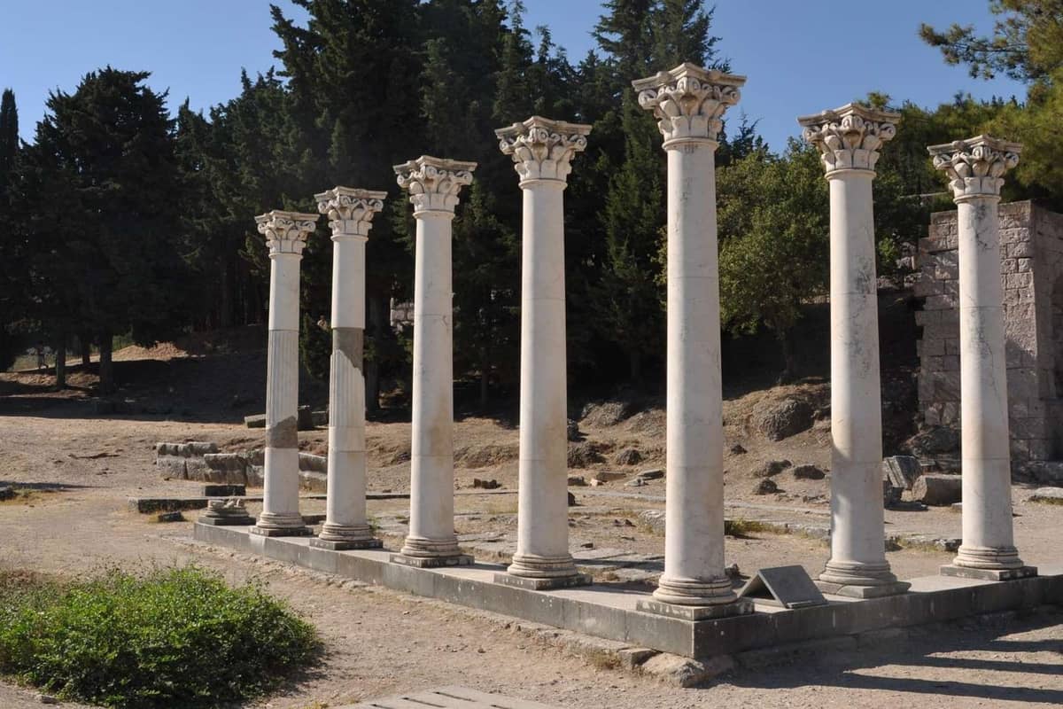
West of the altar stands the Ionic temple of Asclepius from the third century BC. The priests’ quarters lie beside it. East of the altar stands a small temple of Apollo from the second century AD. Seven restored Corinthian columns of this temple rise on kos greece today.
The third terrace is crowned by the large Doric temple of Asclepius, which dates to the early second century BC. In the middle Byzantine years, people built a church called Our Lady of the Grove in its entrance hall. A Ptolemaic decision in 260 BC recognised the right of immunity for the Great Asklepieion celebrations.
Rudolf Herzog and Iakovos Zarraftis uncovered the sanctuary of kos greece in the first years of the twentieth century. Excavations went on under Luciano Laurenzi and later Luigi Morricone in the nineteen-thirties. The finds included statues, surgical instruments and inscriptions. A snake wrapped around a staff, a symbol of medical institutions today, is modelled on the staff of Asclepius.
Which castles and ruins stand on kos greece?
Medieval castles stand on kos greece at the harbour of Kos Town, at Antimachia, at old Pyli and at Kefalos. Early Christian and ancient ruins lie close to Kefalos, on the western side. The national tourism site compares the whole island to an open-air museum.
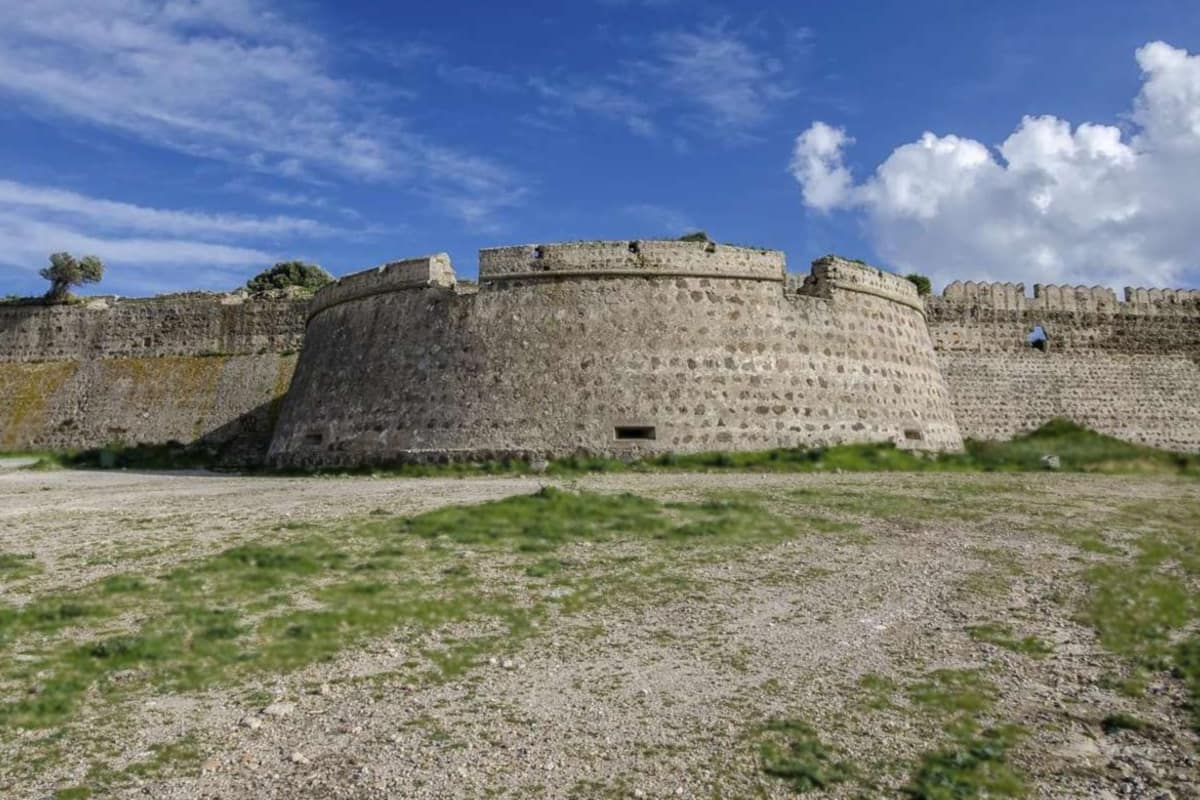
Built by the Knights Hospitaller, Neratzia stands where the harbour of Kos Town meets the sea. Building lasted from the fifteenth century into the early sixteenth. The castle has two enclosures, an inner one and an outer one. The official site links its name to the orange and lemon trees that once grew densely on kos greece.
The castle of Antimachia on kos greece stands about 24 kilometres from Kos Town. The Knights Hospitaller of Saint John built it in the Late Middle Ages. Its plan is a triangle, with a crescent-shaped bastion at the entrance. Inside lie the ruins of the old settlement and two churches, Agios Nikolaos and Agia Paraskevi.
Old Pyli is a castle-town on a hill, 300 metres above sea level. The ruins stand 3 kilometres south-east of today’s Pyli village and 15 kilometres from Kos Town. The town dates to the eleventh century. Seven towers from different periods remain. Three churches stand among the ruins: Panagia Kastriani, Agioi Asomatoi and Agios Antonios.
The castle of Kefalos on kos greece stands 350 metres from the village of Kefalos. The Knights Hospitaller of Saint John built it on the foundations of a thirteenth-century fortification. Views from the site reach Kefalos bay and the volcanic island of Nisyros. It served as a refuge for the people of Kos during the Ottoman attack.
Two early Christian basilicas of Agios Stefanos lie in Kamari bay near Kefalos on kos greece. The larger one had a rectangular atrium with granite colonnades on three sides. Mosaic floors survive in part. Luciano Laurenzi found the ruins in nineteen thirty-two. The islet of Kastri in the bay carries the chapel of Agios Nikolaos.
About 3 kilometres south of Kefalos village lie the ruins of ancient Palatia. They include a temple of Demeter from the fifth century BC, a Hellenistic theatre and a later Doric temple. The church of Panagia Palatiani stands there. An ancient town named Antimachia, capital of the districts of Aegelus and Archia, stood near the modern village.
Which beaches stand out on kos greece?
The beaches are the main draw of kos greece. Wikipedia ranks tourism first among the trades there and calls the beaches the primary attraction. The official tourism site counts dozens of easy-to-reach beaches. The shores run from pebbles near the capital to golden sand and dark sand.
Beaches near the capital of kos greece come in two kinds. The official tourism site calls the town beach narrow and urban. It places sandy Lambi 4 kilometres to the north and pebbled Psalidi 3 kilometres to the south. The page says well-equipped beaches lie close by, and Psalidi offers every kind of water sport.
Tigaki and Marmari lie close together on kos greece. The Tigaki page of Wikipedia calls Tigaki Beach and Lambi Beach popular sandy beaches. It puts the sea only about 150 metres from the centre of the village. The official site names the trails around Marmari and Tigaki beach for seaside horse rides.
Mastichari gives kos greece a sandy main beach on the north-western side. Wikivoyage says beach furniture covers the part nearest the village in summer. It ends near a windsurfing centre, and the beach beyond stays open. Only the fishing boats of the local harbour use the water, with no motorised power boats.
Kefalos Bay, below the westernmost town, holds more named beaches. Wikivoyage lists Camel, Polemi and Psilos Gremos among them. Two windsurfing schools at the bay teach all levels. The official site adds that the centres at Kefalos, Mastichari, Marmari and Tigaki fill with wind and kite surfers. It links this to their high wind probability.
Agios Stefanos, near Kefalos, is a sandy beach on kos greece, as two travel pages describe it. Both pages say a small island lies just off the shore, within reach of swimmers. A third page, Wikivoyage, names three more shores at remote Cape Krikelos: Skinos, Theologos and Moscholiou.
Quiet beaches also belong to kos greece. For peace, Wikivoyage names Lakkos, with cedars and dunes, Agios Fokas, with dark sand, and Thermes. Windy shores belong to the island too. The same page rates the north-west, around Mastichari and the Kohilari beach, as good for kiteboarding.
Which villages and mountains show the quiet side of kos greece?
The quiet side of kos greece is made of small villages, forests, wetlands and a marked mountain trail. Among the smaller villages, Wikipedia names Zia, Lagoudi and Asfendiou. The official tourism site adds hiking trails open to healthy travellers of moderate fitness.
The hike up Mount Dikaios on kos greece starts in Zia, at the spring. The official site says the signs are clearest from there. It calls the trail well marked, with dozens of signs, which makes it hard to get lost. The ancients knew the mountain as Oromedon, Orion or Dikeon.
A large cross and a small chapel dedicated to Christ stand on the summit. Clear skies bring Pserimos, Yali, Nisyros and Kardamena into sight from the top. Dozens of believers climb every year on the eve of the chapel’s celebration, which falls on the sixth of August. The bolder ones stay overnight.
A second trail on kos greece leads to the ruins of Palio Pyli. The official site presents it as one of two popular hiking trails. The route runs completely off road, into the forest. The ruined settlement was medieval, fortified and Byzantine. Its people left in the early nineteenth century, after an epidemic.
Two forests invite a stroll on the island. Plaka forest, in Antimachia, is home to peacocks and cats that live together in peace, the official site says. Tsoukalaria is a suburban forest named after its church of Panagia Tsoukalaria. The same page calls it a place to rest and recover.
Two protected bird reserves sit on the quiet side of kos greece: the Psalidi wetlands and the Tigaki salt lake. The wetlands lie 4 kilometres south-east of Kos Town. After the first rain of winter, flamingos, ruddy shelducks and long-legged buzzards can be seen there. At Tigaki, Wikipedia says, parts of the old salt works still stand.
Windmills stand over two villages of kos greece. Wikipedia notes that the windmill of Papavasilis dominates the stone height of Kefalos. The official site shows a traditional windmill at Antimachia. It adds that the island houses butterflies and reptiles, and that Bonelli’s eagle breeds on Mount Dikaios.
How do travellers reach and move around kos greece?
Travellers reach kos greece by air or by sea. The island’s airport, named for Hippocrates, stands by Antimachia village and mainly serves charter flights. The main harbour, Mandraki, stands in the city centre and offers daily links with Piraeus and other Greek ports.
The airport of kos greece peaks in summer, as Wikipedia states. Kos Town lies about 23.5 kilometres away, and the official site gives the road journey as 30 to 35 minutes. The airport opened in the nineteen-sixties. A lengthening in the nineteen-seventies gave the runway its 2,400 metres, and a new terminal followed in the early nineteen-eighties.
Flights from Athens to kos greece run up to three times a day, the official site states. They last about 35 minutes. From late spring to October, direct flights join the island daily with a number of European countries. In autumn and winter, Athens flights drop to up to two a day.
Three ground links serve the airport of kos greece. Wikipedia lists a public bus to four places: Kefalos, Kardamena, Mastichari and Kos Town. It adds a metered taxi service outside the terminal at all hours. By taxi, the official site gives about half an hour to Kos marina. Drivers use the provincial road between Kos and Kefalos.
Sea links tie kos greece to its neighbours. The official site lists daily catamaran links from Mandraki to Rhodes, Symi, Leros, Patmos and Leipsoi. Sailings are more frequent in spring and summer than in autumn and winter. Wikipedia adds that Mastichari has a port with boats regularly departing to Kalymnos.
Two more crossings link the island with its neighbours. Wikivoyage names Kardamena as the departure point for the daily high-season ferries to Nisyros. A small boat from Bodrum in Turkey takes 25 minutes and carries foot passengers only. Yachts of 8 to 80 metres berth at Kos marina.
Roads on kos greece are mainly asphalted and in good condition, says Wikivoyage. Public buses start from the central stop in Kos Town. They run to Tigaki, Marmari, Kefalos, Mastichari, Kardamena, Antimachia and Pyli. Taxis start from Akti Kountouriotou. Rental offices across the island let travellers take a buggy, a bicycle, a motorbike or a car.
What else do travellers ask about kos greece?
Which foods and drinks belong to kos greece?
The official tourism site of kos greece names a wine cheese, a tomato sweet and local honey. The white cheese comes from the milk of sheep or goats. Makers dye it and leave it in wine lees for at least one month. The page calls the texture soft and almost buttery.
The tomato sweet is a spoon sweet made from a native tomato called vergaki. The cook blends the tomatoes with sugar, cloves, cinnamon, vanilla, almonds and lemon juice. The tomatoes stay firm and sit in a syrup, like a preserve. In the days when tomato growing thrived, the page says, the island held up to eight factories.
Honey from kos greece comes as pine, heather and thyme types, and about 50 families work in the trade. For drinks, the same site names organic wine from island wineries and cinnamon served cool in a glass.
When are the warm and quiet months on kos greece?
The warm months of kos greece fill the long summer. The official tourism site describes hot, sunny summers and says temperatures reach 35 degrees Celsius in July and August. Wikipedia’s climate table records no rain in those two months. It names August the hottest, with a mean daily high of 31 degrees.
The cool winter months run from December to February. The site calls the winters mild and wet, with temperatures dropping to about 10 degrees Celsius. Wikipedia’s table makes January the wettest month. The site rates early autumn a great time, as temperatures stay mild.
The island still has winter activities, such as mountain biking, hiking and bird watching. The site says spring suits the forests and mountains, while autumn and winter bring the salt lakes to life. In summer the official wind-sport page names the seasonal meltemia and calls August the windiest month.
Which islands lie near kos greece?
Kalymnos lies close to kos greece. Its highest point reaches 700 metres, and Wikipedia puts its area at 109 square kilometres. The page calls it a popular climbing location, with routes numbering above 4,600. Pothia is the capital, and the official tourism site lists high-speed catamarans from Kos.
Two islands stand about 3.5 kilometres away from Tigaki on kos greece: Pserimos, and Platy, which has no residents. Nisyros lies to the south, and the official site says a visitor there can walk on an actual volcanic crater.
Boats from the Turkish port of Bodrum cross a stretch of the Aegean Sea 20 kilometres wide, says Wikipedia. The official site adds that Patmos has almost daily links by high-speed boats and larger ferry boats. Leipsoi has links by high-speed boats, too.
Timetables change with the season, so a traveller reads the current official page for each crossing.
Does kos greece suit cyclists?
Yes, kos greece suits cyclists, and the official sites say so. The national tourism page calls it an ideal island for cycling, with well-maintained cycle paths across much of its area. It also lists flat cycling routes along the coast. The island’s own site counts more than 10 miles of bike lanes along the coast and 6,500 bicycles for rent.
The same site grades the 10 top routes of kos greece from one to three. Grade 1 is almost flat and suits families with small children. Grade 3 needs a mountain bike and good fitness. One page says a rider can take a flat route of 60 kilometres one day. Another route runs 110 kilometres with 1,000 metres of climbing.
The Municipality of Kos now holds the Bike Friendly Destination certification. It rests on cycling routes, bicycle rental and marked bike lanes inside the municipality.
What are the thermal springs of kos greece?
The thermal springs of kos greece lie at Therma beach, also written Embros Thermae. The official site puts the beach 13 kilometres from Kos Town. Therma follows Agios Fokas along the coast and sits below a cliff at the south-eastern end of Kos. Centuries of gushing hot springs explain the Greek word for hot in its name.
The spring runs to the shore, where it meets the Aegean and forms a sea pool. The site gives the water temperature as 42 to 50 degrees Celsius. The water grows warmer closer to the source.
The water holds calcium, potassium, sodium, sulphur and magnesium, and the site mentions an intense smell of sulphur. Bubbles rise through the water, which the page links to volcanic gases pushed up from the sea bed. Public transport reaches the area, and a walk of about 10 minutes down a dusty track follows.