
Patmos Greece is a small Dodecanese island, lying between Samos and Leros off the Turkish coast, and tradition says Saint John wrote the Book of Revelation on it. Among the tours in Greece, it is the stop where a monastery, a holy cave and a white hilltop town lie close together.
Below you will find where the island lies, how its land is shaped, the port and the villages, the ancient story, the stay of Saint John, the Byzantine years, the Knights, Venetians and Ottomans, the School of Patmos, the Italian years, the UNESCO listing, the monastery, its library and treasury, Chora, the Cave of the Apocalypse, Skala, other monasteries and chapels, the beaches, quiet bays, food, festivals, the seasons, the neighbouring islands, the sea links and the ways around the island, and the answers to common questions.
What is patmos greece, and where does it lie?
Patmos greece is a small island in the Aegean Sea. Wikipedia and Wikivoyage both rank it among the northernmost Dodecanese islands. It sits off Turkey’s west coast. Christian belief ties John of Patmos to this island. In that belief, he wrote the Book of Revelation here.
In Greek, the word Dodecanese means twelve islands, as Wikipedia explains. Today the group counts fifteen larger islands, and patmos greece stands on that list beside Rhodes. Greek Wikipedia adds that the ancient Greeks counted the island in the Southern Sporades. The modern division of the country places it in the Dodecanese.
Wikipedia’s Dodecanese page gives the name a longer story. Sources from the Byzantine period first show it in the eighth century. Then it named twelve Cyclades islands around Delos. Later, twelve islands including patmos greece kept Ottoman privileges over tax and self-government. The Greek press then called that group the Dodecanese.
Greek Wikipedia fixes the place by its neighbours, not by a grid. Patmos greece lies south of Samos, south-east of Ikaria and north-west of Leros. The page gives the distance to the Turkish coast as about 25 miles. It names the cape on that coast as Gerontas, also called Poseidion.
English Wikipedia adds that the island sits further west than the islands near it. Its map point is 37 degrees 19.5 minutes north and 26 degrees 32.5 minutes east, as the page gives it. Those two figures fix the island on any chart of the Aegean.
In government terms, Wikipedia places patmos greece in the South Aegean region and the Kalymnos regional unit. The page box lists two settings: UTC+2 as standard time and UTC+3 as summer time. So the clocks of the island move forward by one hour when summer time begins.
A Greek legend, as Wikipedia retells it, gave the island its first name. The island was once called Letois, after Artemis, the goddess and huntress of deer, who was the daughter of Leto. In the legend, the island rose from the sea. Settlers from the lands around it named it in her honour.
Greek Wikipedia gives a second thread for the name of patmos greece. Ancient writers rarely name the island, and inscriptions also give it as Patnos. The old Greek word for a manger gives one reading of the name. Another reading links it to Mount Latmos in Asia Minor, where Artemis was worshipped.
How big is patmos greece, and what shapes its land?
Patmos greece covers 34.05 square kilometres, as English Wikipedia gives it, and Greek Wikipedia states 34.142. Greek Wikipedia measures the island at 12.6 kilometres long and 8 kilometres wide at the widest. Its coast runs about 70 kilometres, and its ground is rocky and barren.
The land of patmos greece forms three main parts, Greek Wikipedia explains. Two isthmuses, which are narrow strips of land, tie those parts together at the island’s centre. The same sentence adds that the ancient capital stood by them, and that ruins survive. So the island is three pieces of rock joined by thin links.
Profitis Ilias is the top of patmos greece. English Wikipedia puts it at 269 metres above sea level, and Greek Wikipedia says 270. The Greek page places the hill in the centre of the island, south of Chora. It also names two lower heights, Sklaves in the north and Praso in the south.
Greek Wikipedia calls the ground of the island rocky, volcanic and steep. English Wikipedia’s page on the Cave of the Apocalypse describes a small volcanic island in the central Aegean. Both pages therefore agree that the island is volcanic. The Greek page adds that the ground is barren, with little soil for farming.
Greek Wikipedia describes a volcanic area named Zoulouphi in the north-west corner of patmos greece. Layers of volcanic ash alternate there with lava that ran down and cooled at the sea. The page puts the walk at ninety minutes, starting at Agios Nikolaos in Kampos, the closest settlement. The other way in is by sea.
Greek Wikipedia lists the capes along the shore of patmos greece by side. Tragos, Geranos and Baloma lie on the east. Fyrro, Tsatsarla and Tsouloufi lie on the north, and the page gives Evdilos as another name for Tsouloufi. Elia, Kortesi and Genoupa lie on the south.
The same page names the bays of patmos greece. They include the harbour of Skala, Kampos, Porto Grikos and Leuki. The page also names Porto Merika, Chochlakas, Sykamia and Porto Stavros. Islets around the coast include Prasonisi, Tragonisi, Chiliomodi and Agia Thekla. Ai Giorgis, Sklava and Sklavopoula follow on the same list.
How is patmos greece divided into towns and villages?
Patmos greece has two main communities, as Wikipedia states: Chora, the capital, and Skala, the only commercial port. The same page names Grikou and Kampos as further settlements. Four kilometres separate Skala from Chora, the hill town around the Monastery of Saint John.
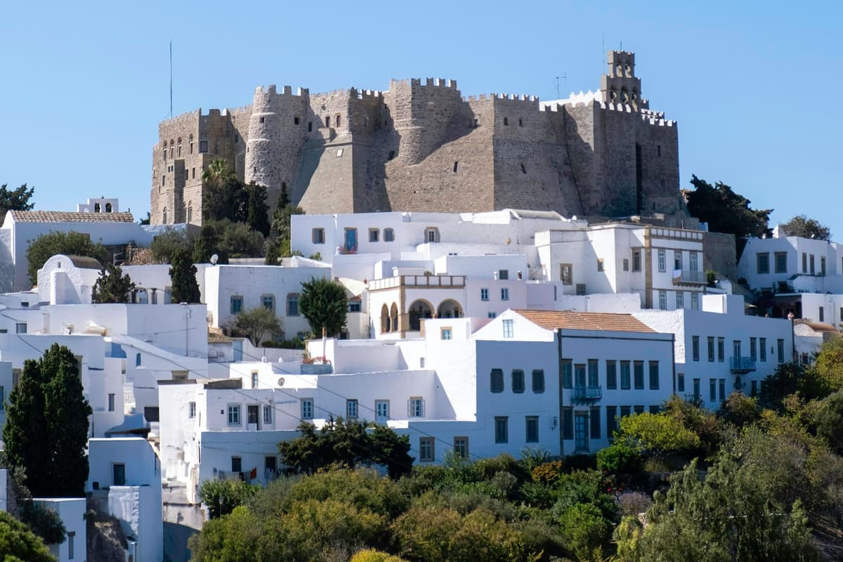
The municipality of patmos greece has its seat at Chora, says Greek Wikipedia. It says the town stands on a raised site, where the monastery dominates in the form of a large castle. Wikivoyage calls Chora a small settlement on a hill, with narrow streets, built around the fortified monastery.
Greek Wikipedia calls Skala the largest settlement of patmos greece. It also names Skala as the epineio, the harbour town of the island. Wikivoyage describes a small town built round a central square. English Wikipedia counts Skala as the sole commercial port.
Greek Wikipedia sorts the other settlements by side. Kampos and Christos lie in the north of patmos greece. Grikos and Sapsila lie in the south. Wikivoyage lists Grikos and Kampos as places in their own right, next to Chora and Skala. It adds a fifth place, Plaka, tied to the cafes and the post office.
Greek Wikipedia names five more areas of the island where houses stand: Lambi, Vagia, Leukes, Epsimia and Diakofti. The page lists them after the settlements. Spelling differs between pages. English Wikipedia writes Grikou and Wikivoyage writes Grikos. Wikivoyage adds that Kampos is spelt with a K or a C.
English Wikipedia gives patmos greece a population of 3,283 in its latest census. Greek Wikipedia states the island’s density as 96.2 per square kilometre. English Wikipedia lists 73.0 for the whole municipality, which takes in the offshore islets and covers 45.039 square kilometres.
Church life has its own map. Greek Wikipedia says patmos greece is the seat of the Patriarchal Exarchate of Patmos, which answers to the Ecumenical Patriarchate. It adds that a Greek state law declared the island a Holy Island. The exarchate also holds eight parish churches, three convents and three hermitages, as the page counts them.
Who lived on patmos greece in ancient times?
Ancient writers rarely mention patmos greece, so its first people are known only in outline. Greek Wikipedia names Thucydides and Strabo among the writers who do. It notes that inscriptions spell the island Patnos. The island stayed little known until Roman times, when it received a new role.
The first settlers came from the area of Mount Latmos in Asia Minor, Greek Wikipedia holds. People there honoured Artemis and the hunter hero Endymion, so the settlers brought her cult. Patmos and Leros shared Artemis as protector goddess. An old cult of the hunt opens the story of patmos greece.
Later mentions are short. A sailing handbook, the Stadiasmus of the Great Sea, names the island. So do Eustathius in his world description and Pliny in his Natural History. English Wikipedia notes that very little is known about the earliest inhabitants of patmos greece. Beyond such lines, the ancient sources give little more.
English Wikipedia records how the islanders saw themselves in the Classical period. The Patmians preferred to be called Dorians, descended from families of Argos, Sparta and Epidaurus. They mingled further with people of Ionian ancestry. The people of patmos greece therefore claimed roots in both Dorian and Ionian families, according to that page.
English Wikipedia reports towers and a fortification wall from the third century BC. They improved the defence of a settlement shaped like an acropolis. Greek Wikipedia places the ancient capital at a narrow neck near the middle of the island. Ruins survive there. Together these show an organised town on patmos greece before Christian times.
Artemis kept a sanctuary here. The article on Christodoulos names a site where a chapel of Saint John stood. Tradition holds that a pagan sanctuary of the goddess lay there. The cave article adds that the road from Skala to Chora leads to a temple of Artemis. Such a sanctuary marks the pagan age of patmos greece.
Roman rule gave the island a new role. Greek Wikipedia states that Patmos became a place of exile for political convicts. The cave article adds that banishment was a common punishment then. It ties the practice to the first century, when followers of Christ were banished to Patmos. The story of patmos greece now turns to Saint John.
Why is patmos greece linked to Saint John?
Patmos greece is linked to Saint John because the Book of Revelation places its author, John, on the island. Early Christian tradition identified that John with the Apostle, as English Wikipedia notes. For this reason the island is a destination for Christian pilgrimage, the same page adds.
The link starts with the book itself. Revelation opens with letters to the Seven Churches of Asia, and its author names himself simply John. In the first chapter he states that he is on the island of Patmos. For this reason he is conventionally called John of Patmos, and patmos greece enters every telling of the book.
Greek Wikipedia prints the line from the first chapter. The author states that he was on the island called Patmos for the word of God. Behind him sounded a voice like a trumpet, which asked him to record the vision in a book. The book was to go to the seven churches.
Who the author was remains a point of academic debate, as English Wikipedia notes. A tradition from Irenaeus names John the Apostle. The cave article lists John the Revelator, John the Divine and John the Theologian as his names. UNESCO adds the title Beloved Disciple. One saint thus carries more than one title on patmos greece.
Revelation is commonly dated to about the year ninety-five, and UNESCO gives the same time. That falls in the reign of Emperor Domitian, from eighty-one to ninety-six. Greek Wikipedia adds that the exile of John lasted two years. His stay on patmos greece thus belongs to the last decades of the first century.
According to tradition, John wrote the Book of Revelation in a cave on the island. UNESCO adds that he dictated it to his disciple Prochoros. The official Greek tourism site calls Patmos a significant pilgrimage site of Christendom. It presents the writing of the book in the cave as a belief.
Greek Wikipedia states that a Greek law declared Patmos a Holy Island. The island is also the seat of a Patriarchal Exarchate under the Ecumenical Patriarchate. Wikivoyage adds that its churches and communities belong to the Eastern Orthodox tradition. In law and in worship, Saint John is tied to patmos greece.
How did the Byzantine years shape patmos greece?
The Byzantine years turned patmos greece from an almost empty island into a monastic one. In ten eighty-eight, Emperor Alexios I Komnenos allowed the monk Christodoulos to found a monastery for John the Theologian. Wikipedia and UNESCO state this. The settlement of Chora then grew around its walls.
English Wikipedia records early Christian basilicas on the island after the death of John. The Grand Royal Basilica honoured Saint John and rose in the early fourth century. It stood where the monastery stands today. Raids between the seventh and the ninth century destroyed it, and church life on patmos greece barely survived.
Greek Wikipedia describes about eight centuries of obscurity after the death of John. By the tenth century, after pirate raids, Patmos was named as a little known, almost empty island. The Byzantine historian John Kameniates recorded that captives from Thessaloniki stayed six days there. Thirst afflicted them, since the place had no water.
His monastic life led Christodoulos through the Holy Land, Mount Olympus in Bithynia, Mount Latrus and Kos. He and his companions then chose uninhabited patmos greece as a place of withdrawal. English Wikipedia names its isolation as the reason, since the harbour suited regular shipping poorly. The tradition of the Revelation also influenced the choice.
At the request of Christodoulos, Emperor Alexios I Komnenos authorised a monastery in April of ten eighty-eight. UNESCO calls it part of the emperor’s policy to colonise the islands and create a base in the Aegean. He finished his monastic rule in late spring of ten ninety-one. A religious wish and an imperial plan met on patmos greece.
Disputes among the monks and incursions by Turkish forces later made Christodoulos leave. He withdrew to Euboea and died on the sixteenth of March, ten ninety-three. The monastery carried on. Greek Wikipedia states that an imperial privilege let the monks keep one tax-free ship. Dependencies followed at Stylos in Crete and on Naxos.
Houses rose around the fortified monastery. Greek Wikipedia states that lay families sought its walls as a refuge from pirate raids. Refugees from Constantinople arrived after its fall in the fifteenth century, and UNESCO names their quarter the Alloteina. The town of Chora grew gradually around the monastery, which dominated life on patmos greece.
How did Knights, Venetians and Ottomans rule patmos greece?
Ottoman rule on patmos greece lasted until nineteen twelve. A Venetian wartime base and a Russian spell came along the way. Across those years the islanders paid taxes and gifts to keep the peace. A barren island pushed them toward the sea and trade.
The Knights of Saint John belong only to the edge of this story. The Dodecanese article names fifteen twenty-two as the year the Ottomans took the islands that the Knights held. Ottoman officials ruled Rhodes and Kos straight from the centre. A second group of twelve main islands, patmos greece among them, kept wide privileges in taxes and self-government.
Greek Wikipedia explains how the islanders coped. Their land was barren, so they turned to shipping and trade, starting with small boats. They kept good relations with both the Ottomans and the Latins. They paid taxes and gifts to the Turks and the Venetians. That was how patmos greece bought its calm.
Venice used the island in war. The Greek article states that patmos greece served as a Venetian naval base. That was in the long Cretan War, which ended in sixteen sixty-nine. The English article dates the Venetian occupation from sixteen fifty-nine to sixteen sixty-nine. At the peace, Crete went to the Ottomans, and so did Patmos.
The monastery held a right of its own. The Greek article says Emperor Alexios I granted it one ship free of tax. That right and its learned monks made dependent houses possible on Naxos and at Stylos in Crete. In the seventeenth century the monastery and the island together made patmos greece a naval and trading centre.
Russian ships occupied the island in seventeen seventy, in the uprising stirred by the Orlov brothers. A census then counted 510 houses and 2,086 people. After the Treaty of Kucuk Kaynarca in seventeen seventy-four, the islanders sailed under the Russian flag. They built large ships and widened their sea trade from patmos greece.
The Greek revolt of eighteen twenty-one reached the island early. The Greek article calls patmos greece a naval centre of the uprising. A treaty signed in Constantinople on the ninth of July, eighteen thirty-two, returned the island to the Ottoman Empire. The Dodecanese article puts the final removal of the old island privileges in the years of Young Turk rule.
How did the School of Patmos shape learning on patmos greece?
Makarios Kalogeras came home to Patmos from Constantinople, where he had studied at the Great School of the Nation. In seventeen thirteen he founded the school of patmos greece. UNESCO counts it among the prominent Greek schools. The Greek article calls it the oldest working school in Greece.
The school began in the building complex of the Cave of the Apocalypse. Rooms there served as classrooms and as dormitories. Its first name meant the study house within the Apocalypse. So the first lessons on patmos greece were taught beside the cave.
The course covered classical literature and the writings of the church fathers, at secondary and higher level. Pupils came from Greek-speaking lands under Ottoman rule and from every social class, as the Greek article describes. Makarios worked to build bonds of friendship among them. The school gave the island a reach far beyond its shores.
In seventeen twenty-nine a new building rose beside the cave. A friend of Makarios, Manolakis Ypsilantis, and a guild of Constantinople funded it. Two former pupils, Kosmas and Gerasimos the Byzantine, joined as assistant teachers. A patriarchal document that year made the school of patmos greece official.
Makarios died in seventeen thirty-seven, and Gerasimos led the school for three years. In seventeen sixty-nine a patriarchal document reformed it as the Common School of the Nation. Daniel Keramevs headed it in the late eighteenth century, when it counted among the distinguished schools of its kind.
The nineteenth century was hard for schooling on patmos greece. Income stopped around the Greek revolt of eighteen twenty-one, and the old building closed in eighteen fifty-six. The school moved to a house in Chora, and its library went to the monastery. In nineteen hundred a society called Anatoli reopened it. Six years later it moved to Samos.
The Greek article names notable pupils. They include Patriarch Gregory V and the scholar Dimitrios Galanos. Emmanouil Xanthos, a founder of the Filiki Eteria, is on the list, as is Amphilochios Makris, a twentieth-century saint. The Academy of Athens gave the school its gold medal in nineteen seventy-five, a sign of what patmos greece taught.
What did the Italian years and the union with Greece change on patmos greece?
Italy held patmos greece from nineteen twelve until nineteen forty-three. A treaty of February, nineteen forty-seven, then ceded the Dodecanese to Greece. UNESCO and the English Patmos article place the union of Patmos itself in nineteen forty-eight. The pages therefore differ by a year.
Italy occupied the Dodecanese in the Italo-Turkish War of nineteen twelve, except for Kastellorizo. A treaty that year promised to return the islands to the Ottomans. Its vague wording allowed a provisional Italian rule instead. Turkey gave up its claims in nineteen twenty-three, and Italy annexed the group, patmos greece included.
Italian interest in the islands was strategic, the Italian Islands article states. Leros and Patmos served as bases for the Royal Italian Navy. The census of nineteen thirty-six counted 3,184 people in the unit formed by Patmos, Agathonisi and their islets. That unit covered 57.1 square kilometres. In that plan patmos greece served as a naval base.
Policy toward the islanders changed over time. Governor Mario Lago favoured peaceful coexistence. A later governor ruled from nineteen thirty-six to nineteen forty. Under him Italian became compulsory in school and public life, and Greek became an optional subject. Islanders did not gain full citizenship. These rules covered the whole group, patmos greece included.
The war years brought new rulers. In September nineteen forty-three, after the Italian capitulation, German, British and Italian forces fought the Dodecanese campaign. The Germans prevailed, and the Greek article says German units replaced the Italians on the island. The last German military governor of the Dodecanese surrendered to the British in late spring, nineteen forty-five.
The Treaty of Paris, signed on the tenth of February, nineteen forty-seven, ceded the islands to Greece. The English article on Patmos says the island stayed autonomous after the Germans left in nineteen forty-five. Union with the Greek state followed in nineteen forty-eight, together with the other Dodecanese islands. Both dates appear for patmos greece, so this page names both.
The union also reopened the school of patmos greece. It reopened in September, nineteen forty-seven, with 49 pupils. King Paul laid the stone for the new building in nineteen forty-eight. Today the school runs as a model ecclesiastical gymnasium and lyceum, taking pupils from Greece and abroad.
After the union, rules for Chora followed. UNESCO states that ministerial decisions protecting the settlement have applied since nineteen forty-eight. Every intervention there needs the approval of the regional antiquities office for the Dodecanese. Those rules still guard the old centre of patmos greece.
Why did UNESCO list the old centre of patmos greece?
UNESCO listed the old centre of patmos greece in nineteen ninety-nine. The property has three parts. The parts are the settlement of Chora and the walled monastery named for Saint John. The third part is the sacred cave on the road below. Three cultural criteria support the listing, and each one speaks for a different part.
UNESCO gives the property one long name that carries all three parts. The decision came at the twenty-third session of the World Heritage Committee, and the file carries the number 942. So the old centre of patmos greece is more than a town. It is a settlement, a fortress and a holy place read as one.
Criterion three concerns the town. UNESCO notes that Chora has developed continuously from the twelfth century onward, which is rare in Greece. The same text adds that ceremonies from early Christian times are still practised there unchanged. That record is one reason the old centre of patmos greece was listed.
Criterion four calls the monastery, the cave and the medieval town together an outstanding Greek Orthodox centre of pilgrimage. UNESCO names Saint John’s the only Orthodox monastery built with a supporting community from its origins. In Greece, no other fortified monastery has such a settlement. That pairing of walls and town sets patmos greece apart.
Criterion six concerns the writing. UNESCO says the monastery and the cave mark where Saint John the Theologian composed his Gospel and the Apocalypse. The summary text calls the island reputed to be that place. Pilgrimage and learning have centred on the monastery ever since. Wikipedia confirms that patmos greece remains a destination for Christian pilgrimage.
UNESCO calls the property well kept. The monastery, the cave and Chora still hold their basic form. No change to the area is allowed until the regional antiquities service of the Dodecanese approves it. That rule dates from the time the island joined the Hellenic state. The old centre is therefore guarded by law.
UNESCO lists tourism and the growth of the port at Skala as the main risks to the setting. It also notes that the island lies in an earthquake zone. Church and civil bodies work together on site care, it adds, which keeps the calm that suits sacred places. That care protects the island as a whole.
What does the Monastery of Saint John show on patmos greece?
The Monastery of Saint John shows patmos greece as a fortress and a church in one. Its outer form is a polygonal castle with towers and battlements, as UNESCO describes it. Inside stand chapels, wall paintings and a working monastic community. The town of Chora grew around its walls.
According to Wikivoyage, the walls look like a fortress and rule the skyline of patmos greece. The Greek Wikipedia article adds battlements and buttresses to those walls. It also notes cisterns inside the enclosure. English Wikipedia ties the strong outer walls to the danger of piracy and of the Seljuk Turks.
A fortified gate leads in from the cobbled path through Chora, as two pilgrimage pages describe it. Beyond it lie linked courtyards, white buildings and arched passages. The courtyards grew over centuries, one of those pages notes. UNESCO adds that the monastery of patmos greece has changed with political and economic life for over 900 years.
UNESCO dates the oldest parts of the monastery to the eleventh century. They are the Katholikon, which is the main church, the Chapel of Panagia and the refectory. Wikipedia describes the Katholikon as a domed church on a cross-in-square plan, the standard Byzantine shape. These early buildings anchor the monastery of patmos greece.
The floor of the Katholikon is worked in marble with the opus sectile technique, Wikipedia notes. Its walls hold wall paintings and frescoes from the Middle Ages. Wikivoyage lists richly decorated chapels, frescoes and a library among the sights inside. The monastery therefore shows art on its floors and walls alike.
On the north and the west, UNESCO places white-walled monks’ cells. The outer porch of the main church makes the east side. The south side is the Tzafara, a two-storey arcade of dressed stone from the late seventeenth century. Together they close the square on every side, like a fortress on patmos greece.
A chapel for the founder, Christodoulos, holds his relics, as two pilgrimage pages state. Wikipedia counts Saint Thomas the Apostle’s skull among the relics. UNESCO describes an active monastic community, so the monastery of patmos greece is a place of worship. For entry rules and opening times, read the monastery’s own website.
What do the library and the treasury hold on patmos greece?
The library and the treasury hold the books and the objects of patmos greece. The library shelves hold 330 manuscripts at the least, Wikipedia reports, and 267 of those are on parchment. The treasury shows icons, vestments and church silver. UNESCO calls the collection of manuscripts, icons and liturgical objects remarkable.
The pages give different counts, so each figure here stays with its page. Wikipedia counts 82 New Testament manuscripts among the 330 in the library. Two pilgrimage pages put the whole library above 1,000 manuscripts. The size of the library of patmos greece depends on the page that counts it.
A local island page says the library of patmos greece holds the records of the monastery and the whole island. Among them is the golden bull of the emperor Alexios I, which gave Patmos to Christodoulos. Wikipedia adds that Ottoman imperial documents kept in the library certify the monastery’s trade privileges.
One book stands out: Codex 67, known as the Purple Codex. Wikipedia dates the codex to the sixth century. Its silver letters sit on purple-dyed vellum, with gold ink for sacred names. The collection on patmos greece holds 33 of its leaves, with passages from the Gospel of Mark. The National Library of Russia holds 182 leaves.
The treasury is a museum in its own right. The monastery’s partner page on an arts platform calls it the Great Treasury. It shows Byzantine and post-Byzantine works in two wings. Wikivoyage also mentions a small museum inside the monastery of patmos greece. The same page adds Ottoman and Slavic collections of documents and art.
The partner page lists what the treasury of patmos greece holds. The list runs: documents, manuscripts, early printed books, icons, church silver, vestments, carved wood, furniture, jewels and votive gifts. It adds classical and early Christian antiquities. A local page and a pilgrimage page agree on icons, embroidered vestments and objects of precious metal.
The partner page also names single pieces. They include Coptic textiles, bema doors, an Islamic lantern and a triptych with the Crucifixion. A further entry is titled The Apocalypse: The Vision of John. For dress rules and opening times, read the monastery’s own website before a visit to patmos greece.
What does Chora show on patmos greece?
Chora shows patmos greece as a medieval hill town built around a fortified monastery. The Visit Greece page describes whitewashed houses, narrow cobbled lanes, churches and two-storey mansions. Chora is one of three parts of a single UNESCO listing, with the monastery above and the cave below.
French Wikipedia notes that Chora has kept the architecture of the sixteenth and seventeenth centuries. Its white houses, including neoclassical ones such as the town hall, enclose a maze of lanes. German Wikipedia finds the winding lanes of patmos greece closer in feel to the Cyclades than to the Dodecanese.
The merchant past of patmos greece survives in the houses of Chora. Ottoman times brought wealth from trade, UNESCO states, and fine merchants’ houses there reflect it. Visit Greece adds captains’ mansions with panoramic sea views. A local page dates mansions of boat-owning families, on the brow of Chora facing Skala, to the nineteenth century.
The Nikolaides mansion is an architectural example of the urban class of patmos greece. A local page dates it to the seventeenth and eighteenth centuries. The ground floor holds rainwater tanks, store rooms, a reception area and halls. A chapel of Saint Nicholas stands inside. UNESCO notes that European Union funding supported its restoration.
A second mansion in Chora opens its upper floor as a museum. A local page states that the Simandiri mansion, built in the seventeenth century, is still a private home. On display are period furniture, kitchen tools and decorative items, with Russian icons of the fourteenth and fifteenth centuries.
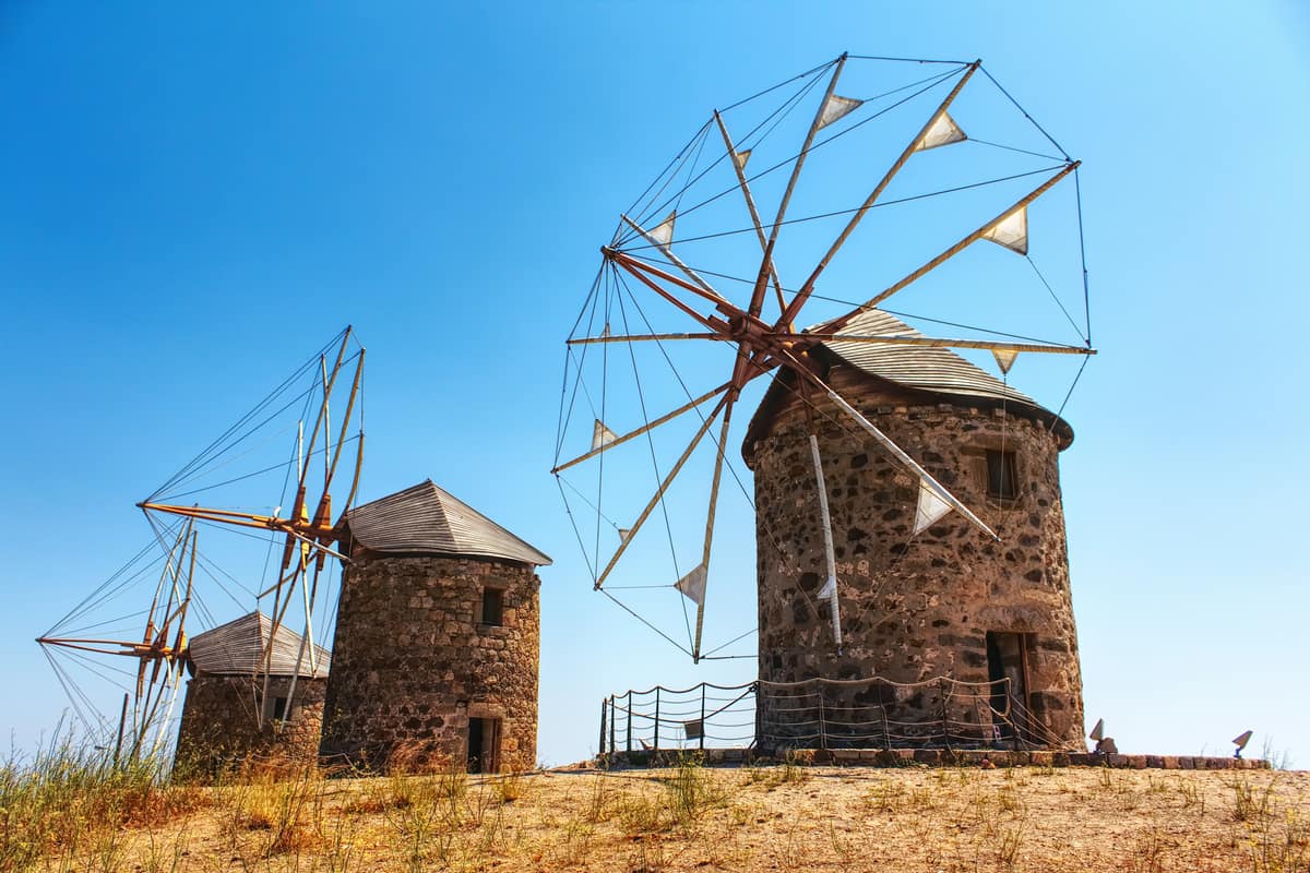
Three monastery windmills stand on a hill in Chora on patmos greece. Two date from the sixteenth century and the third from the nineteenth. Flour production ended in the nineteen fifties, and the mills then fell into disrepair. The jury of the European Heritage Awards called their restoration outstanding in detail and completeness.
Wikivoyage counts the outlook from almost any point in Chora among the sights of patmos greece. Behind the monastery, the page adds, a small spot looks out to sea. It calls the place very quiet and asks visitors to keep it that way. UNESCO adds that new buildings use traditional methods and materials as far as possible.
What does the Cave of the Apocalypse show on patmos greece?
The Cave of the Apocalypse stands on the hill between Skala and Chora. According to tradition, Saint John received his visions here. UNESCO lists the cave with Chora and the monastery as one World Heritage Site of patmos greece. French Wikipedia dates this tradition to the end of the eleventh century.
In the French Wikipedia account, John left the town for a quiet place and found a cave with running water. After ten days apart, a voice told him to stay ten more, promising a revelation. Prochoros then wrote down his words over two days. The Apocalypse was read to the Christian community of patmos greece.
UNESCO describes small churches, chapels and monastic cells that gathered around the cave. Together they make an architectural ensemble on patmos greece. Orthodox Times places the church of Saint Anna beside the cave, with the cave on its right. Greek Wikipedia names the cave of Saint Anne as the place where John wrote the Apocalypse.
A mosaic above the entrance names Saint John the Theologian and shows him with Prochoros. A local page counts 43 steps down into the cave of patmos greece. The same page says the southern part of the cave serves as a temple for pilgrims. Wikipedia notes portraits and sculptures of the apostle on the inner walls.
Christian tradition tells of three thin openings in the rock, a symbol of the Holy Trinity. The tradition links the tearing of the rock to the voice that was heard. Wikipedia and Orthodox Times both say visitors to patmos greece can touch the openings. French Wikipedia adds that art has shown John with Prochoros here since the fourteenth century.
Inside, one wall has a hollow where the elderly John is believed to have rested. A grip in the wall and a natural ledge for his scroll are also pointed out. A lectern of human height, used by Prochoros, is open to visitors. According to Wikipedia, these features tell the story of John’s time on patmos greece.
UNESCO adds that European Union funding supported conservation of the cave complex. A local page says that on reaching the island, Saint Christodoulos restored the cave. Orthodox Times adds that a temple of Saint John the Theologian lies within the cave itself. French Wikipedia adds that John is said to have lived in a cave, later a chapel.
What does Skala offer as the port of patmos greece?
Skala is the port town of patmos greece, set in a long bay. German Wikipedia calls the bay an ideal natural harbour. French Wikipedia names the town the administrative and economic centre of the island. Ferries and cruise ships arrive here, and the monastery looks down on the town.
A local history page says a traveller of the seventeenth century found a big, secure port here. It calls this the first evidence of Skala, which grew gradually into a settlement. The page adds that Skala began as a mooring place. French Wikipedia sees the old trading power of patmos greece in the houses of Skala and Chora.
German Wikipedia finds Venetian elements in the older buildings along the harbour front. Frequent ferries arriving and leaving give the harbour of patmos greece a busy feel, the same article says. French Wikipedia adds that the bustle around Chora hardly touches Skala. It calls Skala a small port, with old churches that are rarely visited.
German Wikipedia records that Skala housed the post office, the customs office and the military administration under Italian rule. These economic and political reasons made Skala the secular main town of patmos greece, it explains. Before that, the article adds, Skala was only the stairway to the monastery.
French Wikipedia explains that the word skala means stairs or ladder, and it also names a port. Italian Wikipedia counts four quarters in Skala. It names Netia, in the harbour town of patmos greece, as the quarter with the dock for ships from Piraeus.
French Wikipedia calls Skala a popular call for cruise ships, which stop for a short time. Passengers use that time to go up to the monastery that overlooks the town. In summer the port is sometimes crowded, and ships then anchor offshore. Shuttle boats carry their passengers to the port.
On the height of Kasteli, near the harbour of patmos greece, Italian Wikipedia notes a wall of black stone. A local page calls the remains an acropolis whose walls carry towers. It adds that the masonry is Hellenistic and stayed in use into Roman times. The same page places a temple of Apollo on Kasteli.
Which other monasteries and chapels stand on patmos greece?
Beyond the great monastery, patmos greece has two convents at Chora, according to the French Wikipedia. One is Zoodochos Pigi, the other is the Annunciation, also called Evangelismos. Both are women’s communities, and both stand in Chora, the hill town that grew around the fortified monastery.
The convent of Zoodochos Pigi is the older of the two convents on patmos greece. The French article dates its founding to the early seventeenth century. It names the founder as the monk and priest Parthenios Pankostas, an abbot of the Monastery of Saint John. The name means Source of Life and refers to the Virgin Mary.
The convent of the Annunciation, also known as Evangelismos, is younger. The French article dates its founding to nineteen thirty-seven. A photo caption on the Greek Wikipedia shows this women’s monastery with Profitis Ilias, the highest peak, behind it. The two founding dates stand more than three centuries apart on patmos greece.
The Greek Wikipedia describes a wider church district based on patmos greece. It is the Patriarchal Exarchate, which also takes in nearby islands. The list counts eight parish churches, three hermitages and six holy seats. Its three women’s monasteries are Zoodochos Pigi, Mitros Igapimenou and Agia Agion. A pilgrimage monastery called Panagia Diasozousa is listed too.
The rock of Kalikatsou rises from a bay in the south of patmos greece. The German Wikipedia puts its height at about 20 metres. Steps and hollows are cut into it all round, and a cistern on top still works. The Greek Wikipedia calls the rock a hermitage and places it at Petra beach.
A tiny chapel on patmos greece encloses a spring in the valley that runs into the bay of Grikos. The German Wikipedia places it halfway along the road between Grikos and Chora. According to tradition, the first people who called themselves Christians were baptised there. The stream from the spring flows all year, and the valley keeps its original plants.
Two small chapels survive at Skala, the port of the island. The Greek Wikipedia states that one is dedicated to John the Evangelist, the apostle linked to the island. The other honours two of his disciples, Polycarp and Prochorus. Wikivoyage adds that all the churches and communities of patmos greece follow the Eastern Orthodox tradition.
Which beaches stand out on patmos greece?
Sand and stones change with the coast on patmos greece. The German Wikipedia ties sand to the southern and eastern shores alone. In the north the beaches are made of coloured stones, and the west side is mainly steep cliff. Each paragraph below gives one plain fact for one beach.
Psili Ammos is the sandy beach in the south of patmos greece. Wikivoyage describes soft golden sand, clear shallow water, rolling dunes and little building behind the shore. The way in is by boat or on foot along a hiking path. A small seasonal taverna serves simple meals and drinks there.
Lambi lies in the north of patmos greece, and its beach is made of coloured stones. The German Wikipedia notes that the stones reach the size of a walnut. Wikivoyage reports that visitors took a large share in ten years. It asks travellers to leave the rest, since only a small number of the special coloured ones remain.
Agrio Livadi, as Wikivoyage spells it, lies north of Skala and faces nearby islets across the water. The page describes a laid-back mood there. The Italian Wikipedia counts the beach among the better-known ones on patmos greece. Its list also names Psili Ammos, Grikos, Petra, Le Gemelle, Livadi, Kampos, Vagia and Lambi.
Livadi Geranou is a beach on patmos greece with a view of Lipsi. A caption in the German Wikipedia shows it from the terrace of the only restaurant there. Lipsi can be seen on the horizon from that terrace. Wikivoyage describes the small beaches and coves in general: a cafe and sunbeds at one, nothing at the next.
Petra is the beach beside the rock of Kalikatsou. The English Wikipedia pairs the two names in one photo caption. The German Wikipedia places the rock in a bay of the south, shielded by a smaller island. The same article groups Petra with the nearby settlement of Grikos under one heading on patmos greece.
Getting to a beach is simple here. The German Wikipedia states that roads lead to almost every bay and landmark, and a local island information page agrees. The German article adds that a bay with only one restaurant is not rare. So the beaches stay plain and little built.
Which villages and bays show the quiet side of patmos greece?
Skala is the largest settlement of patmos greece, the Greek Wikipedia states. Other settlements are Kampos and Christos in the north, and Grikos and Sapsila in the south. Chora, the capital, stands on a height under the monastery. Together these places hold the quiet side of the island.
Grikos is the younger settlement on the south coast of patmos greece. The German Wikipedia records that it grew up in the twentieth century and looks mainly to tourism. The Greek Wikipedia lists the cove of Porto Grikos among the bays of the island. Wikivoyage also lists Grikos beside Chora, Kampos and Skala as a place of the island.
Kampos is a village and a bay in the north-east of patmos greece. The Greek Wikipedia names the bay of Kampos among the coves of the east coast. Ancient burial grounds came to light at Kampos, the Italian Wikipedia reports. It files these finds under the Hellenic era, long before the monastery rose.
Beyond the settlements, the Greek Wikipedia names areas where a fair number of homes stand. They are Lambi, Vagia, Lefkes, Epsimia and Diakofti. The same page names more coves: Porto Merika, Hochlakas, Sykamia and Porto Stavros. That string of names shows how deeply cut the coast of the island is. Lambi shares its name with the coloured-stone beach.
The volcanic area of Zoulouphi lies on the north-west side of patmos greece. The Greek Wikipedia reports that ash alternates there with lava that flowed down and froze at the sea. Access is by sea, or by a walk of ninety minutes from the nearest settlement, Agios Nikolaos of Kampos. The same page calls the landscape there very impressive.
Walkers find a network of paths on patmos greece. A local island information page gives its total length as 30 kilometres and says the paths are mapped. Wikivoyage calls the island good for walking in cooler months and stresses that it is very hilly. It warns that the high summer temperatures make the hills hard work.
The south coast of patmos greece is a protected area under the European Natura network. The German Wikipedia notes that it covers the sea off the south, rocky islets and the isle of Chilomodi. The same article adds that building permits are harder to obtain since the island became a state sanctuary. That keeps the number of guests limited.
Which foods and drinks belong to patmos greece?
The food of patmos greece rests on honey, cheese, meat, fresh fish and seafood. A Greek government farming portal lists these as the base of the island’s cooking. The goats graze on uninhabited islets nearby. The same page adds that the local cheese pie joins savoury cheeses to the sweetness of cinnamon.
Fresh fish and seafood form part of the base of the cooking of patmos greece. The farming portal says the locals prefer their fish grilled. It also calls squid stuffed with rice and raisins a dish worth trying. The same stuffing fills the local stuffed peppers. Wikivoyage lists grilled fish and stuffed peppers too.
Wikivoyage describes how fresh produce reaches the table. A fish van sells in the morning in the square of Skala and in the square of Kampos. A second van brings vegetables and fruit to those squares, with watermelons and melons singled out. The page also lists bread, pastries, yogurt, honey and olive oil among the foods of the island.
Meat on patmos greece comes especially from goats, the farming portal says. They graze on the uninhabited islets near the island. A Greek gastronomy site says kid dominates the festive table. One version is kapama, cooked with tomato and cinnamon.
The farming portal calls the cheese pie of patmos greece unique. It marries savoury cheeses with cinnamon and a dash of sugar. The Greek gastronomy site adds that the pie differs from the pies of other islands in size, shape and taste. Cheese stands beside honey, meat and fish among the basics that the portal names.
The farming portal names three sweets of patmos greece. Dumplings stuffed with walnuts and honey are the first. Almond sweets, which the island calls achladakia, are the second. Fluffy loukoumades, fried and drizzled with local honey, are the third. Wikivoyage adds sweetmeats and spoon desserts to the list of sweets.
Wikivoyage names mountain tea, which grows wild on the island, among the drinks of patmos greece. It also points to white wines that drink well cold and adds that not every wine is retsina. A local island portal describes a custom after a saint’s day service. The congregation receives Greek coffee with traditional pies and sweets, sometimes with rose water.
Which festivals and customs mark the year on patmos greece?
On patmos greece, the leading church ceremony of Holy Week is the Washing of the Disciples’ Feet on Holy Thursday. The official Greek tourism site describes it. In the square of Chora, the abbot takes the part of Christ and washes the feet of twelve monks.
A stage is built for the ceremony, the tourism site says. After the washing, the abbot steps off the stage and goes to a sacred place to pray. The site links this walk to the way Jesus followed towards the Garden of Gethsemane. The monastery keeps early Christian practice alive on patmos greece, it adds.
On the same evening the Deposition from the Cross is re-enacted in the Monastery of Saint John. The epitaphs of the island’s churches fill the narrow cobbled lanes. They meet at the central squares of Chora and of Skala. The tourism site calls the whole week deeply spiritual.
A Greek customs website dates the Washing to the building of the monastery. It began in the main church, moved to its courtyard, and from the sixteenth century took place outside the monastery. On patmos greece the rite now takes place in the Western Square of Chora, named after Emmanuel Xanthos. In good weather it moves to the Eastern Square.
On the evening of Holy Saturday the monastery opens its gates for the Resurrection service. On Easter Sunday at three in the afternoon, the Liturgy of Love follows there. The Gospel is read in seven languages, and the abbot gives red eggs to all who attend. The forty-day fast ends with traditional Easter dishes on patmos greece.
Saint John has two feast days on patmos greece, a local island portal says. One falls in late spring and the other on the twenty-sixth of September. A news report on the September feast puts the focus at the monastery. Vespers, the vigil and the liturgy took place in the main church, and the Artoklasia closed the service.
Summer feasts on patmos greece centre on small chapels. On the eve of Saint Panteleimon, boats leave Skala for the islet of Chiliomodi, where the evening service is held. The feast of Panagia Geranou follows the hymns on the eve of the fifteenth of August, at a hilltop chapel. Both feasts bring food, drink, music and dancing.
Autumn adds the feast of Saint Thekla on the twenty-fourth of September. Her chapel stands on a small islet opposite Agriolivadi beach, and boats bring visitors for the evening hymns. Wikivoyage places a festival of religious music in September at the open-air theatre by the cave, with concerts at night.
When do travellers visit patmos greece, and what do they pack?
The sea at patmos greece is warm enough to swim in from July to September, a climate page says. The same page names June to mid-September as the beach season. For excursions and hikes, it points to April and late spring, and to September and October.
The climate of patmos greece is Mediterranean, with mild, rainy winters and warm, sunny summers, the climate page says. Rain is concentrated between October and April and adds up to almost seven hundred millimetres a year. In summer it almost never rains, so the landscape is semi-arid.
The meltemi, a north-west wind, blows in summer and is weaker on patmos greece than on the central Aegean islands. The climate page calls the sunshine great in summer, when clear skies prevail. It adds that hot spells lasting days bring highs of thirty-three to thirty-six degrees Celsius.
Wikipedia notes that the economy of patmos greece relies on tourism in the summer months, when Christian pilgrims visit frequently. Autumn runs from mid-September to November, warm at first, with more rain as it goes. Winter is mild, with daytime highs near thirteen or fourteen degrees Celsius, the climate page adds.
Walking on patmos greece suits the cooler months, Wikivoyage notes, and the island is very hilly. As the cave article describes it, Chora is highly compact, with very narrow streets and walkways on sloping ground. Choose soles that grip, for the hill town and for the footpaths.
Wikipedia describes the monastery and the cave as Greek Orthodox places of worship. The Greece page of Wikivoyage names a common church rule. Women cover their shoulders, and every visitor covers the knees. So a thin shawl or an extra shirt goes into the bag for patmos greece.
Sun cover comes next. For the summer heat, the Greece page of Wikivoyage lists a light hat, sun glasses and water. A sweatshirt helps on cool evenings, which come mainly in June, the climate page says. So the pack for patmos greece holds sun cover for the day and a light layer for the night.
Which neighbouring islands lie close to patmos greece?
Wikipedia fixes Arkoi by compass points from three islands. Patmos lies to its west, Lipsi to its south and Agathonisi to its north-east. That chain maps three neighbours of patmos greece. Greek Wikipedia adds that Leros lies to the south-east and Samos to the north. The Dodecanese article borders the whole island group with Turkey in the east.
Lipsi is a ferry neighbour of patmos greece. Wikipedia describes it as well served by ferries passing between Patmos and Leros, on the main route from Piraeus. The same article gives Lipsi 15.95 square kilometres. It counts about 37 islands and islets in the wider group around Lipsi and Arkoi.
Arkoi belongs to the municipality of patmos greece and covers 6.7 square kilometres, as Wikipedia gives it. The article states that the island has no real capital. Its people live close to the main harbour or scattered over the higher ground. A ferry that links Samos, Patmos and Lipsi calls there.
Marathi is the closest inhabited island to Arkoi, and the Arkoi article adds that occasional small ferries serve it. The Lipsi article names Leipsoi, Arkoi and Marathos as the only inhabited islands of its group. Greek Wikipedia lists Marathi among the islands under the municipality of patmos greece.
Agathonisi lies at the northernmost point of the Dodecanese, as Wikipedia states. Its two villages stand inland, Megalo Chorio and Mikro Chorio, while Agios Georgios forms the only harbour. The island covers 13.5 square kilometres and rises to 209 metres. It depended on patmos greece when Italy occupied the island, the article notes.
Leros lies south-east of the island, as Greek Wikipedia sets the pair. Wikipedia lists Patmos, Lipsi and Kalymnos as the nearby islands of Leros and gives Leros 74.17 square kilometres. Wikipedia counts the coastline of Leros at 71 kilometres. Greek Wikipedia groups Leros, Lipsi, Agathonisi and Astypalaia with Patmos in the Kalymnos regional unit.
Samos lies north of patmos greece. Wikipedia lists Pythagoreio and Karlovassi on Samos among the ports that ferries link with Patmos. The Agathonisi article records a naval engagement of 440 BC, in which Pericles defeated the Samians near that island. Wikivoyage says ferries from Piraeus and the Cyclades generally stop at both Vathi and Karlovassi on Samos.
How do travellers reach patmos greece?
Travellers reach patmos greece by sea. Wikipedia lists regular ferry services that join Patmos to Piraeus, the port of Athens. It also lists Samos, Syros, Mykonos, Paros, Naxos, Leros, Lipsi, Symi and Rhodes. Wikivoyage states that every ferry and hydrofoil lands at Skala, the only commercial port of the island.
The national tourism site of Greece gives the sea trip from Piraeus to patmos greece as 7 to 12 hours. That range is the figure the site states. Its access list names the sea route and no flight. Timetables differ, so a traveller checks the sailing of the day. The hours give the scale of the plan.
Wikivoyage sorts the sea routes by the airport of arrival. A traveller who flies into Athens takes a boat from Piraeus. One who flies into Samos takes a boat from that island. The page names this link for the northern Dodecanese too. Boats from Rhodes and Kos join the Rhodes to Piraeus route to patmos greece.
Skala also holds a marina. Wikivoyage describes a new marina for yachts in the port area of patmos greece. Wikipedia notes that no other commercial port exists on the island. Every route in this section therefore ends in one harbour town. Wikivoyage adds a central square to the picture of Skala.
The airports named by the pages lie on other islands. Leros has one at Partheni. Wikipedia says its runway of 1,012 metres suits only small aircraft of 50 seats. Wikivoyage adds that it connects Leros daily with Athens. A ferry then links Leros with patmos greece, as the Leros page lists.
Samos has an airport within 5 kilometres of Pythagorio, as Wikipedia states, with a runway of 2,100 metres. Wikivoyage lists daily flights there from Athens that take 55 minutes. It adds that hydrofoils to the Dodecanese islands leave regularly from Vathi and Pythagorion. The airport can be walked from Pythagorion town.
Kos Airport lies 24 kilometres from Kos town, close to Antimachia village. Wikipedia gives its runway as 2,400 metres and names the Kos to Kefalos road as the way in. Wikivoyage names four departure ports for the daily ferries to Kos: Piraeus, Rhodes, Patmos and Leros. It places Kos on the route that carries boats on to patmos greece.
How do travellers move around patmos greece?
The bus is the plain answer on patmos greece. Wikivoyage lists a service of about one bus an hour that links the harbour of Skala with Chora. Other services run from Skala to Kampos, and from Skala and Chora to Grikos. Hire cars, bikes, mopeds and taxis are also available for hire in Skala.
Three bus services are named, and Wikivoyage says the bus times are posted at the stop. It advises asking whether the bus runs today, yet it calls the service punctual. Photocopies of the timetable are left for visitors to take. A traveller on patmos greece can therefore plan a day around the stops.
Wikivoyage places the hire shops in Skala, so the choice of wheels is made at the harbour. Cars, bikes and mopeds are available there, together with taxis. The same page also lists Plaka, the district with the cafes and the post office. A traveller to patmos greece finds the transport in one place.
Wikivoyage suggests walking in the cooler months, or in summer for those who can cope with the high temperatures. The page repeats that the land is very hilly. A walker on patmos greece plans the hours of the day with care.
Wikivoyage recommends the hike down from Chora to Skala. The walker takes the footpaths and visits the Cave of the Apocalypse halfway. The cave article sets the grotto midway up the mountain, on a steep road from Skala to Chora. Both pages therefore put the cave in the middle of the route on patmos greece.
Inside Chora the lanes are narrow. Wikipedia describes a compact town of very narrow streets and walkways, with the monastery at its centre. The houses follow the sloping streets, which gives the town an uneven look. The cave article adds that a single road, running across the whole island of patmos greece, leads to the town.
Boats serve the coast. Wikivoyage says small boats do day trips to Psili Ammos and to the nearby islands for swimming and lunch. Its beach entry calls Psili Ammos accessible by boat or by a hike. A traveller to patmos greece picks the boat or the footpath for that beach.
What else do travellers ask about patmos greece?
Who helps in an emergency on patmos greece?
Per Wikipedia, patmos greece has a medical centre staffed by doctors. Residents who need hospital care beyond first aid are flown out by helicopter in emergencies. When the weather allows, they go by ferry instead.
Wikivoyage’s page on Greece backs this up. It says helicopter ambulances link the islands to hospitals. Patients in urgent need go to the closest island or city with a big hospital.
The municipal brochure lists separate telephone lines for the health centre, the police department and the port authority. Wikivoyage’s page on Greece gives the national numbers. They are 112 for emergencies, 100 for the police, 166 for medical emergencies and 199 for the fire department. A traveller to patmos greece can note them before the trip.
For a simple, common illness, that page names a visit to the pharmacist as the answer. Sunday closing is common, and a sign on the door points to the nearest open pharmacy.
Is patmos greece a quiet island, or does it have nightlife?
The municipal brochure answers both ways. It calls the style of patmos greece devout and cosmopolitan at once. It adds that the island is decidedly not a noisy one. It draws people who look for peace, tradition and spirituality.
The same brochure lists cultural festivals, religious events, nightlife and food among the draws of the island. For the religious events, it names Holy Week in particular.
Skala, the port, has cafes, restaurants and bars, a market with traditional products and a seaside promenade, the brochure says. Of Chora, it says the evening mood blends serenity, spirituality and elegance. Those lines show two sides of patmos greece.
For calm, the brochure names Grikos, a tranquil seaside place about four and a half kilometres from Skala. Tavernas line the shore there, and tamarisk trees give shade. For family time, it names Kampos, which it calls cosmopolitan, and well-organised Agriolivado.
Which people and sister towns link patmos greece to the wider world?
The list of notable people on the Wikipedia page for patmos greece spans church, art and writing. It names the Patriarchs Jeremias III and Neophytus VI of Constantinople. It also names the English artist Teddy Millington-Drake and the American poet Robert Lax.
Robert Lax settled on patmos greece late in his life, his own Wikipedia article states. By nineteen sixty-two he had reached the Greek islands, first on Kalymnos. He then moved to Patmos for his last years. He sought solitude yet welcomed visitors to his home.
In the year two thousand he returned to the United States by ship, because he did not travel by air. Lax’s page adds that a film about him was made in his final years on the island.
The Wikipedia page lists two sister towns for patmos greece: Grottaferrata in Italy and Glastonbury in the United Kingdom. The Glastonbury article confirms the twinning.
Where does a traveller find official information on patmos greece?
The municipality runs a site with a tourism section for patmos greece. Its menu lists how to come, where to stay, sights, getting around, activities, dining and a municipal tourist information office. The same site also has pages on history, culture, tradition, food and nature, and on Easter on Patmos.
The visitor brochure on that site speaks to travellers bound for what it calls the sacred island of the Aegean. It comes in seven languages: Greek, English, Spanish, French, Turkish, German and Italian.
It holds a welcome note and a short portrait of each main settlement. A page on beaches and nature and a list of telephone lines follow. One line is for the tourist office.
The national tourism site has its own page on patmos greece. It lists Sacred Island, Noble Chora and Mystical Atmosphere as highlights. The monastery’s own site, in Greek, posts notices and the service programmes for Easter.
What dress and conduct do the monastery and the cave of patmos greece ask of visitors?
The municipal brochure sets one dress rule for holy churches and monasteries on patmos greece. It asks for modest clothing, out of respect for the place. No page read for this plan names other items, so this page names none.
Pilgrims arrive by the coachload at the cave, says Wikivoyage, where St. John is said to have written. It also points to a small, peaceful spot behind the monastery with a view over the water. It asks visitors to leave that spot quiet. The brochure says the monastery has kept an unbroken spiritual life.
No official page read for this plan prints opening hours, so this page gives none. The brochure lists one telephone line for the monastery and a separate one for the cave. The monastery’s own information page, in Greek, has a heading for the visiting hours of both. It also prints the Holy Week timetable.