
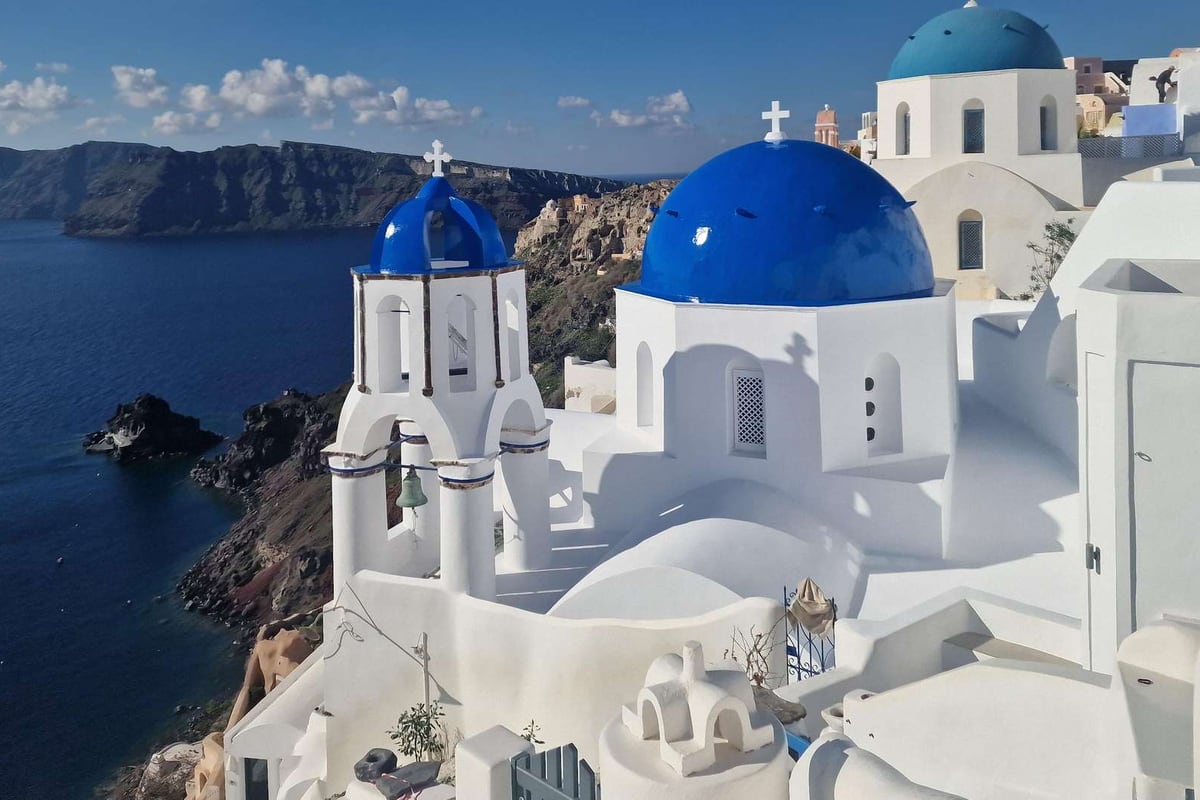
Santorini island is the southernmost island of the Cyclades, the curved rim of a volcano that sank into the Aegean Sea and left a flooded caldera with white towns along its cliffs. Travellers reach it by plane or by ferry as one stop among the tours in Greece that cross the Cyclades.
Below, the page runs from the meaning and place of the island to its size and land, the towns and villages, the volcano and the Minoan eruption, the caldera, ancient Akrotiri and Thera, the Roman to Ottoman years and the union with Greece, the earthquake, Fira, Oia and the other villages, the beaches, the volcanic islets, the museums, wines, foods and crafts, the seasons, the ferry, air and road links, the neighbouring islands, and the questions travellers ask.
What is santorini island, and where does it lie?
Santorini island marks the southern end of the Cyclades, an Aegean chain of islands. On the map of Wikipedia it lies in the south of that sea. The Greek mainland lies across about 200 kilometres of sea to the northwest. A volcanic caldera formed the small, ring-shaped archipelago around it, and this main island is the largest part.
The name covers a group and a single island. By Wikivoyage’s count, the archipelago holds five volcanic islands. Thira is the biggest by far and has 15,500 people, as that page states. The same page admits that people confusingly call Thira Santorini itself. Here, santorini island means that main island.
The group around it is small. Wikipedia counts two inhabited islands and five uninhabited ones in the municipality. Two Kameni islands rise in the middle of the flooded basin, and tiny Aspronisi lies on its outer ring. Administratively, santorini island falls under the Thira regional unit, which holds five island municipalities.
Neighbours help to place the island on the map. In the Greek Wikipedia, Ios is the island to the north, and Anafi is the one to the east. Wikivoyage agrees that the island sits between the two. So the chain of the Cyclades ends here, in the south of the Aegean.
Three names refer to santorini island: Santorini, Thira and Thera. Wikipedia lists Thira or Thera as official. Theras, a Spartan leader who settled the island, gave Thera its name, says the page. Official use of Thera resumed in the nineteenth century, for the island itself and for its chief town. Santorini remains the popular one.
The name of santorini island comes from Saint Irene. Both Wikipedia and Wikivoyage trace it to an old church of that saint in Perissa village. The first mention comes from the geographer al-Idrisi, who wrote Santurin in the twelfth century. Wikipedia ties the form to Venetian influence.
The Greek Wikipedia tells how the name spread. Frankish crusaders stopped for supplies near the church of Saint Irene, in today’s Perissa area, and called it Santa Irina. Foreign maps kept that form, and Greeks shortened it. So the everyday name of santorini island began as a stop for supplies, says that page.
Santorini island carried other names before Thera. Wikipedia says ancient writers called it Kalliste. It adds a modern tradition that names it Strongyle, “the circular one”. The Greek page says the island was round, with that name, before the prehistoric eruption. It also lists the Ottoman name Dermetzik, “small mill”, probably from the small windmills seen from afar.
Wikivoyage sums up the draw of santorini island in one line. It names white clifftop villages with sunset views and the ruins of Thera and Akrotiri. It adds local wines, artists and craftsmen, an active volcano and pebble beaches in strong colours. The next sections of this page take these in turn.
How big is santorini island, and what shapes its land?
Santorini island covers 73 square kilometres by Wikipedia’s count, and 76.19 by the Greek page. The land forms a half-circle, closer to a horseshoe than a ring. Cliffs drop to the caldera on the inner side, and gentle slopes reach the sea on the outer side.
The pages differ on the exact size of the island. Wikipedia and Wikivoyage both give 73 square kilometres. The page on the caldera gives 75.8, and the Greek page gives 76.19. The gap is about three square kilometres, so read each number as that page’s own measure.
The municipality adds more land than the main island holds. Its total is 90 square kilometres, says Wikipedia. Therasia is the second largest inhabited island, and the caldera page gives it 9.3 square kilometres. The rest of the group is tiny next to santorini island.
The Greek page explains the shape. The half-circle comes from eruptions that changed the first round form. The side that faces the volcano is rocky and steep, while the rest of the ground is smooth. Wikipedia’s page on Fira also calls Thera a semi-circular island. Every map of the island shows this open ring.
Wikivoyage calls the inner walls of santorini island steep and mostly impassable. Villages still line the ridge above them, it adds. Wikipedia says the cliff shows bands of hardened lava, laid down one layer after another. A traveller who walks the rim sees the same cut face of rock from above.
Wikipedia calls the outer face gentle. The ground falls away slowly towards the outer coastline, and the beaches there are smooth and shallow. The Greek page measures the coast of santorini island at about 36 nautical miles, with six bays. It names Ammoudi, Armeni, Mouzaki, the bays of Fira and Athinios, and Balos.
The highest point lies in the south-east. The Greek page names Profitis Ilias at 567 metres, with an eighteenth-century monastery of the same name. The mountain is limestone and white marble, the oldest rock on the island. Mesa Vouno, linked by the saddle of Sellada, reaches 366 metres on santorini island.
Water is scarce on the land. The Greek page says the island has no lakes, rivers or gorges. It gives the yearly rain as about 280 millimetres. Wikipedia names a single spring, Zoodochos Pigi, and notes the underground cisterns that kept rainwater. It adds that the soil is largely volcanic ash.
How is santorini island divided into towns and villages?
The capital of santorini island is Fira, and one municipality, Thira, governs the whole group. Wikipedia lists seventeen towns and villages, from Akrotiri to Vourvoulos. The census of twenty twenty-one counted 15,480 residents, says the page. Wikivoyage places almost all visitor services on the main island, Thira.
Santorini island forms the core of one municipality, Thira. According to Wikipedia, every settlement on the main island and on Therasia belongs to it. The local government reform of twenty eleven merged two older municipalities, Oia and Thera, into one. The infobox names Fira as its seat, and twelve more local subdivisions lie on the main island.
Wikipedia’s list for santorini island holds seventeen names. The first nine are Akrotiri, Ammoudi, Athinios, Emporio, Finikia, Fira, Firostefani, Imerovigli and Kamari. The other eight are Karterados, Messaria, Monolithos, Oia, Perissa, Pyrgos Kallistis, Vothonas and Vourvoulos. The governance section adds Megalochori and Exo Gonia.
Wikipedia calls Fira the modern capital and the largest town. The Fira page adds whitewashed houses on the caldera cliff, at the western side of the half-ring. Its name is another way to say Thira, the old name of santorini island itself. The infobox gives the Fira community 1,516 residents for the census of twenty twenty-one.
Wikivoyage says Fira runs on into the quieter village of Firostefani. Karterados, an inland suburb south of Fira, has no views. Wikipedia places Imerovigli north of the capital, on the very rim of the caldera. Oia lies 11 kilometres from Fira, in the far north-west of santorini island, with 1,087 residents in its municipal unit.
Pyrgos Kallistis, a village of santorini island, has 1,078 residents. It lies about 7 kilometres from Fira, built on a hill, as Wikipedia states. Wikivoyage calls Vothonas a small village in a ravine, with buildings cut from the ravine itself. Old white Cycladic churches mark Megalochori, which that page calls a traditional village.
Wikivoyage ranks Emporio second among the towns of santorini island. Narrow cobblestone streets run through it, and a Venetian castle sits on a hilltop. The village of Akrotiri gave its name to the Bronze Age site, per Wikipedia. Vourvoulos is an inland town, and Finikia a well-preserved traditional village.
Kamari, on the coast of santorini island, is a cozy town with a black sand beach, says Wikivoyage. The ruins of Ancient Thera top the hill above it. Vlychada, a fishing village, sits on the southern shore beside a large marina. Kamari joins Episkopi Gonias, also called Mesa Gonia, in a single community of 1,252 residents, says Wikipedia.
How was the volcano of santorini island formed?
The volcano of santorini island formed through repeated cycles, as the Santorini article explains. A shield volcano grew from layers of lava, then its centre collapsed into a caldera, and the cycle began again. The story below runs from the old rock underneath to the youngest cone.
Under the volcano lies an older island. The Santorini article describes a small non-volcanic base about 9 by 6 kilometres across, made of metamorphosed limestone and schist. The Cyclades were folded in the Alpine mountain-building around 60 million years ago. Santorini island rests on that base, and the volcano was built upon it.
Oregon State University’s volcano page calls the volcano of santorini island a complex of overlapping shield volcanoes. A shield volcano is a broad mound of runny lava. Basalt and andesite flows built these mounds. The old base is blueschist, the Santorini article says, and it marks the southernmost end of the Cycladic blueschist belt.
Plate movement drives the whole system. The African plate sinks below the Aegean region at the Hellenic subduction zone. The caldera article gives the pace as up to 5 centimetres a year. The subduction builds the Hellenic arc, a chain of volcanic centres that includes Santorini island, Methana, Milos and Kos.
The Santorini article traces the oldest eruptions to the Akrotiri peninsula. This first phase started 650,000 years ago and ended 550,000 years ago. Submarine eruptions were among its events. Their rock holds amphiboles, a group of minerals, which sets it apart from the later volcanism. The long volcanic history of santorini island starts there.
Two major cycles ran over the past 360,000 years, the article states. Each cycle ended with two caldera-forming eruptions. A cycle ends when the magma turns rhyolitic, a form that makes the strongest blasts. In between, lava flows and small eruptions built cones on santorini island.
Cones matter in this story. They are thought to block the path of magma to the surface. Large magma chambers can then form underground, and the magma grows richer in silica. Once that happens, a large explosive eruption destroys the cone. The products range from basalt to rhyolite, so the volcano of santorini island has made quite different rocks.
The totals are clear. Twelve or more large explosive eruptions are on record, and four or more of them carved calderas. The Kameni islands in the centre are the newest cone, with much of each hidden under water. The caldera article adds that the Kolumbo submarine volcano belongs to the same volcanic field as santorini island.
What did the Minoan eruption do to santorini island?
The Minoan eruption hit santorini island 3,600 years ago, as the Santorini article dates it. The eruption article gives it the top rating of 7 on the scale for volcanic explosivity. Its volume was hard to pin down, with estimates from 13 to 86 cubic kilometres. Ocean expedition data now narrows it to 28 to 41, in dense-rock terms.
Warning signs came first. The eruption article suggests that earthquakes damaged settlements on santorini island months before the blast. A thin first ash layer shows no sign of erosion by winter rain. The article reads this as months of warning, and says the people probably fled.
Four phases followed. The first laid pumice and ash as deep as 7 metres over the east and southeast of santorini island. Buildings were buried with limited damage. Surges and lava fountains in phases two and three destroyed what stood uncovered. The collapse of the centre began in phase three, and phase four finished it, with giant tsunami waves.
The coast of santorini island changed shape. The shores of the south and east sat further back before the eruption, so the island covered a smaller area. Pumice then blanketed the land. In places the shore vanished under thick deposits, and in others it grew out to sea. After the eruption, erosion carried the pumice down to lower ground.
The effects reached far past the island. Waves 9 metres high swept over coastal Palaikastro in north-eastern Crete, and earthquakes ruined Petras. Ash and pumice fell across Crete, and people sometimes collected and stored it. Ash layers drilled from Turkish lakes and the sea floor show the heaviest fall lay east and northeast.
While Akrotiri lay buried on santorini island, Minoan Crete recovered quickly. The article calls the next period the zenith of Minoan culture. Petras and Palaikastro were rebuilt, and new palaces rose at Zakros and Phaistos. Galatas and Kommos declined. The longer-term effect is still debated.
The date is still an open question. Radiocarbon places the eruption in the late seventeenth century BC. Dating from archaeology and Egyptian chronology comes out younger by roughly a century. The debate has run for decades. The blast is a fixed point for dating the Aegean in the second millennium BC. So the answer matters beyond santorini island.
The eruption also became a story. Spyridon Marinatos, who excavated Akrotiri, suggested that it shows in the tale of Atlantis told by Plato. The article says current scholarship does not support that view. Even so, the idea remains common in popular culture, which keeps santorini island linked to the legend.
What is the caldera of santorini island?
The caldera of santorini island is a large crater, largely under water, in the south of the Aegean. It spans about 12 kilometres by 7, the caldera article states. Walls 300 metres tall enclose it on three sides. The sea inside reaches a greatest depth of 385 metres.
A caldera is a bowl left when the ground above an emptied magma chamber falls in. The Santorini article describes the process: the centre of a circular island collapses after an eruption empties the magma chamber. Sea water fills the bowl today. The Minoan eruption shaped the present caldera of santorini island about 3,600 years ago.
Land rings the caldera of santorini island. The caldera article lists Santorini, Thirasia and tiny Aspronisi at the edge, and the Kameni islands at the centre. Thirasia covers 9.3 square kilometres, Nea Kameni 3.4, Palea Kameni 0.5 and Aspronisi 0.1. The rest of the bowl is open water.
The ring was once almost closed. Its single opening lay in the gap that separated Aspronisi from Thera. The Minoan eruption then broke the wall in two places, between Aspronisi and Thirasia and between Thirasia and Thera. That gave the sea two further channels. Wikivoyage describes the rim of santorini island today as three fragments that survived the blast.
The inner cliff of santorini island works like a page of history. Lava flows lie one over the next, the Santorini article notes. The wall drops by more than 300 metres where it is tallest. Towns sit along its top edge. Oregon State University’s page suggests part of this wall formed in an eruption 21,000 years ago.
The stripes have a cause. Basalt and andesite lava flows, which built the old shield volcano, show in the cliff below Fira. A white layer of Minoan tephra caps them, about 50 metres thick where the page measures it. That layer holds pumice and the deposits of surges and flows. This is why the cliffs of santorini island look striped.
The Kameni islands rose later, in the middle of the bowl. The caldera article says repeated smaller eruptions, at first under the sea, built Nea Kameni and Palea Kameni. Their names translate as new burnt and old burnt. The first of them broke the surface in 197 BC. The twentieth century brought three eruptions, the last in nineteen fifty.
The volcano is dormant, yet the caldera article still calls it an active volcano. Today only fumarolic activity, which means steam and gas from vents, continues in the recently active craters. Scientists of a monitoring institute watch Nea Kameni, a protected scientific site. The high walls have made santorini island a magnet for volcanologists.
Who lived on santorini island in ancient times?
The earliest known settlement on santorini island dates to the fifth millennium BC, a fishing and farming village at Akrotiri. The eruption ended that early world. Later settlers appear in legend as Phoenicians. In recorded history they are Dorians, who traced the island’s ancient name to their leader Theras.
The first settlers of santorini island chose a narrow peninsula on the south-west coast. The Cyclades Ephorate of Antiquities says it offered safe anchorages and arable land close by. The settlement dates to the Late Neolithic age, around the fifth millennium BC. That village later became the town of Akrotiri.
In the Early Cycladic period the village grew into a notable settlement, the Ephorate page states. Fishermen, farmers and stockbreeders lived there, and its place on sea routes gave it weight. An earthquake seems to have struck at the end of that period. A larger town with urban features followed.
Wikipedia reports no settlers on santorini island through the later Bronze Age, once the eruption was over. The Ephorate page names one short-lived settlement near Monolithos, from roughly the twelfth century BC. It shows that the soil allowed people to live on the island again. Permanent return came only with the Dorian colonists.
One old tale brings Phoenicians to santorini island after the Bronze Age collapse. Herodotus reports that they gave the island the name Callista and stayed for eight generations, Wikipedia notes. Wikivoyage tells a variant, in which the Phoenicians renamed the island after their leader Theras. This page treats both as legend.
A second tale of santorini island comes from Herodotus and Pausanias. Wikipedia calls Theras a mythical ruler, born of the line of Cadmus, the Phoenician ruler. He governed Sparta for his young nephews. When the nephews grew up, he left and founded a settlement on the island. It took his name, Thera.
A third legend of santorini island comes from the Argonautica, which Apollonius Rhodius wrote in the third century BC. Triton gives the Argonaut Euphemus a clod of earth. Thrown into the sea, it grows into an island for his descendants, as Wikipedia retells it. The poem names the island Thera after his descendant Theras.
Dates differ in the record of santorini island. Wikipedia places the Dorian city in the ninth century BC, and the Ephorate page in the eighth. Herodotus links a drought of seven years to colonists who left for Cyrenaica, in today’s Libya. The Ephorate page dates Cyrene, the only colony of Thera, to 631 BC.
What does Akrotiri show on santorini island?
Akrotiri shows a Bronze Age town near the south-western shore of santorini island. It has cobbled streets with a sewage system, open squares and more than 30 multi-storey buildings. The Cyclades Ephorate of Antiquities puts the dug area at about three acres, only part of the city.
Digging on santorini island began in eighteen sixty-seven. The French geologist Fouque dug after locals turned up old objects at a quarry. Modern excavation began in nineteen sixty-seven under Spyridon Marinatos, who tried tunnelling into the pumice but dropped the method. Christos Doumas took over in nineteen seventy-five, and the work continues.
The Ephorate dates Akrotiri’s life on santorini island from the fifth millennium BC to the late seventeenth century BC. The name used in antiquity is unknown, Wikipedia states. The Ephorate page dates a first quake to about the mid-seventeenth century BC. It damaged the buildings, yet rebuilding followed at once, because the town was prosperous.
The official page tells of a second quake at the height of the town’s prosperity. The people set up a makeshift camp outside the town and planned to rebuild. The eruption followed after scores of days, it states. In its reading, the early gas and smoke seem to have left the people no chance to escape santorini island.
Wikipedia reads the finds on santorini island differently. It counts a single gold object among them, found beneath flooring, and adds that diggers met no unburied human skeletons. The article takes this as a sign of an orderly evacuation. Both accounts are readings, so this page reports each as its source states it.
Wikipedia explains how the painters of santorini island worked. They covered stone walls with mud and straw, then lime plaster, then fine plaster. The palette was white from the lime, red from iron-rich earths and haematite, yellow from ochre, blue and mineral black. Wikipedia dates the excavation of the paintings to nineteen sixty-seven through nineteen seventy-four.
The Spring Fresco, found in nineteen seventy, was the first to turn up whole and upright at its original spot. Room Beta 6 had given up the Blue Monkeys a year before. Wikipedia notes the paintings were largely excavated in a more complete state than Cretan ones, still on their walls.
Visitors to santorini island now walk under a bioclimatic shelter. The official page describes marked tour routes with viewing stops, and last admission falls twenty minutes before closing. Wikipedia notes that a roof structure collapsed just before completion, without damage to the antiquities. Visits resumed in April twenty twelve.
What does ancient Thera show on santorini island?
Ancient Thera crowns Mesa Vouno, a limestone hill on the south-east cape of santorini island. The Ephorate page dates its founding to the eighth century BC. It stayed inhabited until at least the ninth century AD. Its ridge road, agora, theatre and sanctuaries still show the plan of the city.
A winding road from Kamari leads up to the ruins of Ancient Thera on santorini island. Footpaths from either side give another way up. The Ephorate page names Sellada as the way in, a saddle that links Mesa Vouno with the Profitis Ilias peak. It puts the average visit at one and a half hours. Wikivoyage recommends the morning.
One road along the ridge carries the city plan. It runs for nearly 800 metres, and Wikipedia notes its width of two to four metres was generous. Temples stand on the wind-exposed ends, and homes sit in the sheltered middle. Two harbours served the hill city of santorini island: ancient Oia at today’s Kamari and Eleusis at Perissa.
Worship on santorini island centred on Apollo Carneios, the chief god of the Therans. His sanctuary occupies the far south-eastern tip of the ridge. Sanctuaries of Aphrodite and Hera mark the entrance. Wikipedia adds a grotto in the sacred area for Hermes and Heracles. A sanctuary for the Egyptian gods followed in the third century BC.
The agora of the hill city follows the line of the ridge. Private homes lie below its level, so the view east to the sea stays open. Beside it ran the Royal Stoa, a roofed colonnade with a row of ten Doric pillars. The Ephorate page calls the stoa the seat of the city’s administration.
The theatre was built into the slope below the main street in the second century, Wikipedia states. It seated about 1,500, more than the city needed, so people came from across santorini island. From the second century BC the city also had a Gymnasium of the Ephebes. Baths followed in the first century AD.
The Ephorate page counts Thera as a Ptolemaic possession from 288 BC to 145 BC. A fleet that watched over the Aegean was stationed in the harbour on santorini island, Wikipedia reports. Officers got peristyle houses on a new regular street grid. Roman rule then placed the island in the province of Asia.
Rock inscriptions at the sanctuary date from the turn of the ninth to the eighth century BC. Wikipedia counts them among the earliest known examples of Greek alphabet use. Kouros statues came from the burial grounds below the city, with marble from Naxos. The finest kouros found on santorini island, the Apollo of Thera, is a later work.
How did Romans and Byzantines rule santorini island?
Rome added santorini island to its province of Asia halfway through the first century BC. When the Roman Empire divided, the island passed to its eastern half, which is now called the Byzantine Empire. That Byzantine rule lasted until the Fourth Crusade, in the early thirteenth century.
After the Ptolemaic fleet left, records for the city are missing until about the year one. Ancient Thera was relatively prosperous under Rome, the article reports, thanks to elaborate building projects. No high Roman officials lived on santorini island. Even so, Therans rose to high posts, and twice one served as high priest of the province.
The same article records another silence in the first third of the third century, when reports on the island stop. It links the gap to the break-up of the Roman Empire. The story resumes in Byzantine times, when Thera is named more frequently, now as a diocesan town.
Up to the fifth century, Thera remained the only town on santorini island. After that it lost importance, as did the whole region. In the early eighth century, a relatively small eruption covered the city with a layer of pumice. Soon afterwards, people gave it up. The Byzantine chronicler Theophanes is the source of this account.
George Cedrenus, another chronicler, writes about an eruption on santorini island in those years. He says that for days vapour rose out of the water between Thera and Therasia. The place seemed to burn, and the matter thickened slowly into stone. He dates it to the summer of the tenth year of Leo the Third’s reign.
Wikipedia reports that the event was read as a sign against the worship of religious icons. It gave Emperor Leo the Third the reason to begin his policy of Iconoclasm. The Greek article adds that his opponents used the event to start a revolt. It reached the Cyclades and the mainland.
The rebels named a new emperor, a Cretan called Kosmas, and sailed for Constantinople. Greek fire destroyed their fleet there in April, the Greek article states. For santorini island the lasting result was a new islet. It rose on the north-east side of Palea Kameni and soon joined it.
Byzantine rule of santorini island returned for a short time in the late thirteenth century. The Santorini article names the admiral Licario, who retook the island from the Duchy of Naxos. The Duchy page calls the revival short, since the Byzantines gave up their gains early in the fourteenth century.
How did Venetians and Ottomans rule santorini island?
Venetian lords held santorini island from the thirteenth to the sixteenth century, with one short break. At first the island sat inside the Duchy of Naxos. The Ottoman Empire took over in the sixteenth century. Wikipedia and the Greek article agree on that order, though they give slightly different years.
The Duchy of the Archipelago, also called the Duchy of Naxos, arose after the Fourth Crusade. The Venetian nobleman Marco Sanudo founded it in the early thirteenth century, with Naxos as capital. Only Mykonos and Tinos of the Cyclades stayed outside it. Wikipedia records that the duchy occupied santorini island and held it until about the late thirteenth century.
Around the start of the fourteenth century, Iacopo the Second Barozzi won the island back from the Byzantines. He belonged to the Cretan branch of a Venetian family. A descendant held santorini island until Niccolo Sanudo annexed it to Venice. Wikipedia adds raids in the fourteenth century by the Turkish principalities of Menteshe and Aydin, with little damage.
Wikipedia ties the Catholic community of santorini island, and its Catholic diocese, to the Venetians. Across the duchy, the Venetians were a minority of landowners, so the larger part of the population stayed Greek Orthodox. Sanudo and his successors followed a conciliatory course with the Greek population, the Duchy page adds.
In the fifteenth and sixteenth centuries, Wikipedia states, pirates threatened the Cyclades and plundered harvests. Islanders built their villages on the highest ground, close together. Blank outer walls, without a single opening, ringed each village. Five large fortified settlements, called kasteli, stood on santorini island. Skaros, Pyrgos, Emporio and Akrotiri were four, and Agios Nikolaos, near Oia, was the fifth.
Agia Theodosia was the saint who watched over castles, so each kasteli had her church at its gate. A goulas was a rectangular, multi-storey tower, and its name comes from Turkish kule, meaning tower. Wikipedia counts four goulas in all, serving as lookouts and as places of refuge. Coastal watchtowers called viglio held a standing guard to sound the alarm.
In fifteen thirty-seven, the Greek article reports, Hayreddin Barbarossa raided the island. Its rulers then accepted the sultan as overlord. Wikipedia names the Ottoman admiral Piyale Pasha as its captor. Santorini island then joined the domain of Joseph Nasi, a favourite of the sultan. The pages give years between fifteen sixty-six and fifteen seventy-six for this change.
After Nasi died in fifteen seventy-nine, island envoys asked the sultan for privileges, the Greek article states. An order of fifteen eighty granted wide privileges to the Cyclades, which helped the islands organise self-government and trade. In the seventeenth century, Wikipedia adds, Venetian raids struck santorini island during the Venetian-Ottoman wars, though no Muslims lived there.
How did santorini island join modern Greece?
Santorini island became part of the young Greek state under the London Protocol of early February, eighteen thirty. The Treaty of Constantinople in eighteen thirty-two then settled its place in the independent Kingdom of Greece. Both steps followed the revolt that broke out in eighteen twenty-one.
The Greek article puts the population of santorini island at 9,000 in seventeen seventy. Farming and seafaring kept the islanders going in the last Ottoman years, Wikipedia states, and they sold their produce abroad. Schooling was improving as well, and the monastery on Profitis Ilias held high standing among Cycladic monasteries.
The sea trade gave the island weight. At the start of the nineteenth century, the Ottoman navy ordered the island and Mykonos to send fifty sailors each. By eighteen ten, Wikipedia counts thirty-two ships for santorini island. That gave it the seventh largest fleet among the Greek islands that the page lists.
Alexandros Ypsilantis, head of the Filiki Eteria, sent agents to the Cyclades in early eighteen twenty-one. Their task was to build a network of supporters. Wikipedia notes that the islanders held different views on a revolt. Santorini island did not declare at once, but it sent wine, sailors and a priest to the Greek ships.
On the feast day of Saint Irene, the island’s patron saint, a sea captain hoisted the revolutionary flag. The feast fell in late spring, and the year was eighteen twenty-one. He was Evangelis Matzarakis, a Kefalonian with ties to Santorini, and Kefalonians living on the island helped him. The Ottoman officials were then expelled from santorini island.
The Provisional Administration of Greece named Matzarakis governor of the island in April of eighteen twenty-two. The monks of Profitis Ilias backed the revolt by a written declaration, led by their abbot Gerasimos Mavrommatis. In eighteen twenty-three, a decree of the National Assembly named the island one of fifteen provinces of the Greek-held Aegean.
After the union with Greece, families from Asia Minor settled on santorini island and boosted its economy and culture. Trade and shipping were the main activities of the time, the Greek article adds. By eighteen fifty-two, only Syros ranked above it as a trading centre in the Cyclades. Its trade ran chiefly with Russia, the main importer of its wine.
After the upheaval in Asia Minor in the early nineteen-twenties, more refugee families reached the island. The Greek article names eight places where they settled: Vothonas, Exo Gonia, Imerovigli, Fira, Megalochori, Mesaria, Oia and Pyrgos. The island thus took in families from Asia Minor twice, once after the union and once after the upheaval.
What did the great earthquake change on santorini island?
The earthquake shook santorini island on the ninth of July, nineteen fifty-six, at 11 minutes past five in the morning. Its centre lay south of Amorgos, about 50 kilometres from the island. Wikipedia calls it the largest earthquake of the twentieth century in Greece, and the island took heavy damage.
Santorini island held about 12,000 people in nineteen fifty-four, Wikipedia reports, and hardly any visitors. A shipping owner born there offered to pay for a hotel or a hospital, and local authorities preferred the hotel. With no airport, the Greek military later sent supplies by air. This was the quiet island that the quake found.
A second shock of magnitude 7.2 followed 13 minutes later, and Wikipedia places its origin near Anafi. The page says this aftershock is believed to have caused the main part of the damage on santorini island. It also estimates a tsunami of 3 metres at Perissa and 2 metres at Vlychada.
Wikipedia counts 529 houses destroyed, 1,482 severely damaged and 1,750 lightly damaged on santorini island. Almost all public buildings fell. The western caldera rim took the heaviest blow, and at Oia parts of the ground slipped into the water. Fifty-three people died, and 100 more were injured.
Prime Minister Konstantinos Karamanlis declared a state of large-scale local disaster and visited the island on the fourteenth of July. Greek military aircraft delivered food, tents and other supplies by air drop. Camps for homeless people rose on the edge of Fira. A newly built hotel that stood unharmed served as a temporary hospital and housed public services.
Homes dug into the ridge above the caldera had to be emptied, because the soil there was unstable. These rooms, called hyposkapha, are cut into the pumice of santorini island. Air held in the pumice insulates them against summer heat and winter chill. They also serve as storage space, above all for wine.
Wikipedia says the damage left much of the population in extreme poverty. People went elsewhere in search of better opportunities, with Athens as the main goal. Its Architecture section names Piraeus too and says the people of santorini island had to emigrate. Oia shows the effect: it counted only 306 inhabitants in nineteen seventy-seven.
Wikivoyage says much of santorini island has been restored since the quake. It adds that the shock spurred a remote outpost to rebuild itself as today’s tourism destination. In the nineteen seventies a national programme set out to preserve selected houses in Oia. Simple seamen’s homes at the rim turned into guest houses and restaurants.
What does Fira show on santorini island?
Fira rose to prominence on santorini island in the late eighteenth century, Wikivoyage reports. Piracy in the Aegean had eased, so islanders left the older castles and settled further out. The town became the administrative centre. Until recent times, its port tied the island to the outside world.
The two sources give different heights, so read each as stated. Wikipedia puts the caldera at 400 metres high. Wikivoyage gives Fira a height of 275 metres over its port. The caldera measures 18 kilometres in length. From Fira the eye meets the volcanic island of Nea Kameni inside the caldera of santorini island, with Thirassia behind.
The caldera rim leaves little space, so the streets of Fira on santorini island sit close together. Wikivoyage says narrow lanes admit only walkers, motorcycles and donkeys. Only a handful of streets take motor vehicles, and parking is almost absent. Agiou Mina Street follows the crater rim from the south of town to the cable car.
Saint John the Baptist gives his name to the Roman Catholic cathedral of Fira on santorini island. Wikivoyage dates the building to eighteen twenty-three and calls its bell tower a landmark of the city. The diocese behind the church dates from early in the thirteenth century. A restoration followed in nineteen seventy.
The Orthodox Metropolitan Cathedral went up in eighteen twenty-seven and has an outer courtyard. The earthquake damaged it heavily, and it was restored afterwards. The Dominican Convent was founded in fifteen ninety-five, which makes it the oldest Catholic nunnery in Greece. Its present building dates from eighteen sixty-four, and the quake damaged its church too.
The Church of the Dormition in Fira, known for its three bells, is a Catholic landmark of santorini island. Wikivoyage starts its story in the mid-seventeenth century, with two cave churches built into solid rock. Both fell as the cliff receded, and the present church dates from seventeen fifty-seven. Akrotiri’s story is told in the Museum of Prehistoric Thera.
The Roger Tourte Exposition shows the Cycladic islands in watercolour. Its artist was French and moved to Greece before the Second World War. The scenes show the islands as they were before they became tourist attractions. The exhibition area lies in underground tunnels on santorini island, cool in summer heat.
Below the town lies the Old Port, called Gialos by Wikivoyage and Skala by Wikipedia. Wikivoyage notes that no road leads down to it; steep caldera cliffs rise above the docks. Large ships anchor in the small harbour off Fira. In winter, when the rest of santorini island closes, Wikivoyage says Fira remains open, active and much quieter.
What does Oia show on santorini island?
Wikipedia gives Oia a length of almost two kilometres, beside the caldera in the north of santorini island. Its height above sea level is given as 70 to 100 metres. The village has one main street, Nikolaou Nomikou, which Wikipedia also calls its main trekking path.
Wikipedia gives the village two spellings, Oia and Ia. Between the sixteenth and nineteenth centuries, maps showed it as Apanomeria, meaning the upper side. In the second half of that century, the name Oia replaced it. A harbour of ancient Thera also bore the name Oia, where Kamari lies on santorini island today.
Sea trade made Oia rich from the late nineteenth century into the early twentieth. Merchant ships from the village sailed the eastern Mediterranean, and Wikipedia names a route from Alexandria to Russia. Wikipedia’s tally for eighteen ninety lists about 130 sailing ships, beside roughly 2,500 residents. Armeni bay, south of the village on santorini island, had a wharf.
The wine of the hinterland went to France, among other places. Steam power and the pull of Piraeus as the shipping centre ended the seagoing trade of Oia. Agriculture shrank too, as emigration grew toward Piraeus and Laurium. Wikipedia names wars, economic depression and overfishing as causes of the early twentieth-century decline in this part of santorini island.
Wikipedia credits the wealthy ship captains of that era with neoclassical mansions in Oia. Upper Oia keeps the houses of its captains, two storeys high, which speak of earlier affluence. Crews lived in cave houses cut into niches on the lip of the crater. Narrow alleys run between them, and the houses rise one above the other.
Blue roofs are rarer than postcards suggest, Wikivoyage warns. A handful of churches in Oia carry them, and cards repeat those buildings from new angles. Wikivoyage says no other structure on santorini island is photographed as much as the windmill of Oia. A number of the town’s restored churches were built to remember sailors, Wikipedia notes.
A ruined castle crowns the village; Wikipedia calls it Fort Londsa, part of the Venetian defence system. During the Venetian years the Argyri family lived inside its walls. Wikipedia reports that its top gives a complete circle of views over santorini island. It also names the Agios Nikolaos Kastell, with its residential keep, the Goulas, in the oldest part.
Steep stairs lead down to Ammoudi harbour. The location gives a view of the sunset over the caldera of santorini island. Sunset viewing is a special event every evening in Oia, Wikipedia reports. Geologists from two universities map the ground, and the community has limited construction to reduce earthquake risk.
What do Imerovigli and Firostefani show on santorini island?
Imerovigli and Firostefani are neighbouring villages just beyond the northern edge of Fira, above the volcano. They show two older villages of Santorini island. Imerovigli crowns the caldera cliffs, with the rock of Skaros beside it. Firostefani has grown into a district of Fira.
Imerovigli lies about 3 kilometres north-west of Fira. Greek Wikipedia puts it near 300 metres above the sea. On Santorini island the name joins two old words, for day and for watch. It probably comes from a small day tower that watched for pirate ships. The second word comes from Latin vigilare, to keep watch.
Skaros, the rock beside Imerovigli, holds the ruins of a medieval fort of Santorini island. Wikipedia describes a fortress called La Roka, the Upper Castle, finished in the early thirteenth century. The Greek page adds a wooden drawbridge at the gate, whose base survives. It says the fort was never taken during Venetian rule.
Skaros was the largest settlement of Santorini island under Venetian rule, with over two hundred homes by the fourteenth century. An eruption in the mid-seventeenth century brought strong earthquakes, and part of the town fell into the sea. Eruptions in the eighteenth century sent townspeople to Fira and Imerovigli.
Panagia Theoskepasti is a small chapel at the edge of a rock in front of Skaros. The caldera spreads out before it. The Greek page mentions a short story on this chapel by the author Ilias Venezis. Wikipedia adds that the chapel is still in use, so it is a working church of Santorini island.
Between Firostefani and Imerovigli stands the women’s Monastery of Saint Nikolaos, a convent of Santorini island. It honours Saint Nicholas, Saint Panteleimon and the Zoodochos Pigi. The Gyzi family turned a private chapel inside Skaros into a convent in December of sixteen fifty-one. The nuns later moved to the present site, and building work there ended in eighteen twenty.
Firostefani is an old village of Santorini island, north of Fira. Today it has joined the capital and forms one of its districts. The Greek page says the name means the crown of Fira, from its height above the rest of the town. It is known for traditional houses, narrow lanes and a view of the volcano.
Wikivoyage calls Firostefani quieter and less commercial than the centre of Fira. A caption on its Santorini page shows the bells of a blue-domed church there. The Greek page shows a windmill. The signposted trail along the rim to Oia leaves Fira to the north. A later section of this page measures that walk across Santorini island.
What do Pyrgos and Megalochori show on santorini island?
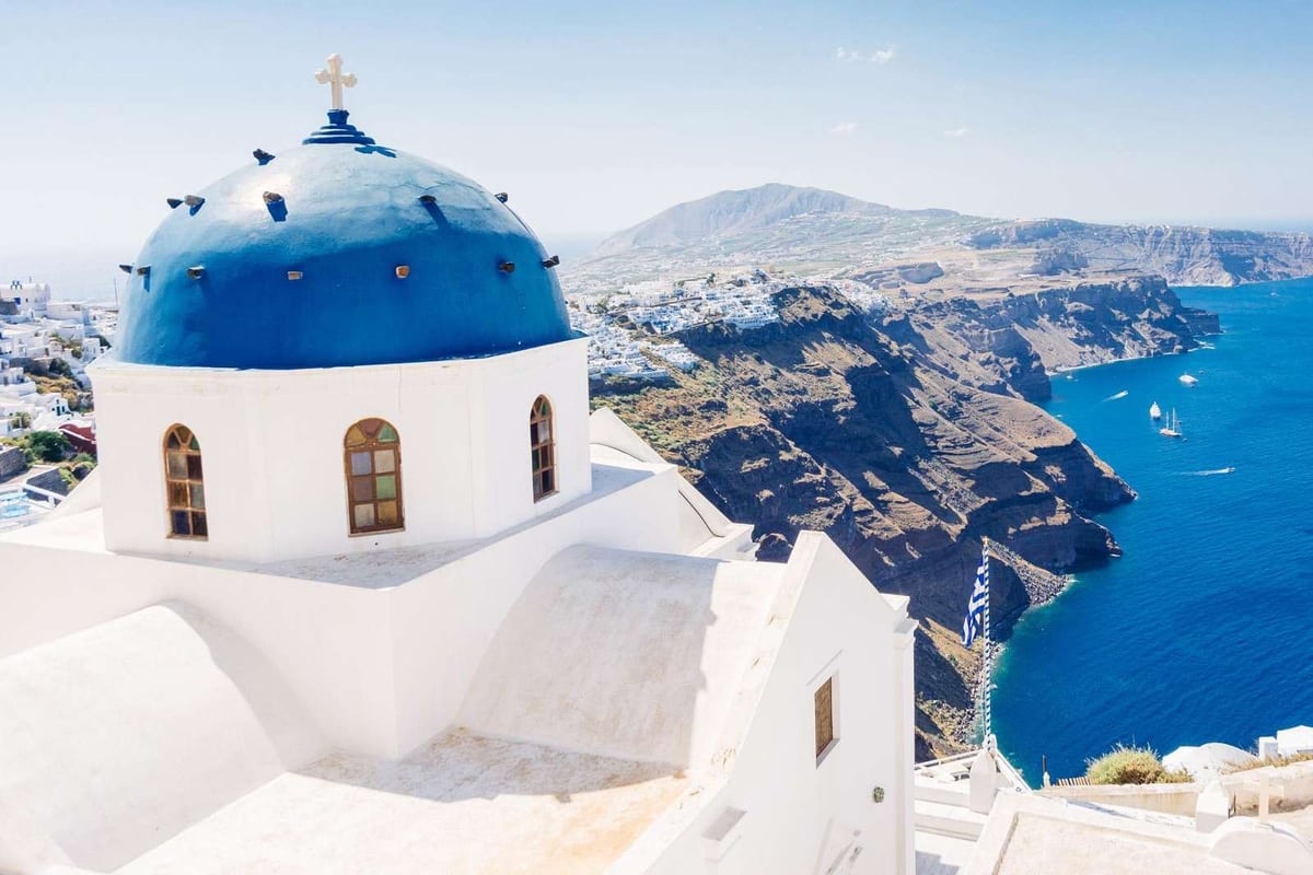
Pyrgos climbs a hill of Santorini island. The hilltop carries the Kasteli, a fort from the Venetian age, and the island was once governed from there. Megalochori, 9 kilometres from Fira, sits in the south-west and keeps old houses and white churches. Both show the older face of the island. The Greek page calls Pyrgos the highest village.
Pyrgos Kallistis, or simply Pyrgos, means Beauty Tower, or just Tower. English Wikipedia lists 1,078 inhabitants and puts the village about 7 kilometres from Fira. The Greek page says 10 kilometres. The pages differ, so read both distances as estimates. Pyrgos has held the status of a traditional settlement of Santorini island since nineteen seventy-eight.
Pyrgos was one of the five kastelia of Santorini island, the walled villages of the Venetian age. From eighteen thirty-five to nineteen fourteen the municipality of Kallisti had its seat here. The kasteli had a single gate, and tunnels below it gave residents a way out in times of need.
Inside the kasteli stands Theotokaki, a church of the Dormition and one of the oldest of Santorini island. The Greek page believes it dates from the tenth century. Higher up, the church of the Presentation was built in sixteen sixty and sixteen sixty-one. On Good Friday tin lamps are lit across the village as the procession passes.
Above the village, on the highest hill of Santorini island, stands the Monastery of Profitis Ilias. Wikivoyage warns that visitors rarely find it open, yet the view repays the climb. The Greek page says building began in the early eighteenth century. The first school of Thera opened in Pyrgos in that century, started by local notables and the abbot.
In the south-west of Santorini island, 9 kilometres from Fira, sits Megalochori. The Greek page lists 642 inhabitants and calls it a characteristic example of island architecture. Wikivoyage points to its old whitewashed churches in Cycladic style. A photo on the Greek page shows a small chapel of Saint Nicholas.
Megalochori has a long past on Santorini island. The Greek page notes traces of settlements from the Early and Late Cycladic periods in the wider area. A French Catholic priest mentions the modern village in sixteen fifty. On the first of July the village holds a feast at the church of the Holy Anargyroi.
Near Megalochori, Wikivoyage names the Heart of Santorini, another geological formation that photographers like. Buses from Fira to the Akrotiri museum call at the village on the way. English Wikipedia names Pyrgos as a village of Santorini island where tourism has left the least mark.
What do Emporio and the south show on santorini island?
Emporio, 12 kilometres from Fira, is a large old village of Santorini island with a kasteli, a tower and windmills. The south adds Akrotiri, with its castle and lighthouse, and the hill villages of Exo Gonia and Mesa Gonia. Each keeps a church, a castle or a tower that tells part of the story.
Emporio, also called Nimborios, lies at the foot of Profitis Ilias. The Greek page names it the largest village on Santorini island, with 1,938 residents in the census it cites. English Wikipedia counts 3,704 for the wider community, which also includes Perissa, Agios Georgios and Exomytis. Wikivoyage ranks it second, so pages differ.
The Goulas is a square tower in the north of Emporio on Santorini island, probably built around the fifteenth century. The Greek page says a tunnel once ran from the tower to the kasteli, the walled core. Houses stood side by side around the kasteli to shield residents from pirates. Its entrance, which locals call Porta, still stands.
Saint Nicholas Marmaritis stands at the entrance from Fira. The Greek page calls it an ancient tomb of the third century BC that became a church. Wikivoyage measures it at 4 metres on each side and says it is still used for services. Panagia Mesani, probably of the sixteenth century, has a bell tower the Greek page praises.
Opposite the Goulas rises the hill of Gavrilos, with eight windmills of the nineteenth century and Byzantine ruins. The windmills of Santorini island are listed as protected buildings. Jean-Paul Sartre visited the village in the summer of nineteen thirty-seven. It is said to have inspired the setting of his play The Flies.
Akrotiri lies on a hill at the south-west tip of Santorini island, about 15 kilometres from Fira. In the Middle Ages the castle was called La Ponta, and its Venetian tower, the Goulas, still stands on top. The Gozzadini family of Bologna held it until the early seventeenth century, later than the rest of the island.
The lighthouse at Akrotiri stands 58 metres above the sea. The light sits on the line that ships follow from Piraeus to Alexandria, past Santorini island. It dates from eighteen ninety-two and shone again in nineteen forty-five. Its light now reaches 24 nautical miles. Wikivoyage calls it a sunset spot with far fewer visitors.
Exo Gonia lies 8 kilometres south-east of Fira and 196 metres above the sea. Older maps call it Apano Gonia, the Greek page adds. The Greek page notes churches and mansions in the building style of Santorini island. The church of Agios Charalambos is one of the three largest on the island. Its feast falls on the tenth of February.
Mesa Gonia, or Episkopi Gonias, lies 6 kilometres south-east of Fira. It takes its name from Panagia Episkopi, an eleventh-century Byzantine church that was the seat of the Orthodox diocese. The earthquake of nineteen fifty-six nearly destroyed the village, and dwellers from it built Kamari on the coast. Wikivoyage notes frescoes inside the church.
Which beaches stand out on santorini island?
Along the outer edge of the archipelago, away from the caldera cliffs, Wikivoyage finds the beaches of santorini island. The same page names Kamari, Perissa, Red Beach, White Beach, Vlychada and Baxedes among the beaches that stand out. Their colours run from black to white and red.
Cliffs line the caldera side, so no shore forms there. Wikivoyage calls the archipelago young in geological terms. Waves have had little time to grind the rock into fine sand. Pebbles of varying sizes make up the shores of santorini island, and the page asks for proper footwear.
Wikipedia links each colour to the layer of rock that the cliff exposes. Hardened lava in different shades makes the sand and pebbles of each beach. Darker beaches have warmer water, because the lava absorbs heat. Wikivoyage names black, white and red as the usual colours on santorini island.
Wikivoyage describes a long beach of black sand and shingle at Kamari, on the south-east side of Thira. The airport lies about 3 kilometres to the north. The black sand continues south to Perissa, and a hill with a trail separates the two villages of santorini island.
Perissa has a long black beach too, Wikivoyage reports. It runs on through Perivolos to Agios Georgios as one near-continuous line. The line is about 3 kilometres long, with a promenade and a row of bars, hotels and restaurants. Perissa and Kamari form the centre of beach tourism on santorini island.
Red Beach lies south of Akrotiri. Wikivoyage explains the name with two details. One is the red sand. The other is the sedimentary rock of the towering cliff, which is rich in iron. The page calls the beach crowded and notes an abundance of sea life for snorkelling on santorini island.
White Beach on santorini island opens only to arrivals by sea, Wikivoyage states. Boats start at Red Beach or Akrotiri. There is no pier, so walkers step into waist-deep water to land. The beach is very small, with a handful of beach chairs and umbrellas and no facilities.
Wikivoyage lists Vlychada on the south coast as a fishing village and notes a large marina there. Its beach is popular with naturists. On the north coast of Thira, Baxedes is the main beach, with black sand. The page calls it peaceful, closer to the older island before mass tourism, a calm corner of santorini island.
Which volcanic islets belong to santorini island?
The volcanic islets of santorini island form a ring around a centre, as Wikipedia describes the caldera. Thirasia and Aspronisi sit on the rim, while Nea Kameni and Palea Kameni rise in the middle. The municipality counts Thirasia as the only other inhabited island.
Nea Kameni means new burnt island. Nobody lives there, and Wikipedia describes the shape as nearly round. Its surface covers 3.4 square kilometres, and its diameter is about 2 kilometres, Wikipedia states. Eruption after eruption piled up dacite lava and ash, and the island grew over two thousand years. It forms the current centre of activity of santorini island.
A gravel path leads walkers to the crater, and the full circuit of the rim can be walked, Wikipedia states. Wikivoyage times the boat trip from Thira at 20 minutes. Along the climb, steam and sulphur vents come into view at a safe distance. Scientists of a national volcano institute watch the island, a protected site of santorini island.
In English, Wikipedia renders Palea Kameni as Old Burnt Island. Wikipedia states that the first Kameni islet rose from the sea of santorini island in 197 BC. Strabo described flames that rose from the water for four days. Ancient writers named the islet Hiera, a name used for volcanic mountains.
Within santorini island, the private islet of Palea Kameni lies south-west of its larger neighbour, Nea Kameni. Goats graze on it, and Wikipedia mentions a small church and a hot spring on its ground. Thermal waters there are warmer than the sea, Wikipedia notes. Without a good harbour, recreational boats do not stop there.
Within santorini island, only Thera is larger than Thirasia, Wikipedia states. Wikipedia measures Thirasia at 9.3 square kilometres, with 249 people counted at the last census. Seen from Nea Kameni, it lies to the north-west. The Thera eruption cut it off from the main island, and Wikivoyage agrees.
Wikivoyage counts five villages on Thirasia, and the largest shares the island’s name. Boats call at Korfos, the old port, and at Riva, the new port. A beach lies next to Riva, and the island holds churches and monasteries. A day trip from santorini island needs a boat, and Wikipedia lists a ferry link from Ammoudi harbour.
Aspronisi means white island, after the pale pumice that covers part of it. Wikipedia gives it 650 metres by 200 metres. Steep cliffs make landing hard, yet a small anchorage and a pair of pebble beaches exist. Wikivoyage also names the Christiana islands, 20 kilometres south-west. They form a separate group, empty since the late nineteenth century.
Which museums show the story of santorini island?
The museums of santorini island stand mainly in Fira, as Wikivoyage states. Two history museums sit there. The Museum of Prehistoric Thera tells of the Bronze Age town at Akrotiri. The Archaeological Museum of Thera holds pottery, amphorae and figures.
The Museum of Prehistoric Thera replaced the old Ypapanti Church, which the earthquake of nineteen fifty-six destroyed, Wikipedia reports. It keeps a very large number of finds from digs on santorini island. Akrotiri and the nearby site of Potamos are two of the sources.
The cases begin in the Late Neolithic and end in the Late Cycladic I phase, arranged by age. The story of santorini island unfolds in sequence. Ritual objects, wall paintings, jewellery, sculptures and ceramics fill the cases. The displays also explain the island’s complex web of links to other lands, the page adds.
Bird jugs with swallows, found at Ftellos, Megalochori and Akrotiri, show the pottery of the Middle Cycladic period. Early Cycladic marble figurines and pottery have their own place. Wikipedia also shows a bronze incense holder from Akrotiri. Wikivoyage pictures a Blue Monkey wall painting from the seventeenth century BC among the exhibits.
The Archaeological Museum of Thera dates from nineteen sixty. It took the place of an older museum that fell in the earthquake, Wikipedia notes. Wikipedia places its collection between the Archaic and the Roman periods, while Wikivoyage starts at the third millennium BC. One krater with black figures, from grave number one, carries four ships around the rim.
Wikivoyage describes the Folklore Museum as a look at how life on santorini island changed. Its displays cover artisan crafts, including a cobbler and a blacksmith. They also show a distillery, a winery and an underground mine. The rooms cover cave houses and the white houses of today. The visit takes about 45 minutes, as that page states.
The Megaro Gyzi Museum is an ethnographic museum in a mansion from the seventeenth century, Wikivoyage states. Dresses, maps, landscapes and engravings from the Cycladic islands, dated from the fifteenth to the nineteenth century, fill its collection. It also shows old manuscripts and paintings and photographs of santorini island.
Beyond Fira, Perissa holds a museum of minerals and fossils, with specimens from 1.5 billion to 50,000 years old. The Santorini Wine Museum stands in Vothonas. Wikivoyage adds museums on naval history, tomatoes and ethnography across santorini island. Wikipedia links a Hellenic Ministry of Culture page for each of the two Fira history museums.
Which wines belong to santorini island?
Wine is the leading crop of Santorini island, and white grapes rule its vineyards. Assyrtiko is the flagship, joined by Athiri and Aidani. Red wine comes from Mandilaria and Mavrotragano. Volcanic ash feeds every vine, and the sweet wine Vinsanto carries a protected name of origin.
Wikipedia counts about 1,200 hectares of vines and says tourism puts this small area at risk. Wikivoyage tells another side: since the start of this century, vineyards have crowded out traditional crops. The two pages differ on the trend. The wine museum of Santorini island fills a cave near Messaria, Wikipedia states.
Wikipedia calls the vineyard soil very poor, composed of ash and rocks from the volcano. The porous, lime-rich subsoil keeps a share of the air’s humidity and lets the vines draw on it at night. The main article adds that dew is the chief source of water. So the vines stand far apart on Santorini island.
Each vine is woven into a low ring called a kouloura, with the bunches hanging inside. Leaves and stems form a screen against harsh wind and sunlight. Traveller Theodore Bent described the rings in January eighteen eighty-four. To him, each vineyard looked like rows of hampers set two yards apart. The basket habit of Santorini island is old.
Wikipedia notes that grape types are planted together in one plot. Growers can be unaware which bunch is which until picking starts in mid-August. At seventy-five, a vine is cut at the root and a new vine joins the rootstock. The yield per hectare is one tenth to one fifth of French or Californian yields.
Three classified wines come from Santorini island: Santorini, Nykteri and Vinsanto. Wikipedia describes the whites as extremely dry. It says the ashy soil gives them a sharp scent of citrus, with salty, mineral aromas. Barrel ageing adds a slight frankincense note to certain whites. The labels Santorini and Vinsanto each hold a protected designation of origin.
On Santorini island, Vinsanto is the dessert wine. Growers dry the grapes in the sun and add no sugar. The finest bottlings stay in barrel as long as twenty or twenty-five years. The wine turns dark amber, with notes of nuts, raisins and figs. One theory traces the name to packages marked Santo, with vin added before it.
Wine built the trade of Santorini island. Under Venice the wine crossed the Mediterranean, and the Ottomans left the trade alone. The Russian Orthodox Church adopted it for its services. Trade with Russia went on in wartime, because the Ottomans let island producers sell freely. In the middle years of the nineteenth century, Russia took the island’s whole wine output.
Which foods and crafts belong to santorini island?
Dry volcanic ash shapes the farm produce of Santorini island: the cherry tomato, fava, capers and the white aubergine. Wikivoyage says the soil, the dry climate and the lack of trees forced growers to choose their varieties with care. Fish, goat cheese and sweets complete the table.
The cherry tomato of Santorini island has a deep red colour. Its flesh is firm, not especially moist, and rich in seeds. The taste is sweet and strongly acidic, Wikipedia states. Rain is scarce, so the crop lives on dew, and sodium in the soil draws moisture from the air. An official designation of origin protects the name.
Regular growing of this variety began in eighteen seventy-five, Wikipedia states. A tomato factory near Monolithos, built in nineteen fifty-two, is the only one left on Santorini island. A museum documents the growing and processing history. Wikivoyage adds tomato fritters: cherry tomato slices in a batter with mint and herbs, fried in olive oil.
The seeds of Lathyrus clymenum, a plant islanders have grown for 3,500 years, become the purée called fava. Cooks serve it warm with olive oil and lemon, topped with chopped onion or with capers. Capers are another traditional favourite on Santorini island. Chlorotyri, a goat milk cheese, sometimes goes with the purée, Wikivoyage says, or appears in salads.
Compared with the mainland kind, the white aubergine has a sweeter taste and fewer seeds. It is now a rare product, Wikivoyage reports. Since the nineteen eighties, tourism has taken farmland for hotels and villas. Desalination plants largely ended the water shortage, which let growers plant crops from elsewhere. The range of crops has narrowed.
Seafood is popular on Santorini island, Wikivoyage reports, in particular grilled octopus and fried fish. Kopania are small sweets. The base is powdered barley rusk, mixed with raisins, sesame or nuts, and the dough is rolled into balls. Near Orthodox Easter, bakeries offer melitinia, a pie of fresh mizithra cheese. Sugar and mastic powder flavour the filling.
Pumice is a building material of Santorini island. Wikivoyage says its gas bubbles make it a natural insulator. So houses were set partly into the hillside or built with cellars underground. That keeps heat out in summer and warmth in during winter. The island’s pumice pits shut in nineteen eighty-six, Wikipedia notes, to spare the caldera.
Older trades show in the record too. Wikipedia calls the Bay of Armeni below Oia a former boatbuilding centre. Today only one wharf there handles minor repairs. At Akrotiri, a loom workshop points to organised weaving for export, and the town made high-quality pottery. These trades give Santorini island a craft story that starts in the Bronze Age.
When do travellers visit santorini island, and what do they pack?
For milder weather and thinner crowds, Wikivoyage points to two windows. One runs from April through June, the other from September through October. Summer brings heat and crowds to Santorini island, while the months from December to March form the quiet off-season. Pack sturdy shoes, sun cover and a light jacket.
Climate data on Wikipedia come from the Greek national weather observatory, which labels Santorini island hot semi-arid. Rain is rare, at roughly 270 millimetres in a year, and the larger share falls in winter. Warmth averages near 19 degrees Celsius over the year.
Greek Wikipedia calls the winter mild, near 12 degrees on average, and says summer rain almost never falls.
Spring is the walking season. In April and late spring, Wikivoyage reports pleasant temperatures and little chance of rain. Wildflowers cover islands that are otherwise barren, and walkers can link one town to the next on foot. Greek Easter, or the first day of April, marks the opening of the season.
Summer is the hot side of Santorini island. With hardly any trees for shade, public life slows. Restaurants and other services shut between 12:00 and 15:00, the peak of the daily heat. Cruise ships and beach-goers crowd the island, Wikivoyage adds. The summer meltemi blows from the northwest across the southern Aegean and tempers the heat.
From September the weather turns cooler. Showers become more frequent as the year closes. Seasonal trade winds down towards the end of October. Fira stays open through winter on Santorini island, and over a dozen of its restaurants serve all year. Smaller villages can have one or two places open.
Greek Wikipedia states that cruises call from March until late November, and visits go on even in winter. Wikivoyage places the high season in July, August and September. Wikipedia’s page on Oia records a top of 40 degrees in June and a low of zero in December. A light jacket therefore earns its place on Santorini island.
Wikivoyage calls the sun extreme all year, with a UV reading of 9 or 10 throughout. The cool sea breeze hides the burn, so sunscreen is needed even under a T-shirt. Dehydration and sunburn lead the list of health issues. Tap water on Santorini island is safe but salty, so travellers drink bottled water.
Beaches are generally pebbly, Wikivoyage says, and the right footwear makes the crossing comfortable. The path on Nea Kameni runs one kilometre over uneven gravel to the 130-metre summit. Tufa rock in the caves is unstable, so walkers keep to the paths. Stairs come with a stay on the caldera side, so shoes with grip suit Santorini island.
How do travellers reach santorini island?
Travellers reach santorini island by air from Athens or by sea from Piraeus, the two main options on Wikivoyage. The flight takes 30 to 45 minutes. The ferry takes about four to nine hours, depending on the boat. Schedules change with the season, so check the current table before you plan.
North of the village of Kamari stands the airport of santorini island, as the airport article places it. Wikivoyage adds a drive of about ten minutes to Fira. The airport serves military and civil flights. Its asphalt runway measures 2,197 metres, and the field takes medium-sized jets, the article states.
Regular flights link Athens with santorini island, and Wikivoyage gives a flight time of 30 to 45 minutes. It calls air travel faster than the ferry and says it avoids possible sea sickness. From late spring to October, charter flights also arrive directly from European airports. The page lists the home cities of these flights one by one.
Wikivoyage calls the airport very small, with limited seating in the gate areas. Its code is JTR, and the field stands 39 metres above sea level. An agreement hands the airport and thirteen other regional airports to a joint venture for forty years. Seasonal and charter flights to santorini island are added to the timetable outside winter.
Buses link the airport with Fira, where a traveller on santorini island changes for other towns. The airport article lists taxis, hotel pickups and hired cars as further links. The bus ride to Fira takes 10 to 15 minutes each way. Walking is possible for a fit traveller: about 5.5 kilometres, or ninety minutes, to the centre of Fira.
Ships bound for santorini island leave from Piraeus, which Wikivoyage calls the port of Athens. Greek Wikipedia measures the distance as 128 nautical miles. High-speed boats cut the trip to about four or five hours, while standard ferryboats need seven to nine. Athinios, the ferry port, was created within a bay that carries the same name, Greek Wikipedia states.
Ferries to santorini island dock at Athinios, and Wikivoyage says buses meet each arrival. In high season, a daily ferry also joins Heraklion on Crete with this port. Other boats can dock at the old port, called Gialos on the Fira page. Wikivoyage remarks that the old port seems to look as it did 50 years ago.
A cruise call at santorini island ends with a small boat. The island article says local boatmen carry passengers ashore at Skala, the old port. Wikivoyage adds that fishing boats do this at times, and that larger, decorated shuttle boats serve big ships. The old port sits beneath the caldera wall, in a spot that no road reaches.
How do travellers move around santorini island?
Buses are the public way to move around santorini island. Wikivoyage names the Fira bus station as the hub of almost every line. Taxis, rented cars, scooters and quad bikes cover the rest. Walkers have an 11-kilometre rim path from Fira to Oia that takes about three hours.
Almost every bus line on santorini island branches out from the Fira bus station. Crossing the island by bus means changing at Fira. There are no line numbers, and certain buses display no route at all. Drivers and the ticket office can name the right bus.
Wikivoyage lists three bus routes from Fira on santorini island. The first runs to Oia via Imerovigli and Firostefani. The second goes to the airport via Karterados and Megaria, and certain buses go on to Monolithos. The third line runs through Megalochori and Akrotiri village on its way to the Akrotiri museum.
On santorini island, the busiest runs to Oia, Kamari and Perissa have gaps as short as 15 minutes. Out of season, the larger share of buses run every 90 minutes. Services end by 19:00 in low season and run until midnight in peak season. Buses generally leave Fira on schedule, but return times can drift.
Sharing a taxi with other passengers is the custom across the Cyclades, Wikivoyage notes. Certain hotels advise booking a taxi in advance, because high season leaves not enough taxis. A car needs about an hour for the full length of santorini island, from Exomytis to Oia. The page recommends carrying an international driving permit when renting a car.
Scooters and quad bikes on santorini island need a driver’s licence, and a helmet is recommended for a quad. Wikivoyage calls the all-terrain label a misnomer, because quads as a rule stay on roads. Cycling is harder, since the roads have no bicycle lanes and the land is very hilly. Bicycles can be rented in Fira and Exomytis.
The way up from the old port of santorini island is the cable car or the Karavolades stairs. Its hourly capacity is 1,200 passengers, with up to six per gondola. The ride lasts three minutes, and a queue builds only when cruise ships arrive. The stairs climb 200 metres over 588 steps and are also called the Donkey Trail.
On santorini island, the rim path from Fira to Oia is 11 kilometres long. A moderate pace needs about three hours, and the climb from Fira totals over 300 metres. The signposted trail starts north of Agiou Mina Street and passes the church called the Three Bells of Fira. Parts of the path run close to unprotected cliff edges.
Which neighbouring islands lie close to santorini island?
Greek Wikipedia locates santorini island in the Cyclades, with Ios to its north and Anafi to its east. Folegandros, Sikinos, Naxos, Amorgos and Crete complete the list of neighbours. Each island gets one short paragraph below, with its link to the main island as the pages state it.
Ios sits at the midpoint between Naxos and santorini island, the Ios page states. In church terms, Ios belongs to the Metropolis of Thera, Amorgos and the Islands. Thera is another name of Santorini, and Amorgos has its own paragraph below. Steep stairways and narrow alleys leave Chora, the principal village, largely inaccessible to cars.
Anafi lies east of santorini island. The Piraeus ferry route that serves its port also stops at Heraklion on Crete and at Athinios. In the view of ancient geographers, Anafi and Santorini belonged to the Sporades. The shift into the Cyclades came only in the late Middle Ages, under Latin rule.
Four neighbours share the southern Cyclades with santorini island. The Folegandros page names them: Folegandros, Sikinos, Ios and Anafi. Venice ruled Folegandros for more than three centuries. Modern Chora marks the place of an ancient polis called Pholegandros, a member of the Delian League. A small Ecological and Folklore Museum stands in the village of Ano Meria.
Sikinos shares the Thira regional unit with santorini island and sits midway between Ios and Folegandros. The page contrasts it with Ios: Sikinos is quieter and less developed. At Episkopi, an inscription named an ancient building as the temple of the Pythian Apollo. The monument is now considered a Roman mausoleum, followed by a Byzantine church.
On the eastern edge of the Cyclades, Amorgos lies nearest to the Dodecanese group. Wikivoyage lists Katapola among the ferry destinations from santorini island. Boats alone reach Amorgos, the Amorgos page notes. Three independent city-states stood there in the Archaic period. The Dokathismata figurine style is named after a site on Amorgos.
Wikivoyage routes the ferry from Piraeus to santorini island past Paros and Naxos. The capital of Naxos has two names, Chora and Naxos City. The Naxos article names emery, a rock rich in corundum, as a product of the island. In both the Bronze Age Cycladic culture and the Archaic period, it calls the island an important centre.
Greek Wikipedia puts Crete 63 nautical miles from santorini island. Water seems to have been scarce on Thira, the island article notes. It ties this to a rain shadow cast by high ground on Crete and on the Peloponnese. Akrotiri is a Minoan site outside Crete, the homeland of that culture, the article adds.
What else do travellers ask about santorini island?
Is the volcano under santorini island still active today?
Wikipedia calls the volcano of santorini island dormant at present. The Nea Kameni article lists four major spells of eruption in the past 300 years. They began in seventeen oh seven, eighteen sixty-six, nineteen twenty-five and nineteen thirty-nine. The newest centre of activity rose above the sea in the early eighteenth century.
The latest eruption, a small one in nineteen fifty, extruded a lava dome. Wikipedia adds that Pliny the Elder, a Roman writer, reported a new island in the year nineteen. Wikivoyage dates the oldest rock still at the surface of Nea Kameni to about fifteen seventy.
Small tremors and gas odours in twenty eleven and twenty twelve prompted satellite radar studies, Wikipedia reports. They showed the magma chamber of santorini island swelling, and parts of the surface rose by 8 to 14 centimetres. Scientists equate the added molten rock with 20 years of regular activity.
How did tourism begin on santorini island?
Tourism is now the main industry of santorini island, particularly in the summer months, as Wikipedia states. Before nineteen sixty, crops and trade shaped the economy of the island. Foreign visitors began to arrive gradually after that date. Agriculture and a wine industry still form part of the economy.
In the early nineteen fifties, wealthy visitors came in small numbers aboard yachts cruising the Aegean. Island children greeted arriving passengers with flowers. Lit lanterns then lined the path from Fira down to the port, a farewell wishing the guests a happy voyage. Wikipedia calls it a spectacle.
A shipping magnate from santorini island and his wife offered to fund a hotel or a hospital there. Residents were asked to choose, and the local authorities replied that they preferred a hotel. A union of cooperatives formed in nineteen forty-seven to handle, sell abroad and publicise farm goods, above all wine.
Which animals and risks does a traveller meet on santorini island?
Wikivoyage finds no animals on santorini island that threaten people, compared with mainland Greece. It names two snake species, the leopard snake, Zamenis situla, and the cat snake, Telescopus fallax. It calls both completely harmless to humans. Two species of scorpion hide in cracks in stone walls, and the page calls them harmless too.
Donkeys and mules carry visitors up the steps from the old port of Fira, beside the cable car and walkers. Wikipedia reports criticism from animal rights organisations of this use, including too little water or rest for the animals. Wikivoyage adds that the donkeys have weight limits for riders.
The same page calls santorini island relatively crime-free and says a visitor is quite unlikely to be pickpocketed. Its cautions concern the setting rather than people. For parents, it flags the low walls beside sheer drops. For older visitors, it flags the long flights of steps.
Do earthquakes affect a visit to santorini island?
Wikivoyage calls the island vulnerable to earthquakes. Each settlement has assembly points, and the page tells visitors to note them. In an earthquake, it says, follow the orders of officials and be ready to leave. A swarm of smaller quakes later closed attractions and services islandwide as a precaution.
Wikipedia describes hundreds of minor earthquakes, up to magnitude 5, mostly around the islet of Anydros, north-east of the island. Experts first judged them tectonic rather than volcanic. Later analysis pointed to a deep intrusion of magma, the article reports. The swarm ended in late February, it adds.
The caldera article dates the start of the unrest to mid-summer. Its strongest sequence struck about 30 km north-east of santorini island. A later swarm was mostly smaller than magnitude 3 and lay between 5 and 20 km deep. It faded within about three months, and the article places the molten rock deeper than 8 km.
Which films and songs use santorini island as a setting?
Wikipedia lists films shot on location on the island. Summer Lovers was filmed there. The Sisterhood of the Traveling Pants and its sequel also used the island as a filming location. Wikivoyage adds that Greek and Brazilian television series were shot there too.
Songs follow the same pull. The Greek composer Yanni performed a piece called Santorini on an album from nineteen eighty-six. The French singer-songwriter Nolwenn Leroy found inspiration in the creeks of santorini island. An American hip hop musician shot a music video there for a song titled Santorini Greece. An Australian singer-songwriter named a song Santorini too.
Film has a home on the island as well. Wikipedia notes a yearly film festival in the open-air cinema of Kamari. A board game named Santorini takes its look from the cliffside villages of santorini island. Two video games also feature the island, as Wikipedia lists them.