
Epirus Greece is the north-west corner of the mainland, between the Pindus mountains and the Ionian Sea. Ioannina sits on its lake, the stone villages of Zagori line the Vikos Gorge, and Parga faces the sea on the coast. The tours in Greece on the home page add the rest of a Greek trip.
This page covers Ioannina, Zagori and the gorge, Metsovo and the mountains, the coast, the ancient sites and the rivers, then the questions readers raise. The hiking in Greece page holds the trails, and the Greece mainland tours page holds the routes that pass through the region.
Where does Epirus Greece lie and what sets it apart?
Epirus Greece is the north-western part of the Greek mainland. The Pindus range stands behind it, and the Ionian Sea lies in front. Its area is close to 9,200 square kilometres, mountain and coast together. Four regional units share it: Ioannina, Arta, Preveza and Thesprotia. Around 320,000 people live there, and Ioannina is the capital.
The map of Epirus Greece shows four neighbours. Western Macedonia and Thessaly border it on the east. West Greece borders the south, and Albania the north. The Ionian Sea and its islands face the western coast. The Pindus forms the eastern wall of the region.
The word Epirus means mainland. Ancient Greeks applied it to the land opposite Corfu and the Ionian islands. Hecataeus of Miletus wrote it down in the sixth century BC. The wider historical region reaches into southern Albania, but this page keeps to the Greek region.
Rugged ridges form the larger part of the land, so Epirus Greece is a mountain region first. Winds from the Ionian Sea hit the western slopes of the Pindus. Rain falls here in larger amounts than in any other part of the country. The animal life includes bears, wolves, foxes, deer and lynxes.
The national tourism organisation of Greece measures the Ionian coast of the region at 360 kilometres. Wikivoyage adds that the beaches are developed for tourism, while the mountain interior receives little attention. That split between a well-visited shore and a quiet interior sets Epirus Greece apart.
The Greek part of the land belonged to the ancient Molossians and Thesprotians, and a small part to the Chaonians. After the Fourth Crusade, the Despotate of Epirus formed here as a Byzantine successor state. The tourism body calls Arta its old capital.
The present region dates from an administrative reform of nineteen eighty-seven. A later reform, in twenty eleven, replaced the old prefectures with the four regional units. Together they hold 18 municipalities. Nearly a third of the people of Epirus Greece live in Ioannina, so the walk through the region starts there. The stops of this page are these.
- Ioannina
- Zagori and the Vikos Gorge
- Metsovo
- Konitsa and the Pindus
- Parga, Sivota and Preveza
- Dodona, Nicopolis and the Acheron
- Arta
How does Ioannina open Epirus Greece?
Ioannina opens Epirus Greece at about 500 metres of height, with Lake Pamvotis spread along its eastern side. The city holds the seat of the region and is its largest centre. A walled castle town fills a promontory in the lake, and an inhabited island lies out on the water.
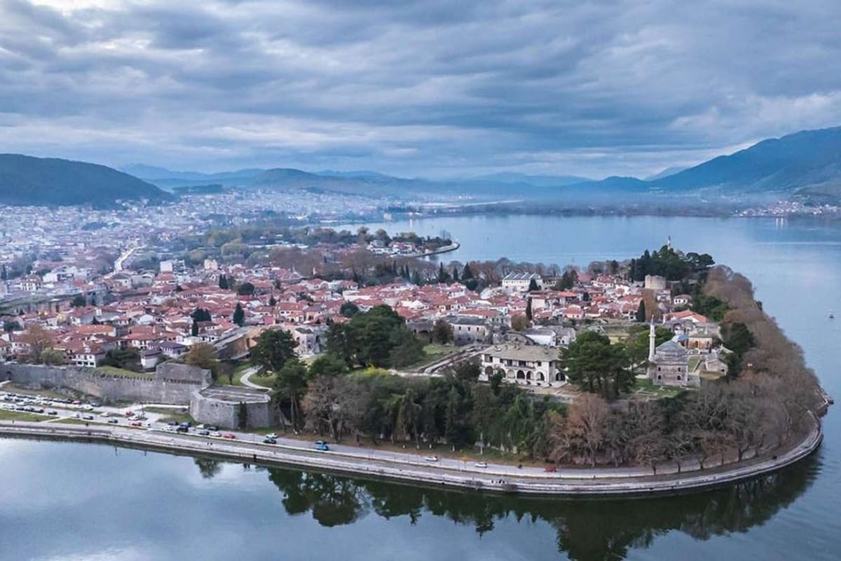
- Castle of Ioannina, the fortified old town
- Aslan Pasha Mosque, now the Municipal Ethnographic Museum
- Fethiye Mosque, with the tomb of Ali Pasha
- Byzantine Museum, on the site of the old palace
- Ioannina Island, with its late Byzantine monasteries
- Perama Cave, a show cave north of the city
The map of Epirus Greece puts Ioannina 410 kilometres north-west of Athens and 260 kilometres south-west of Thessaloniki. The port of Igoumenitsa on the Ionian Sea lies 80 kilometres to the west. The Mitsikeli mountains stand north of the lake, which lies at 470 metres.
The name Ioannina is probably a worn form of Agioannina, which means place of Saint John. Wikipedia links it to a monastery of Saint John the Baptist, around which the first settlement grew. That site lies where the castle stands today. Locals say Giannena or Yannina.
Tradition names the Byzantine emperor Justinian as the founder of the city, in the sixth century. Digs have found Hellenistic walls along the same line as the later castle walls. Families from Constantinople settled here after the Fourth Crusade. Its rise came in the late Byzantine period, in the thirteenth, fourteenth and fifteenth centuries.
The first signs of people in the basin come from the cavern of Kastritsa. They date to the Paleolithic period, 24,000 years ago, and are the earliest traces in this part of Epirus Greece. The emblem of the city shows Justinian under a drawing of the ancient theatre of Dodona.
Ali Pasha gave the castle its present form. He ruled a large, almost independent state from Ioannina, and people called him the Lion of Yannina. He began his palace in the Its Kale citadel in seventeen eighty-eight. His tomb lies at the Fethiye Mosque, under an iron lattice. Wikivoyage calls the grave a popular tourist attraction in Epirus Greece.
Built in the early seventeenth century, the Aslan Pasha Mosque holds the Municipal Ethnographic Museum. Its three departments present the Greek, Muslim and Jewish communities of the city. The collections include silver work, Epirote costumes, rugs and tapestries. The Byzantine Museum has stood on the palace site since nineteen ninety-five.
Travellers in Epirus Greece reach the island by a regular boat service from the city. It covers less than one square kilometre and measures 800 metres at its longest. Only two lake islands in Greece have a settled population, and this is one of them.
Late Byzantine monasteries stand there, and only Mount Athos and Meteora rank higher as monastic centres of Greece. A pine-covered hill rises in the middle, with the Prophet Elias monastery on top. Stone houses with slate roofs stand in the village.
Ioannina is known for hand-made silver work, and Wikivoyage counts about 90 workshops in the city. The building called the Treasury in the castle holds an exhibition on the history and methods of the craft. The tourism body calls silversmithing a world-renowned craft in Epirus Greece.
The lakefront called Molos, Litharitsia Park and Pirsinella Park give the capital of Epirus Greece its green spaces. The University of Ioannina has its seat here. North of the lake, the town of Perama has a show cave 4 kilometres from the centre. The road from Igoumenitsa to Metsovo runs through the town.
How do Zagori and the Vikos Gorge shape Epirus Greece?
Zagori is a municipality of about 1,000 square kilometres, shaped like an upturned triangle. It holds 46 stone villages, and the Vikos Gorge runs through it. Both lie in the Pindus of Epirus Greece, north of Ioannina. UNESCO lists the Zagori Cultural Landscape as World Heritage.
On a map of Epirus Greece, Ioannina touches the triangle at its southern point. The Aoos river forms the northern edge. The Varda river marks the south-east side, up to Mount Mavrovouni near Metsovo, which is 2,100 metres high. Wikipedia gives the name Zagori a probable Slavic root meaning “beyond the mountains”.
UNESCO has listed Zagori as a cultural landscape since twenty twenty-three. The listing recognises the architecture of the area as a representative example of traditional, stone-built settlements.
In Epirus Greece, the arched bridges of Zagori still help travellers cross the rivers and streams of the region. Local master craftsmen built them from local stone, mainly in the eighteenth and nineteenth centuries. Plakidas bridge, also called Kalogeriko, has three arches and stands near the village of Kipoi. Wikivoyage dates all of them to the Ottoman era.
In Epirus Greece, the Vikos Gorge opens in the southern flank of Mount Tymfi and runs for 32 kilometres. Its walls measure 120 metres at the shallowest and 1,350 metres at the deepest. The Guinness Book of Records ranks it first for depth against width, but that claim is contested.
Eocene limestone forms the upper 200 metres of the walls, with Jurassic and Cretaceous limestone below 700 metres. Grey Jurassic dolomite fills the deepest layers. A second gorge, Megas Lakkos, crosses the first at the midpoint of its main part and is equally deep.
A natural platform at Oxia gives a view of the deepest section. A newly built road of 8 kilometres links it to Monodendri. Beloi, on the eastern side, has its access from Vradeto village. Measured rim to rim at one point, the gorge is 1,100 metres across and 900 metres deep.
The main part of the gorge runs between Vikos village and Monodendri. Water flows all year only at its foot, where the Voidomatis river takes shape. The Voidomatis is 15 kilometres long and ends close to Konitsa. The name Voidomatis translates as “the eye of the ox”.
Papingo is two villages of Epirus Greece, Megalo and Mikro, at the foot of Mount Radovoli inside the national park. Mikro Papingo has 39 inhabitants in the latest census, and Papingo itself has 184. The Astraka peak of Mount Tymfi towers above them. Rock pools called the Kolymbethres were formed in the limestone by the Rogovos stream.
Founded in nineteen seventy-three, the Vikos-Aoos National Park covers 12,600 hectares of Epirus Greece, 30 kilometres north of Ioannina. Ten national parks exist on the Greek mainland, and this is one of them. Altitudes in the park span 550 to 2,497 metres. More than 100,000 visitors a year come for hiking, rafting, canoe-kayaking and mountain biking.
How do Metsovo, Konitsa and the Pindus answer Epirus Greece?
At 1,160 metres, Metsovo sits in the Pindus, with Ioannina to its west and Meteora to its east. Konitsa lies north of Ioannina beside the Aoos. Smolikas, the highest peak of the Pindus, rises above 2,600 metres within the Ioannina unit of Epirus Greece.
- Metsovo town: 1,160 metres above sea level
- Katara Pass: about 1,705 metres
- Drakolimni on Mount Tymfi: about 2,000 metres
- The small lake near the summit of Smolikas: about 2,200 metres
- Gamila, the highest peak of Mount Tymfi: 2,497 metres
- Smolikas, the summit of the Pindus: above 2,600 metres
Among Aromanian (Vlach) communities in Greece, Metsovo is the main centre. The small settlements around it use it as their hub. Farming and tourism drive its economy, and tourism flourishes in winter. In Epirus Greece, Metsovo has snowy winters, rain all year and a drying trend in summer. A ski centre stands close to the town.
Since the mid-seventeenth century, merchants of Metsovo traded in Constantinople and Venice. In the eighteenth century they reached Bucharest and Vienna. In the early nineteenth century their trade extended to Moscow, Cairo, Malta, Livorno and Trieste. The residents also guarded the local mountain passes and served travellers.
Katara Pass lies 5 kilometres north-east of Metsovo, on the edge of Epirus Greece where it meets Thessaly. It divides the river basin of the Aoos from that of the Pineios. National Road 6, which links Larissa, Trikala, Metsovo, Ioannina and Igoumenitsa, crosses it.
In Epirus Greece, walkers start from Konitsa, as do rafters on the Aoos and parapenters. The town climbs a slope of the Pindus above the meeting of the Aoos and the Voidomatis. The old Konitsa bridge spans the Aoos just before the national park.
Three theories explain the name Konitsa. One traces it to an ancient city called Knossos nearby. Another points to a Slavic phrase for horseland. A third names a local lord, Konis, who allegedly built a castle. The Chronicle of Ioannina records the name in thirteen eighty.
The peaks of Tymfi rise above 2,300 metres, and Astraka stands at 2,436 metres. Drakolimni, the dragon lake, formed after the glaciers retreated. In Epirus Greece it is a shallow lake: 4.95 metres at its deepest, with a surface of one hectare.
Smolikas stands second in height among the mountains of Greece, behind Olympus. It lies entirely within the municipality of Konitsa. Its rock is ophiolite. The Pindus measures about 160 kilometres from end to end, and its nickname is the spine of Greece.
Zagori counts two national parks in Epirus Greece, the Vikos-Aoos one and the one around Valia Kalda. The Pindus National Park, as the second is also named, lies north of Metsovo and south of Perivoli. It covers about 7,000 hectares and was founded in nineteen sixty-six. Black pine and beech form its forests, with Bosnian pine in the higher parts.
How does the coast of Parga, Sivota and Preveza answer Epirus Greece?
Along the Ionian coast of Epirus Greece, three places set the pattern. Parga crowns a rocky headland with a castle. Sivota lies beside a group of offshore islets. Preveza faces the narrow entrance of the Ambracian Gulf. Each one gives the shore a different shape.
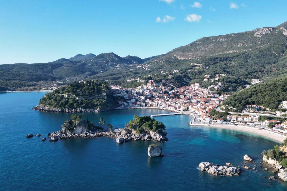
Parga lies between Preveza and Igoumenitsa on the coast of Epirus Greece. The castle crowns a small rocky peninsula. Water surrounds it on three sides, and the town lies on the fourth. The Ministry of Culture owns the ruin today. A winged lion of Saint Mark is still visible above the arched entrance gate.
The houses of Parga rise up the slope like the seats of an amphitheatre. Krioneri beach sits close to the centre of town. Across the bay, a small island carries the name of the Virgin Mary. Valtos, beside the castle, is a long beach with clear water.
Toryne, an ancient town of this area, got its name from its beach, which has the outline of a ladle. Small boats connect the port of Parga with Sarakiniko, a beach about 12 kilometres from the town centre.
In summer, boats also arrive from Paxos, Antipaxos and Corfu. Direct buses run from the town to Igoumenitsa and to Preveza. Aktio airport lies 65 kilometres from Parga.
Sivota, also written Syvota, shows another side of Epirus Greece. The village has 1,089 residents, and its municipal unit counts 2,693 across four settlements. The beaches lie on islets just offshore, and the water around them is clear. In antiquity the place was called Sybota.
A boat taxi sails around Sivota and stops at the harbour and at Blue Lagoon beach, among other places. Boat trips run to Paxos and Antipaxos, roughly 26 kilometres away. From Sivota, Parga is around half an hour away by car.
Igoumenitsa is the port where ferries from Corfu, Paxos and Italy reach Epirus Greece. The city spreads around its gulf, with a forested mountain behind it. The town itself counts 10,315 residents, and the whole municipality counts 25,698.
Preveza closes the south of Epirus Greece. The city sits on a peninsula on the north side of the gulf’s entrance. The gulf measures about 40 kilometres from end to end and 15 across. A channel 700 metres wide forms the entrance. Ferries once carried all crossings of that channel.
Seasonal flights reach this part of Epirus Greece through Aktion National Airport. It sits on the Aktion peninsula and serves Preveza and Lefkada. The undersea tunnel under the channel is the only one in Greece. In Preveza itself, a clock tower stands from the years of Venetian rule.
Which ancient sites and rivers define Epirus Greece?
Epirus Greece holds the oracle of Zeus at Dodona and the Roman city of Nicopolis. It also holds the Acheron, a river that Greek myth tied to the underworld. Five places tell that story, and the list below names them.
- Dodona, the oracle of Zeus near Ioannina
- Nicopolis, the City of Victory near Preveza
- The Necromanteion, an ancient temple on the banks of the Acheron
- The Acheron, the river of woe, which reaches the Ionian Sea
- Bridge of Arta, a stone span across the Arachthos
Dodona in Epirus Greece was the oldest Hellenic oracle. Homer names Zeus there in the earliest accounts. Priests and priestesses interpreted the rustle of the sacred oak’s leaves. A newer reading says bronze objects hung from the oak and rang in the wind, like a wind chime.
More than 4,200 oracle tablets were found, all written in Greek. They span the years from about the mid-sixth century to the early second century BCE. In the early third century BCE, King Pyrrhus chose Dodona as the religious capital of his kingdom. He added a festival with games, music and plays in a theatre.
Nicopolis shows the Roman side of Epirus Greece. Octavian founded the City of Victory two years after he beat Antony and Cleopatra at Actium. Nicopolis became capital of the new Roman province of Epirus under Trajan, in the early second century.
The theatre of Nicopolis had 77 rows of seats. The stadium had room for 10,000 spectators or more. It hosted the Actian Games, which honoured Apollo every four years. An aqueduct carried water from the Louros river over about 50 kilometres.
In Epirus Greece, the Necromanteion of Acheron was a temple of Hades and Persephone. In Homer’s Odyssey, it is the entrance by which Odysseus went down to the underworld. Necromanteion means Oracle of the Dead. The hill ruins, excavated from nineteen fifty-eight, were first given that name, but the identification is now questioned.
Rivers define Epirus Greece as much as stone does. Greek myth counted the Acheron among five rivers of the underworld. It placed the meeting of the Acheron, Pyriphlegethon and Cocytus at the Necromanteion. Their meanings are given as joyless, burning coals and lament. In Thesprotia, the Acheron runs between reedbeds and plane trees.
Arta adds a bridge and a legend to Epirus Greece. The city lies where ancient Ambracia once stood, and Pyrrhus made that city his capital. The stone bridge crosses the Arachthos on four spans and dates to the early seventeenth century. A folk ballad tells of 45 masons and 60 apprentices whose foundations fell each night.
Greek proverbs about endless delays come from that ballad. Arta also keeps a castle of the thirteenth century and the Church of the Paregoretissa. The archaeological museums of Ioannina and Arta show finds from Dodona and ancient Ambracia. A museum also stands beside the ruins of Nicopolis.
Which questions do readers raise on Epirus Greece?
How do readers reach Epirus Greece by air, road and sea?
Ioannina National Airport is the air gate to Epirus Greece. The airport stands 4 kilometres outside the city centre, and the runway measures 2,400 metres. The airport dates from nineteen thirty-two and carries the name King Pyrrhus. Wikivoyage gives the flight from Athens as 45 minutes.
Drivers heading for Epirus Greece take the Egnatia Odos, the motorway coded A2. It is 670 kilometres long and starts at the port of Igoumenitsa. The stretch over the Pindos from Grevena to Ioannina was finished by April of two thousand nine. Wikipedia states that the road has 76 tunnels and 1,650 bridges along its length.
Wikivoyage gives the drive to Ioannina as 4.5 hours from Athens and 2.5 hours from Thessaloniki. Long-distance buses also serve the city, with 6 hours from Athens and 3.5 hours from Thessaloniki.
The sea route to Epirus Greece ends at Igoumenitsa, a large passenger port by Greek standards. Wikivoyage names ferries from the Italian cities of Venice, Ancona, Bari and Brindisi, plus links to Patras and Corfu.
Wikivoyage adds that the mountain areas need your own vehicle to reach the sights. Public transport runs, but the time it takes is long. A car therefore suits the villages, while walking covers the whole of Ioannina.
Which months suit Epirus Greece, on the coast and in the mountains?
Each season suits a visit, as Wikivoyage states for Zagori, but the coast and the mountains answer differently. For Epirus Greece, the month follows the place you choose.
The coast is the milder side. Igoumenitsa lies in the Mediterranean zone with hot summers. Winter there is mild to cool and rainy, and summer is relatively dry. The sea towns of Epirus Greece therefore suit the warm months.
Ioannina lies inland. The winters are wet, and the coast is warmer. The city page adds frequent frosts and occasional snowfall, and in summer the city turns hot and moderately dry. Wikivoyage lists the sulphur baths of Kavasilas, north of Konitsa, for June to September, at 32 to 38 degrees Celsius.
In Zagori, Wikivoyage describes snow-covered villages in winter, with wood smoke from the chimneys. The first melt of the mountain snow comes at the end of February, and the streams run strongly again. Autumn turns the leaves red, copper and vermilion.
Summer brings steadier weather there, warm enough for a bath in rivers or lakes, as Wikivoyage states. The same page adds that the mountain climate of Epirus Greece brings rain and low temperatures. These surprise visitors who know Greece only for sunny beaches.
Which trip length and which base fit a first visit to Epirus Greece?
A first trip to Epirus Greece fits three days. Spend one day in Ioannina, one in the stone villages of Zagori and one on the road to the coast. Ioannina takes the first night, and a village takes the second.
Tsepelovo suits the mountain night in Epirus Greece. It is the biggest of the Zagori villages and lies 48 kilometres from Ioannina, as the village page states. The monastery of Saint John Rogovou stands two kilometres out, in the Vikaki canyon. It dates from the eleventh century.
Kipoi offers a second village base. No other Zagori village lies lower. A rocky hill carries Kipoi, near the point where the Vikos Gorge finishes in the south. Stone bridges surround it, with the Kontodimos bridge at the entrance. A museum in the village holds more than 40,000 exhibits.
Aristi sits on the western side. Wikivoyage names its monastery of Panagia Speleotissa, from the sixteenth century. It is built in and around a natural rock at the end of the Vikos canyon. The church stands near the entrance to a cave.
Vitsa lies at 955 metres on a mountain slope near the Vikos Gorge. The old double-arched bridge of Missios dates from seventeen forty-eight. A chasm splits the village into two districts, Ano Vitsa and Kato Vitsa.
Which food and crafts does Epirus Greece keep?
Pies lead the table in Epirus Greece. Wikivoyage lists pies filled with cheese, spinach, wild greens, pumpkin, and spinach with feta cheese. The Greek names are tiropita, spanakopita, hortopita, kolokothopita and tirospanakopita. The cuisine page adds that dairy products, butter and cheeses form the base of the cooking.
Goat and sheep meat comes next in Epirus Greece. Wikivoyage says the animals graze freely and eat different grasses and herbs. The Greek National Tourism Organisation names slow-cooked lamb or goat, dairy products and smoked meats as traditional dishes.
The city of Ioannina adds feta cheese from its region and baklava. Frog and eel belong to the table of Ioannina Island. The city page adds that spring water from Zagori is sold across Greece.
The crafts follow the stone villages. In the eighteenth and nineteenth centuries, Kapesovo was known for its church painters, the Bogades. They worked in dozens of churches as far south as Arta. The cobbled path down a steep slope from Kapesovo to Vradeto is a work of great craftsmanship by Epirote artisans.
The central church of Aristi holds exquisite wall paintings and a wood-carved iconostasis, as Wikivoyage states.